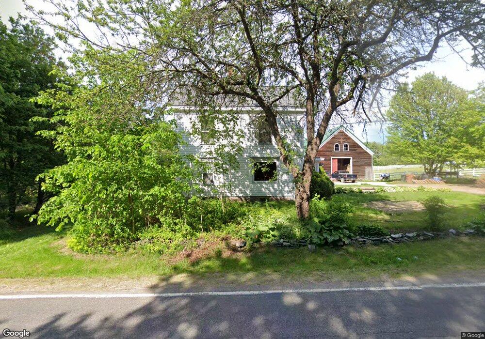
25 Watson Mill Rd Saco, ME 04072
North Saco NeighborhoodEstimated Value: $673,019 - $780,000
4
Beds
1
Bath
3,040
Sq Ft
$240/Sq Ft
Est. Value
About This Home
This home is located at 25 Watson Mill Rd, Saco, ME 04072 and is currently estimated at $729,255, approximately $239 per square foot. 25 Watson Mill Rd is a home located in York County with nearby schools including C K Burns School and Saco Middle School.
Ownership History
Date
Name
Owned For
Owner Type
Purchase Details
Closed on
May 16, 2022
Sold by
Flynn Timothy H Est
Bought by
Powers-Johnson Adrienne M
Current Estimated Value
Purchase Details
Closed on
Sep 14, 2015
Sold by
Bedell Ormand W and Flynn Timothy H
Bought by
Fritz Nicole G and Fritz Christopher A
Home Financials for this Owner
Home Financials are based on the most recent Mortgage that was taken out on this home.
Original Mortgage
$60,000
Interest Rate
4.01%
Mortgage Type
New Conventional
Purchase Details
Closed on
Sep 12, 2005
Sold by
Flynn Timothy
Bought by
Bedell Linda L and Flynn Timothy
Purchase Details
Closed on
Jun 13, 2005
Sold by
Bedell Linda L
Bought by
Flynn Timothy H and Bedell Linda L
Create a Home Valuation Report for This Property
The Home Valuation Report is an in-depth analysis detailing your home's value as well as a comparison with similar homes in the area
Home Values in the Area
Average Home Value in this Area
Purchase History
| Date | Buyer | Sale Price | Title Company |
|---|---|---|---|
| Powers-Johnson Adrienne M | -- | None Available | |
| Fritz Nicole G | -- | -- | |
| Bedell Linda L | -- | -- | |
| Flynn Timothy H | -- | -- | |
| Flynn Timothy H | -- | -- |
Source: Public Records
Mortgage History
| Date | Status | Borrower | Loan Amount |
|---|---|---|---|
| Previous Owner | Fritz Nicole G | $60,000 |
Source: Public Records
Tax History
| Year | Tax Paid | Tax Assessment Tax Assessment Total Assessment is a certain percentage of the fair market value that is determined by local assessors to be the total taxable value of land and additions on the property. | Land | Improvement |
|---|---|---|---|---|
| 2024 | $6,681 | $475,500 | $158,700 | $316,800 |
| 2023 | $6,809 | $461,600 | $158,700 | $302,900 |
| 2022 | $6,241 | $340,500 | $120,800 | $219,700 |
| 2021 | $6,079 | $322,000 | $109,500 | $212,500 |
| 2020 | $5,791 | $294,400 | $96,400 | $198,000 |
| 2019 | $5,705 | $294,400 | $96,400 | $198,000 |
| 2018 | $5,341 | $285,600 | $87,600 | $198,000 |
| 2017 | $5,118 | $264,100 | $80,600 | $183,500 |
| 2016 | $5,341 | $275,000 | $65,600 | $209,400 |
| 2015 | $5,216 | $271,400 | $64,300 | $207,100 |
| 2014 | $5,053 | $271,400 | $64,300 | $207,100 |
| 2013 | $5,043 | $271,400 | $64,300 | $207,100 |
Source: Public Records
Map
Nearby Homes
- Lot 1 & 2 Memory Ln
- 4 Lebanon Rd
- 5 Moose Creek Ln
- 75 Ash Swamp Rd
- 181 Watson Mill Rd
- 91 C Broadturn Rd
- 130 Heath Rd
- 8 Peaceful Ln
- 1 Shamrock Dr
- 3 Trapper John Rd
- 153 Mckenney Rd
- Lot 72 Martell Way
- 3 Dunn Estates Dr
- 91 B Broadturn Rd
- 90 Broadturn Rd Unit 9
- 90 Broadturn Rd Unit 1
- 6 Leah Ln
- 6 Castle Terrace
- 159 Stewart Dr
- 155 Stewart Dr
- 25 Watson Mill Rd
- 34 Watson Mill Rd
- 33 Watson Mill Rd
- 19 Watson Mill Rd
- 9 Holmes Rd
- 38 Watson Mill Rd
- 239 Mast Hill
- 16 Watson Mill Rd
- 11 Watson Mill Rd
- 0 Holmes
- 2 Holmes Rd
- 6 Holmes Rd
- 13 Holmes Rd
- 7 Watson Mill Rd
- 16 Holmes Rd
- 7 Watson Mill
- 46 Watson Mill Rd
- 0 Watson Mill
- 00 Watson Mill Rd
- 17 Holmes Rd
Your Personal Tour Guide
Ask me questions while you tour the home.