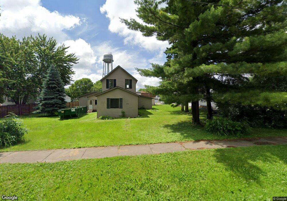
250 1st St S Montrose, MN 55363
Estimated Value: $242,129 - $359,000
3
Beds
2
Baths
1,715
Sq Ft
$166/Sq Ft
Est. Value
About This Home
This home is located at 250 1st St S, Montrose, MN 55363 and is currently estimated at $284,032, approximately $165 per square foot. 250 1st St S is a home located in Wright County with nearby schools including Montrose Elementary School, Buffalo Community Middle School, and Buffalo Senior High School.
Ownership History
Date
Name
Owned For
Owner Type
Purchase Details
Closed on
Jun 7, 2019
Sold by
Bank Of Maple Plain
Bought by
Gertjejansen Scott
Current Estimated Value
Purchase Details
Closed on
Sep 27, 2018
Sold by
Bank Of Maple Plain A Banking Corp
Bought by
Stuart Corey and Stuart Ashley
Home Financials for this Owner
Home Financials are based on the most recent Mortgage that was taken out on this home.
Original Mortgage
$85,000
Interest Rate
4.5%
Mortgage Type
Land Contract Argmt. Of Sale
Purchase Details
Closed on
Dec 23, 2003
Sold by
Falde Brothers Construction Llc
Bought by
Falde Richard A and Falde Pamela K
Purchase Details
Closed on
May 1, 2003
Sold by
Falde Martha R
Bought by
Falde Brothers Construction Llc
Create a Home Valuation Report for This Property
The Home Valuation Report is an in-depth analysis detailing your home's value as well as a comparison with similar homes in the area
Home Values in the Area
Average Home Value in this Area
Purchase History
| Date | Buyer | Sale Price | Title Company |
|---|---|---|---|
| Gertjejansen Scott | $76,000 | Title Mark | |
| Stuart Corey | $85,000 | Title Mark Llc | |
| Falde Richard A | $165,000 | -- | |
| Falde Brothers Construction Llc | $148,000 | -- |
Source: Public Records
Mortgage History
| Date | Status | Borrower | Loan Amount |
|---|---|---|---|
| Previous Owner | Stuart Corey | $85,000 | |
| Closed | Falde Richard A | -- |
Source: Public Records
Tax History Compared to Growth
Tax History
| Year | Tax Paid | Tax Assessment Tax Assessment Total Assessment is a certain percentage of the fair market value that is determined by local assessors to be the total taxable value of land and additions on the property. | Land | Improvement |
|---|---|---|---|---|
| 2025 | $2,426 | $211,900 | $78,400 | $133,500 |
| 2024 | $2,424 | $185,400 | $57,300 | $128,100 |
| 2023 | $2,442 | $209,500 | $72,300 | $137,200 |
| 2022 | $2,414 | $192,900 | $75,800 | $117,100 |
| 2021 | $2,346 | $159,200 | $49,200 | $110,000 |
| 2020 | $2,042 | $150,800 | $41,000 | $109,800 |
| 2019 | $1,572 | $147,200 | $0 | $0 |
| 2018 | $1,740 | $122,400 | $0 | $0 |
| 2017 | $1,634 | $111,600 | $0 | $0 |
| 2016 | $1,604 | $0 | $0 | $0 |
| 2015 | $1,590 | $0 | $0 | $0 |
| 2014 | -- | $0 | $0 | $0 |
Source: Public Records
Map
Nearby Homes
- 301 Center Ave S
- 161 Mindy Ln Unit 9
- 149 Mindy Ln
- 517 2nd St S
- 426 Dillon Ave N
- 137 Pheasant Ridge Dr
- 150 Pheasant Ridge Dr
- 305 Garfield Ave S
- 610 Emerson Ave N
- 140 Garner Cir
- 151 Garner Cir
- 1766 US Highway 12 SW
- 684 Aspen Ln
- 683 Aspen Ln
- 726 7th St N
- 685 Aspen Ln
- 687 Aspen Ln
- 703 7th St N
- 690 Aspen Ln
- 689 Aspen Ln