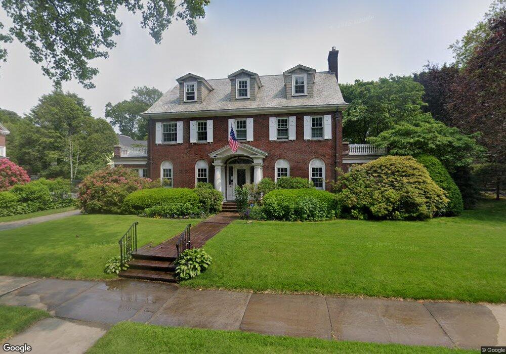
250 Dean Rd Brookline, MA 02445
Chestnut Hill NeighborhoodEstimated Value: $2,739,000 - $3,195,000
7
Beds
5
Baths
2,951
Sq Ft
$990/Sq Ft
Est. Value
About This Home
This home is located at 250 Dean Rd, Brookline, MA 02445 and is currently estimated at $2,922,020, approximately $990 per square foot. 250 Dean Rd is a home located in Norfolk County with nearby schools including Heath Elementary School, Torah Academy, and Brimmer & May School.
Ownership History
Date
Name
Owned For
Owner Type
Purchase Details
Closed on
Sep 2, 1988
Sold by
Dana Lester H
Bought by
Dana Tr Marshall A
Current Estimated Value
Home Financials for this Owner
Home Financials are based on the most recent Mortgage that was taken out on this home.
Original Mortgage
$413,000
Interest Rate
10.38%
Mortgage Type
Purchase Money Mortgage
Create a Home Valuation Report for This Property
The Home Valuation Report is an in-depth analysis detailing your home's value as well as a comparison with similar homes in the area
Home Values in the Area
Average Home Value in this Area
Purchase History
| Date | Buyer | Sale Price | Title Company |
|---|---|---|---|
| Dana Tr Marshall A | $536,000 | -- |
Source: Public Records
Mortgage History
| Date | Status | Borrower | Loan Amount |
|---|---|---|---|
| Open | Dana Tr Marshall A | $228,000 | |
| Closed | Dana Tr Marshall A | $405,000 | |
| Closed | Dana Tr Marshall A | $412,000 | |
| Closed | Dana Tr Marshall A | $413,000 |
Source: Public Records
Tax History Compared to Growth
Tax History
| Year | Tax Paid | Tax Assessment Tax Assessment Total Assessment is a certain percentage of the fair market value that is determined by local assessors to be the total taxable value of land and additions on the property. | Land | Improvement |
|---|---|---|---|---|
| 2025 | $26,580 | $2,693,000 | $1,820,000 | $873,000 |
| 2024 | $25,329 | $2,592,500 | $1,749,900 | $842,600 |
| 2023 | $21,345 | $2,140,900 | $1,250,200 | $890,700 |
| 2022 | $20,777 | $2,039,000 | $1,190,700 | $848,300 |
| 2021 | $19,213 | $1,960,500 | $1,144,900 | $815,600 |
| 2020 | $17,448 | $1,846,300 | $1,040,800 | $805,500 |
| 2019 | $16,475 | $1,758,300 | $991,200 | $767,100 |
| 2018 | $16,699 | $1,765,200 | $1,009,600 | $755,600 |
| 2017 | $16,453 | $1,665,300 | $952,400 | $712,900 |
| 2016 | $16,217 | $1,556,300 | $890,100 | $666,200 |
| 2015 | $15,534 | $1,454,500 | $831,900 | $622,600 |
| 2014 | $15,310 | $1,344,200 | $756,300 | $587,900 |
Source: Public Records
Map
Nearby Homes
- 540 Chestnut Hill Ave
- 30 Ackers Ave
- 9 Willard Rd
- 2400 Beacon St Unit 112
- 17 Strathmore Rd Unit 2
- 8 Strathmore Rd Unit G
- 44 Orkney Rd Unit 3
- 6 Sutherland Rd Unit 41
- 142 Crafts Rd
- 41 Orkney Rd
- 1880 Beacon St Unit 6
- 31 Orkney Rd Unit 54
- 675 Chestnut Hill Ave
- 19-21 Orkney Rd
- 55 Reservoir Rd Unit 2
- 1856 Beacon St Unit 2C
- 120 Seaver St Unit A103
- 120 Seaver St Unit C-102
- 3 Englewood Ave Unit 9
- 47 Englewood Ave