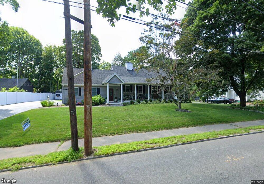
250 High St Reading, MA 01867
Estimated Value: $1,009,000 - $1,031,000
3
Beds
3
Baths
2,248
Sq Ft
$455/Sq Ft
Est. Value
About This Home
This home is located at 250 High St, Reading, MA 01867 and is currently estimated at $1,021,986, approximately $454 per square foot. 250 High St is a home located in Middlesex County with nearby schools including Alice M. Barrows Elementary School, Walter S. Parker Middle School, and Reading Memorial High School.
Ownership History
Date
Name
Owned For
Owner Type
Purchase Details
Closed on
Sep 30, 1999
Sold by
Thompson Leona E
Bought by
Bruckner Mark E and Bruckner Eileen M
Current Estimated Value
Home Financials for this Owner
Home Financials are based on the most recent Mortgage that was taken out on this home.
Original Mortgage
$232,000
Outstanding Balance
$65,233
Interest Rate
7.85%
Mortgage Type
Purchase Money Mortgage
Estimated Equity
$956,753
Purchase Details
Closed on
May 25, 1995
Sold by
Hartshorn Virginia Est and Downs
Bought by
Bertocchi Paul H and Bertocchi Stacey S
Home Financials for this Owner
Home Financials are based on the most recent Mortgage that was taken out on this home.
Original Mortgage
$141,600
Interest Rate
8.33%
Mortgage Type
Purchase Money Mortgage
Create a Home Valuation Report for This Property
The Home Valuation Report is an in-depth analysis detailing your home's value as well as a comparison with similar homes in the area
Home Values in the Area
Average Home Value in this Area
Purchase History
| Date | Buyer | Sale Price | Title Company |
|---|---|---|---|
| Bruckner Mark E | $332,000 | -- | |
| Bertocchi Paul H | $157,000 | -- |
Source: Public Records
Mortgage History
| Date | Status | Borrower | Loan Amount |
|---|---|---|---|
| Open | Bertocchi Paul H | $232,000 | |
| Previous Owner | Bertocchi Paul H | $155,000 | |
| Previous Owner | Bertocchi Paul H | $141,600 |
Source: Public Records
Tax History
| Year | Tax Paid | Tax Assessment Tax Assessment Total Assessment is a certain percentage of the fair market value that is determined by local assessors to be the total taxable value of land and additions on the property. | Land | Improvement |
|---|---|---|---|---|
| 2025 | $10,159 | $891,900 | $436,600 | $455,300 |
| 2024 | $10,042 | $856,800 | $419,400 | $437,400 |
| 2023 | $9,726 | $772,500 | $378,100 | $394,400 |
| 2022 | $9,363 | $702,400 | $343,800 | $358,600 |
| 2021 | $8,999 | $651,600 | $324,900 | $326,700 |
| 2020 | $8,795 | $630,500 | $314,400 | $316,100 |
| 2019 | $8,520 | $598,700 | $298,500 | $300,200 |
| 2018 | $7,606 | $548,400 | $273,400 | $275,000 |
| 2017 | $7,434 | $529,900 | $264,200 | $265,700 |
| 2016 | $6,917 | $477,000 | $277,800 | $199,200 |
| 2015 | $6,677 | $454,200 | $264,500 | $189,700 |
| 2014 | $6,229 | $422,600 | $246,100 | $176,500 |
Source: Public Records
Map
Nearby Homes
- 5 Washington St Unit D4
- 5 Washington St Unit A5
- 99 Grove St
- 101 King St Unit 101
- 17 Courtyard Place Unit 17
- 69 Ash St
- 30 Taylor Dr Unit 3011
- 16 Munroe Ave
- 27 Audubon Rd
- 50 Forest St
- 18 Talbot Ln Unit 18
- 48 Village St Unit 1001
- 141 Belmont St
- 2 Inwood Dr Unit 1005
- 90 Sunnyside Ave
- 119 Van Norden Rd
- 43 Ashley Place
- 20 Pinevale Ave
- 41 Winter St
- 241 Main St Unit C3
Your Personal Tour Guide
Ask me questions while you tour the home.