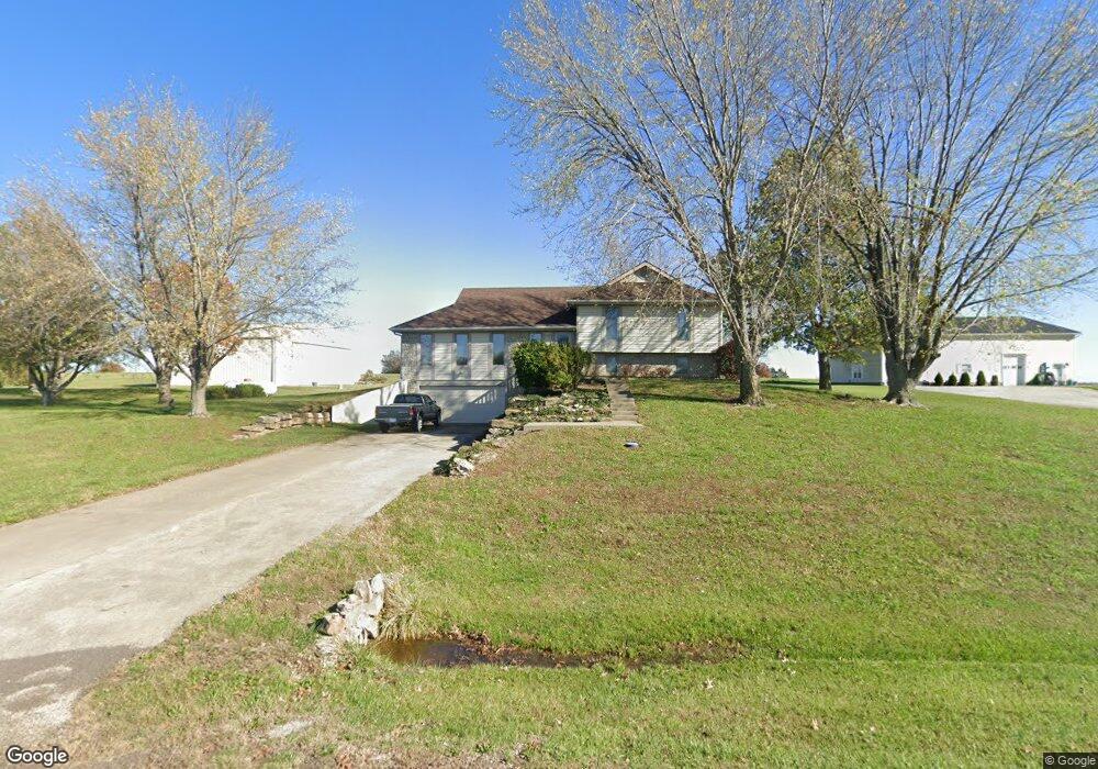
25060 160th Ct Leavenworth, KS 66048
Estimated Value: $430,971 - $487,000
3
Beds
3
Baths
1,734
Sq Ft
$265/Sq Ft
Est. Value
About This Home
This home is located at 25060 160th Ct, Leavenworth, KS 66048 and is currently estimated at $458,743, approximately $264 per square foot. 25060 160th Ct is a home located in Leavenworth County with nearby schools including Lansing Elementary School, Lansing Middle 6-8, and Lansing High 9-12.
Ownership History
Date
Name
Owned For
Owner Type
Purchase Details
Closed on
Aug 1, 2018
Sold by
Jones Gary W and Jones Gloria F
Bought by
Wilkinson Jeff
Current Estimated Value
Purchase Details
Closed on
Oct 1, 1992
Bought by
Jones Gary W and Jones Gloria F
Home Financials for this Owner
Home Financials are based on the most recent Mortgage that was taken out on this home.
Original Mortgage
$100,000
Interest Rate
8.02%
Mortgage Type
New Conventional
Create a Home Valuation Report for This Property
The Home Valuation Report is an in-depth analysis detailing your home's value as well as a comparison with similar homes in the area
Home Values in the Area
Average Home Value in this Area
Purchase History
| Date | Buyer | Sale Price | Title Company |
|---|---|---|---|
| Wilkinson Jeff | -- | Premier Title | |
| Jones Gary W | $27,000 | -- |
Source: Public Records
Mortgage History
| Date | Status | Borrower | Loan Amount |
|---|---|---|---|
| Previous Owner | Jones Gary W | $100,000 | |
| Closed | Jones Gary W | $150,000 |
Source: Public Records
Tax History Compared to Growth
Tax History
| Year | Tax Paid | Tax Assessment Tax Assessment Total Assessment is a certain percentage of the fair market value that is determined by local assessors to be the total taxable value of land and additions on the property. | Land | Improvement |
|---|---|---|---|---|
| 2025 | $5,587 | $45,050 | $7,637 | $37,413 |
| 2024 | $5,587 | $45,051 | $9,228 | $35,823 |
| 2023 | $5,587 | $42,907 | $9,228 | $33,679 |
| 2022 | $4,902 | $39,939 | $6,028 | $33,911 |
| 2021 | $4,902 | $34,802 | $5,161 | $29,641 |
| 2020 | $4,741 | $32,833 | $4,959 | $27,874 |
| 2019 | $5,618 | $40,250 | $4,614 | $35,636 |
| 2018 | $4,505 | $29,681 | $2,983 | $26,698 |
| 2017 | $3,974 | $28,393 | $2,777 | $25,616 |
| 2016 | $3,786 | $28,393 | $2,753 | $25,640 |
| 2015 | $3,474 | $26,680 | $2,753 | $23,927 |
| 2014 | -- | $25,759 | $2,753 | $23,006 |
Source: Public Records
Map
Nearby Homes
- 00000 Gilman Rd
- 16430 Dana Ln
- Lot 6 163rd St
- 24450 171st St
- 25770 Tonganoxie Dr
- 1221 S Desoto Rd
- 000 4-H Rd
- 833 Rock Creek Dr
- 25030 177th Terrace
- 875 Clearview Dr
- 811 4-H Rd
- 705 Rock Creek Dr
- 17860 Clearview Dr
- 25055 Woodridge Cir
- 15280 Roger Rd
- 922 Southfork St
- 115 W Gilman Rd
- 722 Bittersweet Rd
- 624 S Bittersweet Ln
- 77 Continental Dr
- 25060 160th Ct
- 25048 160th Ct
- 16186 Nicole Ln
- 25094 160th Ct
- 24976 160th Ct
- 16167 Dana Ln
- 25055 159th St
- 16209 Dana Ln
- 16214 Nicole Ln
- 16152 Dana Ln
- 16211 Nicole Ln
- 16114 Dana Ln
- 16223 Dana Ln
- 16264 Nicole Ln
- 16214 Dana Ln
- 16085 Gilman Rd
- 16261 Nicole Ln
- 24964 160th Ct
- 16291 Nicole Ln
- 24985 159th St