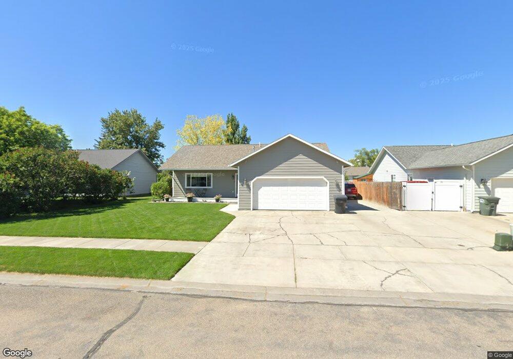
251 Buttercup Loop Kalispell, MT 59901
Estimated Value: $443,000 - $482,000
3
Beds
2
Baths
1,288
Sq Ft
$354/Sq Ft
Est. Value
About This Home
This home is located at 251 Buttercup Loop, Kalispell, MT 59901 and is currently estimated at $456,302, approximately $354 per square foot. 251 Buttercup Loop is a home located in Flathead County with nearby schools including Elrod School, Kalispell Middle School, and Flathead High School.
Ownership History
Date
Name
Owned For
Owner Type
Purchase Details
Closed on
Aug 3, 2007
Sold by
Carson W J and Carson Mary Ann
Bought by
Anderson Brock A and Anderson Kristi
Current Estimated Value
Home Financials for this Owner
Home Financials are based on the most recent Mortgage that was taken out on this home.
Original Mortgage
$159,500
Outstanding Balance
$100,987
Interest Rate
6.66%
Mortgage Type
New Conventional
Estimated Equity
$355,315
Create a Home Valuation Report for This Property
The Home Valuation Report is an in-depth analysis detailing your home's value as well as a comparison with similar homes in the area
Purchase History
| Date | Buyer | Sale Price | Title Company |
|---|---|---|---|
| Anderson Brock A | -- | Citizens Title And Escrow Co |
Source: Public Records
Mortgage History
| Date | Status | Borrower | Loan Amount |
|---|---|---|---|
| Open | Anderson Brock A | $159,500 |
Source: Public Records
Tax History
| Year | Tax Paid | Tax Assessment Tax Assessment Total Assessment is a certain percentage of the fair market value that is determined by local assessors to be the total taxable value of land and additions on the property. | Land | Improvement |
|---|---|---|---|---|
| 2025 | $2,256 | $445,900 | $0 | $0 |
| 2024 | $3,011 | $386,600 | $0 | $0 |
| 2023 | $3,794 | $386,600 | $0 | $0 |
| 2022 | $2,572 | $256,100 | $0 | $0 |
| 2021 | $2,756 | $256,100 | $0 | $0 |
| 2020 | $3,215 | $222,100 | $0 | $0 |
| 2019 | $3,223 | $222,100 | $0 | $0 |
| 2018 | $2,855 | $180,031 | $0 | $0 |
| 2017 | $2,865 | $180,031 | $0 | $0 |
| 2016 | $2,536 | $169,900 | $0 | $0 |
| 2015 | $2,537 | $169,900 | $0 | $0 |
| 2014 | $2,462 | $97,785 | $0 | $0 |
Source: Public Records
Map
Nearby Homes
- 141 Beargrass Ln
- 19 Muskrat Dr
- 1509 Eagle Dr
- 1340 Willow Glen Dr Unit 23
- 1340 Willow Glen Dr Unit 31
- 2455 Us Highway 93 S
- 1717 S Woodland Dr Unit SPC -21
- NHN U S 93 S
- 1692 Bull Run
- 1683 Bull Run
- 1519 Woodland Ave
- 3943 Lower Valley Rd
- 169 Lower Valley Rd Unit 6
- 1403 & 1405 4th Ave E
- 51 Selders Ln
- 826 11th St E
- 1024 Woodland Ave
- 1229 3rd Ave E
- 1312 2nd Ave E
- 1354 Destiny Ln
- 247 Buttercup Loop
- 255 Buttercup Loop
- 243 Buttercup Loop
- 259 Buttercup Loop
- 317 Buttercup Loop
- 313 Buttercup Loop
- 309 Buttercup Loop
- 321 Buttercup Loop
- 305 Buttercup Loop
- 263 Buttercup Loop
- 239 Buttercup Loop
- 254 Buttercup Loop
- 258 Buttercup Loop
- 250 Buttercup Loop
- 262 Buttercup Loop
- 325 Buttercup Loop
- 246 Buttercup Loop
- 235 Buttercup Loop
- 242 Buttercup Loop
- 266 Buttercup Loop