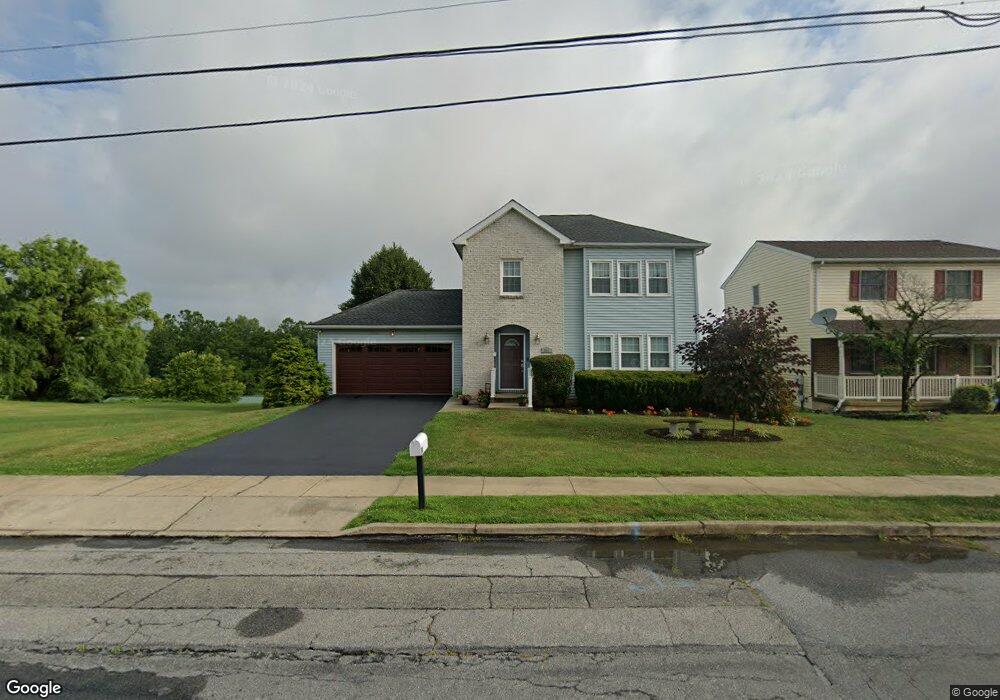
251 Maple St Coplay, PA 18037
Estimated Value: $371,000 - $395,000
3
Beds
3
Baths
1,560
Sq Ft
$245/Sq Ft
Est. Value
About This Home
This home is located at 251 Maple St, Coplay, PA 18037 and is currently estimated at $381,754, approximately $244 per square foot. 251 Maple St is a home located in Lehigh County with nearby schools including George D Steckel Elementary School, Zephyr Elementary School, and Clarence M Gockley Elementary School.
Ownership History
Date
Name
Owned For
Owner Type
Purchase Details
Closed on
Sep 23, 2002
Sold by
Rogan Christopher M and Rogan Jennifer J
Bought by
Wechsler Robert J and Wechsler Kim F
Current Estimated Value
Home Financials for this Owner
Home Financials are based on the most recent Mortgage that was taken out on this home.
Original Mortgage
$119,000
Outstanding Balance
$47,425
Interest Rate
6.27%
Mortgage Type
Purchase Money Mortgage
Estimated Equity
$334,329
Purchase Details
Closed on
Aug 1, 1996
Sold by
Miller Sharon L
Bought by
Bogan Christopher M and Bogan Jennifer J
Purchase Details
Closed on
Mar 22, 1991
Bought by
Miller Sharon L
Purchase Details
Closed on
Sep 13, 1989
Bought by
American Club Of Coplay
Purchase Details
Closed on
Jul 17, 1989
Bought by
Sardella James B and Sardella Joanne M
Create a Home Valuation Report for This Property
The Home Valuation Report is an in-depth analysis detailing your home's value as well as a comparison with similar homes in the area
Home Values in the Area
Average Home Value in this Area
Purchase History
We collect this data history from publicly available records. To have your information removed, we recommend requesting removal directly through your county’s website.
| Date | Buyer | Sale Price | Title Company |
|---|---|---|---|
| Wechsler Robert J | $159,000 | First American Title Ins Co | |
| Bogan Christopher M | $127,900 | -- | |
| Miller Sharon L | $120,000 | -- | |
| American Club Of Coplay | $42,000 | -- | |
| Sardella James B | $42,000 | -- |
Source: Public Records
Mortgage History
We collect this data history from publicly available records. To have your information removed, we recommend requesting removal directly through your county’s website.
| Date | Status | Borrower | Loan Amount |
|---|---|---|---|
| Open | Wechsler Robert J | $119,000 |
Source: Public Records
Tax History
| Year | Tax Paid | Tax Assessment Tax Assessment Total Assessment is a certain percentage of the fair market value that is determined by local assessors to be the total taxable value of land and additions on the property. | Land | Improvement |
|---|---|---|---|---|
| 2026 | $7,096 | $196,800 | $29,300 | $167,500 |
| 2025 | $6,851 | $196,800 | $29,300 | $167,500 |
| 2024 | $6,667 | $196,800 | $29,300 | $167,500 |
| 2023 | $6,306 | $196,800 | $29,300 | $167,500 |
| 2022 | $6,183 | $196,800 | $167,500 | $29,300 |
| 2021 | $5,953 | $196,800 | $29,300 | $167,500 |
| 2020 | $5,518 | $196,800 | $29,300 | $167,500 |
| 2019 | $5,184 | $196,800 | $29,300 | $167,500 |
| 2018 | $4,944 | $196,800 | $29,300 | $167,500 |
| 2017 | $4,802 | $196,800 | $29,300 | $167,500 |
| 2016 | -- | $196,800 | $29,300 | $167,500 |
| 2015 | -- | $196,800 | $29,300 | $167,500 |
| 2014 | -- | $196,800 | $29,300 | $167,500 |
Source: Public Records
Map
Nearby Homes
- 37 N 7th St
- 25 N 4th St
- 14 Magna Dr
- 5162 Stone Terrace Dr
- 118 N Front St
- 115 Chestnut St
- 12 S Front St Unit 14
- 12-14 S Front St
- 55 S 2nd St
- 147 S 5th St
- 3467 Limestone Dr
- 5598 N Coplay Rd
- 1443 Doris St
- 5510 N Coplay Rd
- 3225 Carbon St
- 1651 Canal St
- 137 W 17th St
- 1690 Newport Ave
- 3209 N Front St
- 1566 Washington Ave
Your Personal Tour Guide
Ask me questions while you tour the home.