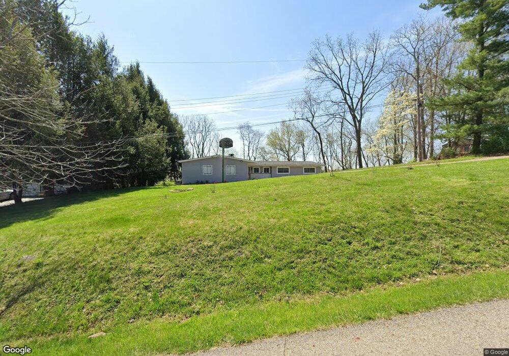
251 Queens Dr N Newark, OH 43055
Estimated Value: $327,000 - $347,000
5
Beds
4
Baths
1,756
Sq Ft
$192/Sq Ft
Est. Value
About This Home
This home is located at 251 Queens Dr N, Newark, OH 43055 and is currently estimated at $337,906, approximately $192 per square foot. 251 Queens Dr N is a home located in Licking County with nearby schools including Legend Elementary School, Liberty Middle School, and Newark High School.
Ownership History
Date
Name
Owned For
Owner Type
Purchase Details
Closed on
Feb 9, 2011
Sold by
The Bank Of New York Mellon Trust Co Nat
Bought by
Wisniewski Nancy Poore
Current Estimated Value
Purchase Details
Closed on
Sep 29, 2010
Sold by
Davis Gary A and Davis Judy L
Bought by
The Bank Of New York Mellon Trust Co and The Bank Of New York Trust Company Na
Purchase Details
Closed on
Dec 12, 2003
Sold by
Steensen Mary
Bought by
Davis Gary A and Davis Judy L
Home Financials for this Owner
Home Financials are based on the most recent Mortgage that was taken out on this home.
Original Mortgage
$148,900
Interest Rate
7.62%
Mortgage Type
Unknown
Create a Home Valuation Report for This Property
The Home Valuation Report is an in-depth analysis detailing your home's value as well as a comparison with similar homes in the area
Home Values in the Area
Average Home Value in this Area
Purchase History
| Date | Buyer | Sale Price | Title Company |
|---|---|---|---|
| Wisniewski Nancy Poore | $68,000 | Accutitle Agency Inc | |
| The Bank Of New York Mellon Trust Co | $58,000 | None Available | |
| Davis Gary A | $148,900 | -- |
Source: Public Records
Mortgage History
| Date | Status | Borrower | Loan Amount |
|---|---|---|---|
| Previous Owner | Davis Gary A | $148,900 |
Source: Public Records
Tax History Compared to Growth
Tax History
| Year | Tax Paid | Tax Assessment Tax Assessment Total Assessment is a certain percentage of the fair market value that is determined by local assessors to be the total taxable value of land and additions on the property. | Land | Improvement |
|---|---|---|---|---|
| 2024 | $3,271 | $84,570 | $19,990 | $64,580 |
| 2023 | $3,325 | $84,570 | $19,990 | $64,580 |
| 2022 | $2,393 | $54,750 | $10,470 | $44,280 |
| 2021 | $2,505 | $54,750 | $10,470 | $44,280 |
| 2020 | $2,556 | $54,750 | $10,470 | $44,280 |
| 2019 | $2,155 | $44,040 | $9,980 | $34,060 |
| 2018 | $2,144 | $0 | $0 | $0 |
| 2017 | $1,970 | $0 | $0 | $0 |
| 2016 | $1,842 | $0 | $0 | $0 |
| 2015 | $1,878 | $0 | $0 | $0 |
| 2014 | $2,390 | $0 | $0 | $0 |
| 2013 | $1,237 | $0 | $0 | $0 |
Source: Public Records
Map
Nearby Homes
- 752 Whitetail Loop
- 763 Whitetail Loop
- 750 Whitetail Loop
- 734 Whitetail Loop
- 1518 Constitution Ct
- 1684 Churchill Downs Rd
- 681 Woods Edge Ln
- 505 Courtney Dr
- 1495 Kenarbre Dr
- 259 Goosepond Rd Unit C
- 714 Olde Creek Dr
- 267 Goosepond Rd Unit A
- 261 Goosepond Rd Unit D
- 1831 Churchill Downs Rd
- 336 Myrtle Ave
- 1345 Sherwood Downs Rd W
- 139 Aqueduct Ave
- 106 Santa Anita Ave Unit 21A
- 1049 Sunrise Dr
- 105 Pimlico Ave
- 269 Queens Dr N
- 229 Queens Dr N
- 146 Pool Dr
- 61 Queens Dr N
- 170 Poole Dr
- 190 Poole Dr
- 122 Pool Dr
- 324 Queens Dr N
- 104 Poole Dr
- 86 Poole Dr
- 0 Queens Dr Unit 2339829
- 0 Queens Dr Unit 213022974
- 0 Queens Dr Unit 215010149
- 0 Queens Dr Unit 217007691
- 350 Queens Dr N
- 362 Queens Dr N
- 64 Poole Dr
- 363 Queens Dr N
- 378 Queens Dr N
- 126 Queens Dr S