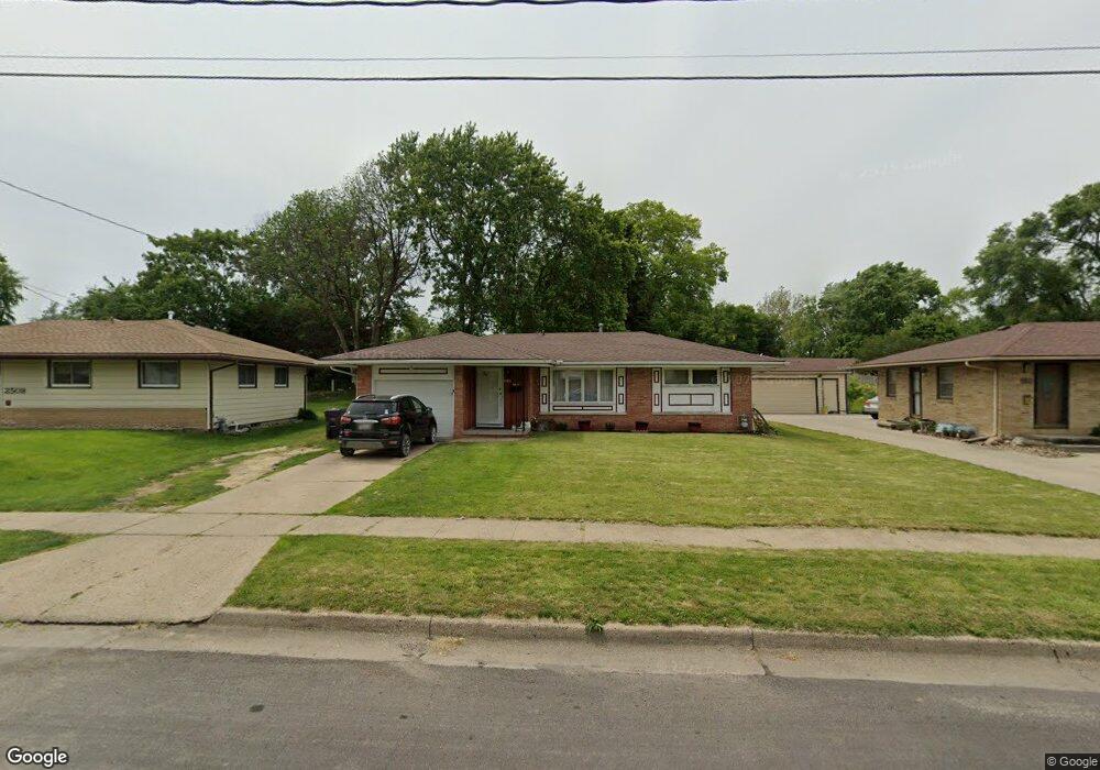
2514 Sampson St Des Moines, IA 50316
Union Park NeighborhoodEstimated Value: $181,884 - $212,000
3
Beds
1
Bath
988
Sq Ft
$199/Sq Ft
Est. Value
About This Home
This home is located at 2514 Sampson St, Des Moines, IA 50316 and is currently estimated at $196,471, approximately $198 per square foot. 2514 Sampson St is a home located in Polk County with nearby schools including Cattell Elementary School, Goodrell Middle School, and North High School.
Ownership History
Date
Name
Owned For
Owner Type
Purchase Details
Closed on
Sep 22, 2025
Sold by
Short Franklin L and Short Janet L
Bought by
Goetz Stacy L
Current Estimated Value
Purchase Details
Closed on
Mar 27, 2002
Sold by
Vanloon Forest E and Vanloon Northa I
Bought by
Short Franklin L and Short Janet L
Home Financials for this Owner
Home Financials are based on the most recent Mortgage that was taken out on this home.
Original Mortgage
$89,000
Interest Rate
6.93%
Purchase Details
Closed on
Aug 26, 1997
Sold by
Pardee Donald W and Pardee Charlotte W
Bought by
Vanloon Forest E
Create a Home Valuation Report for This Property
The Home Valuation Report is an in-depth analysis detailing your home's value as well as a comparison with similar homes in the area
Home Values in the Area
Average Home Value in this Area
Purchase History
| Date | Buyer | Sale Price | Title Company |
|---|---|---|---|
| Goetz Stacy L | -- | None Listed On Document | |
| Short Franklin L | $87,000 | -- | |
| Vanloon Forest E | $76,500 | -- |
Source: Public Records
Mortgage History
| Date | Status | Borrower | Loan Amount |
|---|---|---|---|
| Previous Owner | Short Franklin L | $89,000 |
Source: Public Records
Tax History Compared to Growth
Tax History
| Year | Tax Paid | Tax Assessment Tax Assessment Total Assessment is a certain percentage of the fair market value that is determined by local assessors to be the total taxable value of land and additions on the property. | Land | Improvement |
|---|---|---|---|---|
| 2025 | $3,358 | $192,600 | $28,800 | $163,800 |
| 2024 | $3,358 | $170,700 | $25,100 | $145,600 |
| 2023 | $3,272 | $170,700 | $25,100 | $145,600 |
| 2022 | $3,246 | $138,800 | $21,000 | $117,800 |
| 2021 | $3,036 | $138,800 | $21,000 | $117,800 |
| 2020 | $3,156 | $121,700 | $18,300 | $103,400 |
| 2019 | $3,114 | $121,700 | $18,300 | $103,400 |
| 2018 | $3,084 | $115,900 | $17,100 | $98,800 |
| 2017 | $2,878 | $115,900 | $17,100 | $98,800 |
| 2016 | $2,804 | $106,400 | $15,500 | $90,900 |
| 2015 | $2,804 | $106,400 | $15,500 | $90,900 |
| 2014 | $2,902 | $109,200 | $15,500 | $93,700 |
Source: Public Records
Map
Nearby Homes
- 2706 E 16th St
- 1432 Royer St
- 1514 Guthrie Ave
- 1422 Royer St
- 1424 Arthur Ave
- 1424 Milton Ave
- 1457 Guthrie Ave
- 2009 Glenbrook Dr
- 1602 Wilson Ave
- 2416 York St
- 1443 Wilson Ave
- 2336 E 13th St
- 2127 E 13th St
- 1526 E Jefferson Ave
- 1400 Mattern Ave
- 1420 Henderson Ave
- 1916 York St
- 2326 E 11th St
- 1913 E 13th St
- 903 Morton Ave
- 2520 Sampson St
- 2508 Sampson St
- 2526 Sampson St
- 2517 E 16th St
- 2511 E 16th St
- 1614 Arthur Ave
- 2523 E 16th St
- 2507 E 16th St
- 2509 Sampson St
- 2513 Sampson St
- 2505 Sampson St
- 2529 E 16th St
- 2501 E 16th St
- 2532 Sampson St
- 2501 Sampson St
- 2531 Sampson St
- 2535 E 16th St
- 2423 E 16th St
- 132 Arthur Ave
- 2535 Sampson St