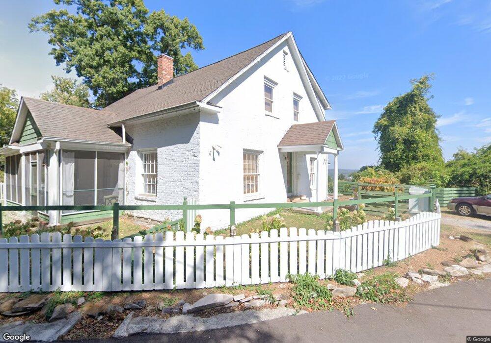
2518 Sherrod Rd Knoxville, TN 37920
South Knoxville NeighborhoodEstimated Value: $428,000 - $557,000
3
Beds
2
Baths
2,420
Sq Ft
$197/Sq Ft
Est. Value
About This Home
This home is located at 2518 Sherrod Rd, Knoxville, TN 37920 and is currently estimated at $476,543, approximately $196 per square foot. 2518 Sherrod Rd is a home located in Knox County with nearby schools including South Knox Elementary School, South Doyle Middle School, and South Doyle High School.
Ownership History
Date
Name
Owned For
Owner Type
Purchase Details
Closed on
May 20, 2004
Sold by
Peek Herschel W
Bought by
Thompson Ii Donald Vance and Thompson Emily Gallegos
Current Estimated Value
Home Financials for this Owner
Home Financials are based on the most recent Mortgage that was taken out on this home.
Original Mortgage
$88,000
Outstanding Balance
$42,042
Interest Rate
5.77%
Mortgage Type
Purchase Money Mortgage
Estimated Equity
$434,501
Create a Home Valuation Report for This Property
The Home Valuation Report is an in-depth analysis detailing your home's value as well as a comparison with similar homes in the area
Home Values in the Area
Average Home Value in this Area
Purchase History
| Date | Buyer | Sale Price | Title Company |
|---|---|---|---|
| Thompson Ii Donald Vance | $111,000 | Farragut Title Inc |
Source: Public Records
Mortgage History
| Date | Status | Borrower | Loan Amount |
|---|---|---|---|
| Open | Thompson Ii Donald Vance | $88,000 |
Source: Public Records
Tax History Compared to Growth
Tax History
| Year | Tax Paid | Tax Assessment Tax Assessment Total Assessment is a certain percentage of the fair market value that is determined by local assessors to be the total taxable value of land and additions on the property. | Land | Improvement |
|---|---|---|---|---|
| 2024 | $2,783 | $75,000 | $0 | $0 |
| 2023 | $2,514 | $67,775 | $0 | $0 |
| 2022 | $2,514 | $67,775 | $0 | $0 |
| 2021 | $1,530 | $33,375 | $0 | $0 |
| 2020 | $1,530 | $33,375 | $0 | $0 |
| 2019 | $1,530 | $33,375 | $0 | $0 |
| 2018 | $1,530 | $33,375 | $0 | $0 |
| 2017 | $1,530 | $33,375 | $0 | $0 |
| 2016 | $1,601 | $0 | $0 | $0 |
| 2015 | $1,601 | $0 | $0 | $0 |
| 2014 | $1,601 | $0 | $0 | $0 |
Source: Public Records
Map
Nearby Homes
- 520 Yarnell Ave
- 406 Millers Ave
- 2506 Davenport Rd
- 3039 Dow Dr
- 742 Lippencott St
- 1012 Kingland Ave
- 433 Saint Paul St
- 130 Woodlawn Pike
- 445 W Blount Ave Unit 210
- 445 W Blount Ave Unit 321
- 445 W Blount Ave Unit 428
- 445 W Blount Ave Unit 325
- 904 Phillips Ave Unit 101
- 2214 Lincoln St
- 1349 Bertie Rand St
- 1339 E Moody Ave
- 1137 Simpson St
- 832 Tipton Ave
- 1110 River Fork Way
- 1414 Island Home Ave
- 0 Sherrod Rd
- 2604 Sherrod Rd
- 2416 Sherrod Rd
- 2511 Sherrod Rd
- 2412 Sherrod Rd
- 2412 Sherrod Rd
- 0 Hartford St
- 2411 Sherrod Rd
- 2409 Sam Houston St
- Lot 20 Dogwood Cove Dr
- 2615 Sherrod Rd
- 2404 Sherrod Rd
- 2407 Sherrod Rd
- 307 Jonathan Ave
- 1001 Hartford St
- 2405 Sam Houston St
- 2412 Sam Houston St
- 2401 Sam Houston St
- 2648 Sherrod Rd
- 2515 Atchley St