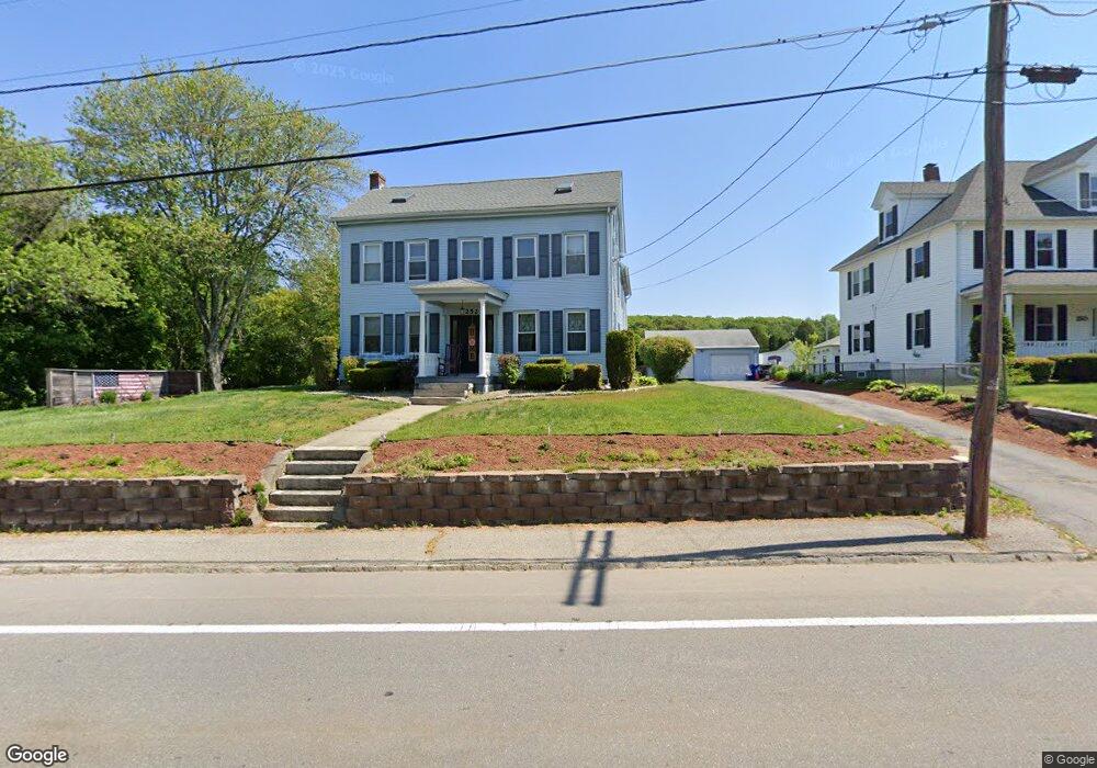
252 Main St Millville, MA 01529
Estimated Value: $482,000 - $506,000
3
Beds
2
Baths
2,240
Sq Ft
$220/Sq Ft
Est. Value
About This Home
This home is located at 252 Main St, Millville, MA 01529 and is currently estimated at $491,935, approximately $219 per square foot. 252 Main St is a home located in Worcester County with nearby schools including Blackstone-Millville Regional High School and Our Lady of the Valley Regional School.
Ownership History
Date
Name
Owned For
Owner Type
Purchase Details
Closed on
Dec 27, 2024
Sold by
Deluca Debra C
Bought by
Debra Deluca Ft and Deluca
Current Estimated Value
Purchase Details
Closed on
Aug 31, 1993
Sold by
Unibank For Savings
Bought by
Deluca Scott A and Deluca Debra
Purchase Details
Closed on
May 6, 1993
Sold by
Cullen Micheal and Unibank For Savings
Bought by
Unibank For Savings
Create a Home Valuation Report for This Property
The Home Valuation Report is an in-depth analysis detailing your home's value as well as a comparison with similar homes in the area
Home Values in the Area
Average Home Value in this Area
Purchase History
| Date | Buyer | Sale Price | Title Company |
|---|---|---|---|
| Debra Deluca Ft | -- | None Available | |
| Debra Deluca Ft | -- | None Available | |
| Deluca Scott A | $105,000 | -- | |
| Unibank For Savings | $85,000 | -- | |
| Deluca Scott A | $105,000 | -- | |
| Unibank For Savings | $85,000 | -- |
Source: Public Records
Mortgage History
| Date | Status | Borrower | Loan Amount |
|---|---|---|---|
| Previous Owner | Unibank For Savings | $188,000 | |
| Previous Owner | Unibank For Savings | $167,000 |
Source: Public Records
Tax History Compared to Growth
Tax History
| Year | Tax Paid | Tax Assessment Tax Assessment Total Assessment is a certain percentage of the fair market value that is determined by local assessors to be the total taxable value of land and additions on the property. | Land | Improvement |
|---|---|---|---|---|
| 2025 | $4,337 | $328,800 | $77,100 | $251,700 |
| 2024 | $5,185 | $392,200 | $54,700 | $337,500 |
| 2023 | $5,064 | $364,600 | $54,700 | $309,900 |
| 2022 | $4,968 | $328,800 | $77,100 | $251,700 |
| 2021 | $4,873 | $305,900 | $77,100 | $228,800 |
| 2020 | $4,758 | $296,100 | $87,000 | $209,100 |
| 2019 | $4,460 | $276,000 | $97,000 | $179,000 |
| 2018 | $7,228 | $245,300 | $97,000 | $148,300 |
| 2017 | $7,153 | $237,600 | $97,000 | $140,600 |
| 2016 | $3,871 | $228,900 | $94,500 | $134,400 |
| 2015 | $3,648 | $211,600 | $87,000 | $124,600 |
| 2014 | $3,512 | $204,400 | $84,500 | $119,900 |
Source: Public Records
Map
Nearby Homes
- 77 Chestnut Hill Rd
- 90 Chestnut Hill Rd
- 24 Lincoln St
- 34 Lincoln St
- 16 Preston St
- 23 Chesley St
- 385 River Rd
- 179 Thayer St
- 41 Thayer St
- 133 Providence St Unit D
- 160 Thayer St
- 57 Kempton Rd
- 119 Albee Rd
- 9 Balm of Life Spring Rd
- 111 Cider Mill Rd
- 0 Buxton St Unit 1386233
- 784 Victory Hwy
- 69 Adj Hill St
- 70 Hill St
- 104 Old Great Rd