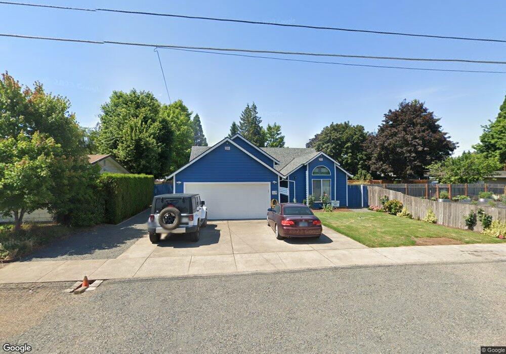
2520 E St Hubbard, OR 97032
Estimated Value: $431,856 - $459,000
3
Beds
2
Baths
1,398
Sq Ft
$322/Sq Ft
Est. Value
About This Home
This home is located at 2520 E St, Hubbard, OR 97032 and is currently estimated at $449,964, approximately $321 per square foot. 2520 E St is a home located in Marion County with nearby schools including North Marion Primary School, North Marion Middle School, and North Marion High School.
Ownership History
Date
Name
Owned For
Owner Type
Purchase Details
Closed on
Jul 19, 2014
Sold by
Rudometkin Mandy M and Rudometkin Basilio
Bought by
Lazaro Sanchez Adelina F and Lazaro Gerardo
Current Estimated Value
Home Financials for this Owner
Home Financials are based on the most recent Mortgage that was taken out on this home.
Original Mortgage
$201,960
Interest Rate
4.16%
Mortgage Type
New Conventional
Purchase Details
Closed on
Feb 17, 2004
Sold by
Rudometkin Basilio K and Rudometkin Carmen C
Bought by
Rudometkin Basilio K and Basilio K Rudometkin Trust
Create a Home Valuation Report for This Property
The Home Valuation Report is an in-depth analysis detailing your home's value as well as a comparison with similar homes in the area
Home Values in the Area
Average Home Value in this Area
Purchase History
| Date | Buyer | Sale Price | Title Company |
|---|---|---|---|
| Lazaro Sanchez Adelina F | $198,000 | Amerititle | |
| Rudometkin Basilio K | -- | -- |
Source: Public Records
Mortgage History
| Date | Status | Borrower | Loan Amount |
|---|---|---|---|
| Previous Owner | Lazaro Sanchez Adelina F | $201,960 |
Source: Public Records
Tax History
| Year | Tax Paid | Tax Assessment Tax Assessment Total Assessment is a certain percentage of the fair market value that is determined by local assessors to be the total taxable value of land and additions on the property. | Land | Improvement |
|---|---|---|---|---|
| 2025 | $3,510 | $236,110 | -- | -- |
| 2024 | $3,510 | $229,240 | -- | -- |
| 2023 | $3,389 | $222,570 | $0 | $0 |
| 2022 | $3,119 | $209,460 | $0 | $0 |
| 2021 | $3,008 | $203,360 | $0 | $0 |
| 2020 | $2,946 | $197,440 | $0 | $0 |
| 2019 | $2,697 | $191,690 | $0 | $0 |
| 2018 | $2,698 | $0 | $0 | $0 |
| 2017 | $2,554 | $0 | $0 | $0 |
| 2016 | $2,492 | $0 | $0 | $0 |
| 2015 | $2,437 | $0 | $0 | $0 |
| 2014 | $2,341 | $0 | $0 | $0 |
Source: Public Records
Map
Nearby Homes
- 18767 Oregon 99e
- 2601 N Lydia Loop
- 2514 Baines Blvd
- 2366 Baines Blvd
- 2542 Baines Blvd
- 3289 Ash St Unit 61
- 2782 Nina Place
- 2367 Dorsey Dr
- 3370 Maple St
- 3370 Maple St Unit 44
- 2469 Dorsey Dr
- 18767 Highway 99e
- 16688 Highway 99e NE
- 16688 Highway 99e NE Unit 54
- 10667 Hovenden Ln NE
- 13032 Mapleleaf Ct NE
- 2995 Molalla Rd
- 2225 Molalla Rd
- 12602 Fry Rd NE
- 10478 Crosby Rd NE
Your Personal Tour Guide
Ask me questions while you tour the home.