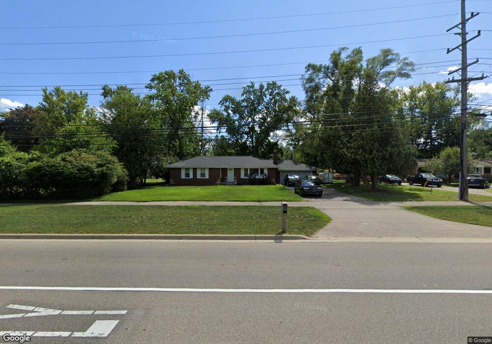
25205 W 9 Mile Rd Southfield, MI 48033
Estimated Value: $235,758 - $328,000
3
Beds
2
Baths
1,365
Sq Ft
$202/Sq Ft
Est. Value
About This Home
This home is located at 25205 W 9 Mile Rd, Southfield, MI 48033 and is currently estimated at $275,190, approximately $201 per square foot. 25205 W 9 Mile Rd is a home located in Oakland County with nearby schools including Glenn W. Levey Middle School, Bradford Academy, and David Ellis Academy West.
Ownership History
Date
Name
Owned For
Owner Type
Purchase Details
Closed on
Feb 18, 2009
Sold by
B & R Investments Llc
Bought by
Vanchristie A
Current Estimated Value
Purchase Details
Closed on
Mar 4, 2008
Sold by
Bay Creek Investment Co
Bought by
B & R Investments Llc
Purchase Details
Closed on
Jul 31, 2003
Sold by
Jacobs Anthony B and Jones Shonna La Tanya
Bought by
Land Contract Equities Inc
Purchase Details
Closed on
Jun 17, 2003
Sold by
Jacobs Shonna L and Jacobs Anthony
Bought by
Deutsche Bank National Trust Co and Bankers Trust Co Of California Na
Create a Home Valuation Report for This Property
The Home Valuation Report is an in-depth analysis detailing your home's value as well as a comparison with similar homes in the area
Home Values in the Area
Average Home Value in this Area
Purchase History
| Date | Buyer | Sale Price | Title Company |
|---|---|---|---|
| Vanchristie A | -- | Philip R Seaver Title Co Inc | |
| B & R Investments Llc | -- | None Available | |
| Land Contract Equities Inc | -- | Capital Title Ins Agency | |
| Land Contract Equities Inc | -- | Capital Title Ins Agency | |
| Lucy Alvis D | -- | Capital Title Ins Agency | |
| Deutsche Bank National Trust Co | $123,250 | -- |
Source: Public Records
Tax History Compared to Growth
Tax History
| Year | Tax Paid | Tax Assessment Tax Assessment Total Assessment is a certain percentage of the fair market value that is determined by local assessors to be the total taxable value of land and additions on the property. | Land | Improvement |
|---|---|---|---|---|
| 2022 | $2,352 | $87,800 | $19,130 | $68,670 |
| 2021 | $2,433 | $82,440 | $19,130 | $63,310 |
| 2020 | $1,964 | $71,340 | $12,360 | $58,980 |
| 2018 | $2,290 | $55,140 | $12,360 | $42,780 |
| 2015 | -- | $38,420 | $0 | $0 |
| 2014 | -- | $32,160 | $0 | $0 |
| 2011 | -- | $31,790 | $0 | $0 |
Source: Public Records
Map
Nearby Homes
- 000 Mcallister St
- 23874 W Nine Mile Rd
- 23888 W Nine Mile Rd
- 00 W Nine Mile Rd
- 0 Mcallister St
- VL Leewright Ave
- 23620 Brandywynne St
- 23705 Rockingham St
- 22215 Carleton Ave
- 25030 Thorndyke St
- 24840 Thorndyke St
- 22118 Keefer St
- 24067 Sargent Ave
- Lot 9 Outwood St
- 0000 Mcallister
- 23483 Outwood St
- 24220 Sunnypoint Dr
- 23013 Helen St
- 23217 Helen St
- 25361 Shiawassee Cir
- 25205 W 9 Mile Rd
- 25185 W 9 Mile Rd
- 25245 W Nine Mile Rd
- 25245 W 9 Mile Rd
- 25185 W Nine Mile Rd
- 25275 W 9 Mile Rd
- 25175 W 9 Mile Rd
- 25175 W Nine Mile Rd
- 22998 Carleton Ave
- 23015 Brandywynne St
- 25111 W 9 Mile Rd
- 23045 Brandywynne St
- 23010 Brandywynne St
- 22988 Carleton Ave
- 22989 Nancy Ave
- 23075 Brandywynne St
- 22999 Carleton Ave
- 23040 Brandywynne St
- 25303 W 9 Mile Rd
- 25311 W 9 Mile Rd