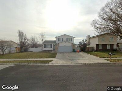
2523 W 12875 S Riverton, UT 84065
Estimated Value: $554,000 - $589,000
5
Beds
3
Baths
2,005
Sq Ft
$283/Sq Ft
Est. Value
About This Home
This home is located at 2523 W 12875 S, Riverton, UT 84065 and is currently estimated at $567,761, approximately $283 per square foot. 2523 W 12875 S is a home located in Salt Lake County with nearby schools including Southland Elementary School, Oquirrh Hills Middle School, and Riverton High School.
Ownership History
Date
Name
Owned For
Owner Type
Purchase Details
Closed on
May 18, 2023
Sold by
Duffin David C
Bought by
Dcd Property & Maintenance Llc
Current Estimated Value
Purchase Details
Closed on
Mar 21, 2017
Sold by
Us Bank Trust Na
Bought by
Duffin David C
Home Financials for this Owner
Home Financials are based on the most recent Mortgage that was taken out on this home.
Original Mortgage
$165,000
Interest Rate
4.15%
Mortgage Type
New Conventional
Purchase Details
Closed on
Nov 7, 2016
Sold by
Us Bank Trust Na
Bought by
Wells Fargo Financial Utah Inc
Purchase Details
Closed on
Dec 8, 2005
Sold by
Price Terry E
Bought by
Price Terry E and Price Carolyn M
Home Financials for this Owner
Home Financials are based on the most recent Mortgage that was taken out on this home.
Original Mortgage
$199,863
Interest Rate
6.14%
Mortgage Type
FHA
Purchase Details
Closed on
Oct 20, 2005
Sold by
Palmer Diane C
Bought by
Palmer Dale S and Palmer Kristy
Home Financials for this Owner
Home Financials are based on the most recent Mortgage that was taken out on this home.
Original Mortgage
$199,863
Interest Rate
6.14%
Mortgage Type
FHA
Purchase Details
Closed on
Sep 19, 2002
Sold by
Gundolff Michael P and Gundolff Maria I
Bought by
Palmer Diane C
Home Financials for this Owner
Home Financials are based on the most recent Mortgage that was taken out on this home.
Original Mortgage
$126,000
Interest Rate
6.24%
Purchase Details
Closed on
Jul 19, 1996
Sold by
Greene Spencer C and Greene Wendy Peart
Bought by
Gundolff Michael P and Gundolff Maria I
Home Financials for this Owner
Home Financials are based on the most recent Mortgage that was taken out on this home.
Original Mortgage
$135,992
Interest Rate
8.3%
Mortgage Type
FHA
Purchase Details
Closed on
Apr 12, 1994
Sold by
Broach Donnie R and Broach Karen S
Bought by
Greene Spencer C and Greene Wendy Peart
Home Financials for this Owner
Home Financials are based on the most recent Mortgage that was taken out on this home.
Original Mortgage
$102,150
Interest Rate
7.59%
Create a Home Valuation Report for This Property
The Home Valuation Report is an in-depth analysis detailing your home's value as well as a comparison with similar homes in the area
Home Values in the Area
Average Home Value in this Area
Purchase History
| Date | Buyer | Sale Price | Title Company |
|---|---|---|---|
| Dcd Property & Maintenance Llc | -- | None Listed On Document | |
| Duffin David C | -- | First American Title | |
| Wells Fargo Financial Utah Inc | $285,634 | Etitle Insurance Agency | |
| Price Terry E | -- | Guardian Title | |
| Price Terry E | -- | Guardian Title | |
| Palmer Dale S | -- | Meridian Title | |
| Palmer Diane C | -- | United Title Services | |
| Gundolff Michael P | -- | -- | |
| Greene Spencer C | -- | -- |
Source: Public Records
Mortgage History
| Date | Status | Borrower | Loan Amount |
|---|---|---|---|
| Previous Owner | Duffin David C | $165,000 | |
| Previous Owner | Price Terry E | $260,002 | |
| Previous Owner | Price Terry E | $199,863 | |
| Previous Owner | Palmer Dale S | $128,000 | |
| Previous Owner | Palmer Diane C | $126,000 | |
| Previous Owner | Gundolff Michael P | $135,992 | |
| Previous Owner | Greene Spencer C | $102,150 |
Source: Public Records
Tax History Compared to Growth
Tax History
| Year | Tax Paid | Tax Assessment Tax Assessment Total Assessment is a certain percentage of the fair market value that is determined by local assessors to be the total taxable value of land and additions on the property. | Land | Improvement |
|---|---|---|---|---|
| 2023 | $416 | $453,400 | $185,400 | $268,000 |
| 2022 | $416 | $462,700 | $181,800 | $280,900 |
| 2021 | $3,247 | $353,000 | $110,100 | $242,900 |
| 2020 | $2,310 | $306,900 | $110,100 | $196,800 |
| 2019 | $2,321 | $303,200 | $103,800 | $199,400 |
| 2018 | $2,184 | $280,900 | $103,800 | $177,100 |
| 2017 | $2,015 | $252,500 | $103,800 | $148,700 |
| 2016 | $2,659 | $238,400 | $103,800 | $134,600 |
| 2015 | $3,128 | $216,100 | $105,800 | $110,300 |
| 2014 | $1,777 | $203,100 | $100,900 | $102,200 |
Source: Public Records
Map
Nearby Homes
- 12978 S 2420 W
- 2597 W 12820 S
- 13105 S 2420 W
- 12867 S 2200 W
- 2332 W 13145 S
- 2668 Dry Creek Dr
- 12647 S 2525 W
- 12875 S Aspen Glen Cir
- 2028 W 12820 S
- 2531 W Mont Sur Dr
- 2401 W Adelaide Dr
- 2933 W 12875 S
- 16158 S Railcar Ln Unit 1031
- 2162 W Kimber Ln
- 1838 W 13070 S
- 3028 W Viola Ln
- 1915 W 13400 S
- 2057 W Marblewood Dr
- 12734 S 1630 W
- 1601 W 12800 S
- 2523 W 12875 S
- 2513 W 12875 S
- 2543 W 12875 S
- 2487 W 12875 S
- 2514 W 12875 S
- 2534 W 12875 S
- 2451 W 12875 S
- 2553 W 12875 S
- 2486 W 12875 S
- 12916 S 2420 W
- 2544 W 12875 S
- 12845 Old Fort Dr
- 12916 Natalie Dr
- 12916 Natalie Dr Unit 309
- 12848 Old Fort Dr
- 12908 Natalie Dr
- 12908 S 2420 W
- 2458 W 12875 S
- 12924 S 2420 W
- 12924 S 2420 W Unit 310