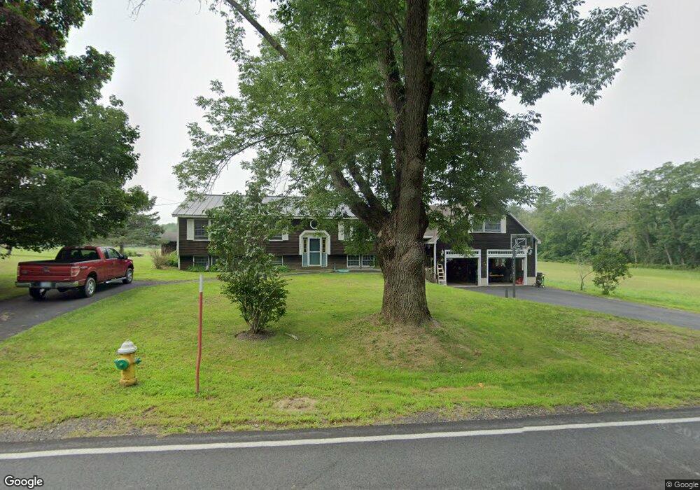
253 Fox Point Rd Newington, NH 03801
Estimated Value: $904,000 - $1,069,000
3
Beds
2
Baths
2,233
Sq Ft
$451/Sq Ft
Est. Value
About This Home
This home is located at 253 Fox Point Rd, Newington, NH 03801 and is currently estimated at $1,006,817, approximately $450 per square foot. 253 Fox Point Rd is a home located in Rockingham County with nearby schools including Newington Public School.
Ownership History
Date
Name
Owned For
Owner Type
Purchase Details
Closed on
Aug 29, 2024
Sold by
Richard N Spinney Ret and Spinney
Bought by
Spinney Paul F and Spinney Robert R
Current Estimated Value
Purchase Details
Closed on
Feb 20, 1992
Bought by
Spinney Robert R and Spinney Cheryl A
Create a Home Valuation Report for This Property
The Home Valuation Report is an in-depth analysis detailing your home's value as well as a comparison with similar homes in the area
Home Values in the Area
Average Home Value in this Area
Purchase History
| Date | Buyer | Sale Price | Title Company |
|---|---|---|---|
| Spinney Paul F | -- | None Available | |
| Spinney Paul F | -- | None Available | |
| Spinney Robert R | -- | -- |
Source: Public Records
Mortgage History
| Date | Status | Borrower | Loan Amount |
|---|---|---|---|
| Previous Owner | Spinney Robert R | $255,000 | |
| Previous Owner | Spinney Robert R | $226,000 | |
| Previous Owner | Spinney Robert R | $100,000 | |
| Previous Owner | Spinney Robert R | $50,000 |
Source: Public Records
Tax History Compared to Growth
Tax History
| Year | Tax Paid | Tax Assessment Tax Assessment Total Assessment is a certain percentage of the fair market value that is determined by local assessors to be the total taxable value of land and additions on the property. | Land | Improvement |
|---|---|---|---|---|
| 2024 | $6,298 | $799,300 | $498,800 | $300,500 |
| 2023 | $8,844 | $525,200 | $281,500 | $243,700 |
| 2022 | $5,189 | $525,200 | $281,500 | $243,700 |
| 2021 | $5,241 | $525,200 | $281,500 | $243,700 |
| 2020 | $5,194 | $525,200 | $281,500 | $243,700 |
| 2018 | $4,311 | $465,000 | $246,000 | $219,000 |
| 2017 | $4,241 | $466,000 | $246,000 | $220,000 |
| 2016 | $4,264 | $466,000 | $246,000 | $220,000 |
| 2015 | $3,877 | $408,100 | $196,800 | $211,300 |
| 2014 | $3,967 | $408,100 | $260,190 | $147,910 |
| 2011 | $3,343 | $373,500 | $156,300 | $217,200 |
Source: Public Records
Map
Nearby Homes
- 36 Shipwright Way
- 71 Shipwright Way
- SLIP 15 Little Bay Marina
- 10 Shipwright Way
- 18 Little Bay Dr
- 28 Little Bay Dr
- 33 Little Bay Dr
- 27 Wentworth Terrace
- 354 Dover Point Rd
- 348 Dover Point Rd
- 263 Durham Point Rd
- 0 Cote Dr
- 37 Cedar Point Rd
- 59 Clearwater Dr
- 245 Piscataqua Rd
- 5 Blue Heron Dr
- Slip B18 Little Bay
- 367 Durham Point Rd
- 25 Rogers Point Dr
- 0 Franks Fort Island Unit 1631886
- 245 Fox Point Rd
- 5 Carters Ln
- 262 Fox Point Rd
- 241 Fox Point Rd
- 17 Carters Ln
- 233 Fox Point Rd
- 11 Carters Ln
- 1 Little Bay Rd
- 276 Fox Point Rd
- 23 Little Bay Rd
- 20 Little Bay Rd
- 288 Fox Point Rd
- 10 Little Bay Road Extension
- 29 Carters Ln
- 31 Little Bay Rd
- 46 Carters Ln
- 252 Fox Point Rd
- 212 Fox Point Rd
- 55 Little Bay Rd
- 32 Old Post Rd