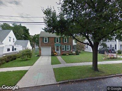
254 Locust St Holyoke, MA 01040
Estimated Value: $287,811 - $341,000
3
Beds
2
Baths
1,236
Sq Ft
$249/Sq Ft
Est. Value
About This Home
This home is located at 254 Locust St, Holyoke, MA 01040 and is currently estimated at $308,203, approximately $249 per square foot. 254 Locust St is a home located in Hampden County with nearby schools including Lt. Elmer J. McMahon Elementary School, Holyoke High School, and First Lutheran Christian School.
Ownership History
Date
Name
Owned For
Owner Type
Purchase Details
Closed on
Sep 22, 1995
Sold by
Mcdonough Ellen M and Sears Elizabeth A
Bought by
Lauzier Karen E
Current Estimated Value
Home Financials for this Owner
Home Financials are based on the most recent Mortgage that was taken out on this home.
Original Mortgage
$60,000
Interest Rate
7.81%
Mortgage Type
Purchase Money Mortgage
Create a Home Valuation Report for This Property
The Home Valuation Report is an in-depth analysis detailing your home's value as well as a comparison with similar homes in the area
Home Values in the Area
Average Home Value in this Area
Purchase History
| Date | Buyer | Sale Price | Title Company |
|---|---|---|---|
| Lauzier Karen E | $77,500 | -- |
Source: Public Records
Mortgage History
| Date | Status | Borrower | Loan Amount |
|---|---|---|---|
| Open | Lauzier Karen E | $70,000 | |
| Closed | Arble Karen E | $80,000 | |
| Closed | Lauzier Karen E | $30,000 | |
| Closed | Lauzier Karen E | $59,500 | |
| Closed | Lauzier Karen E | $60,000 |
Source: Public Records
Tax History Compared to Growth
Tax History
| Year | Tax Paid | Tax Assessment Tax Assessment Total Assessment is a certain percentage of the fair market value that is determined by local assessors to be the total taxable value of land and additions on the property. | Land | Improvement |
|---|---|---|---|---|
| 2025 | $4,349 | $249,100 | $42,200 | $206,900 |
| 2024 | $4,057 | $214,100 | $40,000 | $174,100 |
| 2023 | $3,870 | $206,300 | $40,000 | $166,300 |
| 2022 | $3,686 | $191,400 | $40,000 | $151,400 |
| 2021 | $4,258 | $179,800 | $36,400 | $143,400 |
| 2020 | $4,115 | $171,600 | $36,400 | $135,200 |
| 2019 | $3,156 | $163,600 | $31,000 | $132,600 |
| 2018 | $3,000 | $156,800 | $31,000 | $125,800 |
| 2017 | $3,006 | $156,800 | $31,000 | $125,800 |
| 2016 | $2,912 | $152,300 | $31,000 | $121,300 |
| 2015 | $2,900 | $152,300 | $31,000 | $121,300 |
Source: Public Records
Map
Nearby Homes
- 314 Mackenzie Ave
- 14 Ladd St
- 14 Anderson Ave
- 86 Sycamore St
- 28 Portland St
- 311 Walnut St
- 3 Parkview Terrace Unit 3
- 3 Parkview Terrace Unit 1
- 3 Parkview Terrace Unit 4
- 342 Sargeant St
- 270 Walnut St
- 1801 Northampton St
- 8 Quirk Ave
- 807 High St
- 232 Elm St
- 0 High St
- 215 Elm St
- 1 Monroe St
- 167 Oak St
- 13 Hampshire St
- 254 Locust St
- 240 Locust St
- 260 Locust St
- 377 Linden St
- 238 Locust St
- 379 Linden St
- 371 Linden St
- 257 Locust St
- 253 Locust St
- 263 Locust St
- 363 Linden St Unit 365
- 236 Locust St
- 304 Mackenzie Ave
- 320 Mackenzie Ave
- 359 Linden St
- 241 Locust St
- 324 Mackenzie Ave
- 237 Locust St
- 11 Anderson Ave
- 206 W Franklin St
