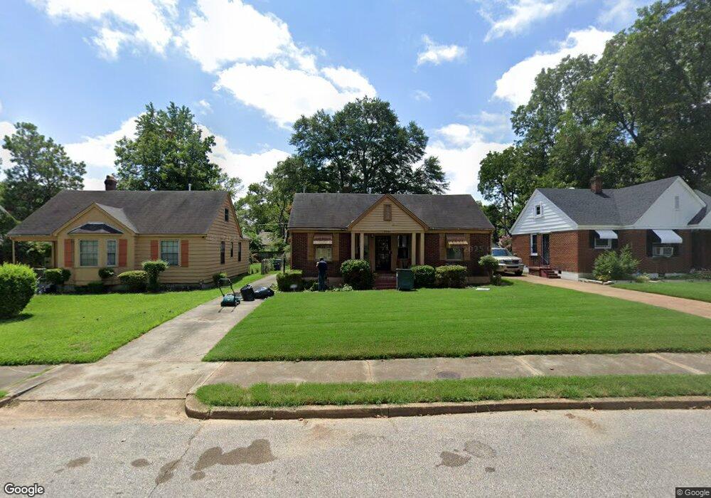
2543 Larose Ave Memphis, TN 38114
Southeast Memphis NeighborhoodEstimated Value: $74,000 - $104,000
2
Beds
1
Bath
1,040
Sq Ft
$82/Sq Ft
Est. Value
About This Home
This home is located at 2543 Larose Ave, Memphis, TN 38114 and is currently estimated at $85,301, approximately $82 per square foot. 2543 Larose Ave is a home located in Shelby County with nearby schools including Bethel Grove Elementary School, Sherwood Middle, and Melrose High School.
Ownership History
Date
Name
Owned For
Owner Type
Purchase Details
Closed on
Aug 5, 2020
Sold by
Global Midsouth Corp
Bought by
Brown Kieth
Current Estimated Value
Purchase Details
Closed on
Mar 6, 2014
Sold by
Sita Enterprise Llc
Bought by
Global Midsouth Corp
Purchase Details
Closed on
Jun 15, 2006
Sold by
Elite Diversified Corp
Bought by
Sita Enterprise
Purchase Details
Closed on
May 31, 2006
Sold by
Stanley Dorothy B and Stanley Walter M
Bought by
Elite Diversified Corp
Purchase Details
Closed on
Oct 8, 1997
Sold by
Stanley Dorothy B
Bought by
Stanley Walter M
Create a Home Valuation Report for This Property
The Home Valuation Report is an in-depth analysis detailing your home's value as well as a comparison with similar homes in the area
Home Values in the Area
Average Home Value in this Area
Purchase History
| Date | Buyer | Sale Price | Title Company |
|---|---|---|---|
| Brown Kieth | -- | None Available | |
| Global Midsouth Corp | -- | None Available | |
| Sita Enterprise | -- | None Available | |
| Elite Diversified Corp | -- | None Available | |
| Stanley Walter M | $9,500 | Mid South Title Insurance Co |
Source: Public Records
Tax History Compared to Growth
Tax History
| Year | Tax Paid | Tax Assessment Tax Assessment Total Assessment is a certain percentage of the fair market value that is determined by local assessors to be the total taxable value of land and additions on the property. | Land | Improvement |
|---|---|---|---|---|
| 2025 | -- | $16,325 | $2,450 | $13,875 |
| 2024 | $413 | $12,175 | $1,125 | $11,050 |
| 2023 | $742 | $12,175 | $1,125 | $11,050 |
| 2022 | $742 | $12,175 | $1,125 | $11,050 |
| 2021 | $881 | $12,175 | $1,125 | $11,050 |
| 2020 | $625 | $8,625 | $1,125 | $7,500 |
| 2019 | $276 | $8,625 | $1,125 | $7,500 |
| 2018 | $276 | $8,625 | $1,125 | $7,500 |
| 2017 | $282 | $8,625 | $1,125 | $7,500 |
| 2016 | $376 | $8,600 | $0 | $0 |
| 2014 | $376 | $8,600 | $0 | $0 |
Source: Public Records
Map
Nearby Homes
- 2481 Kimball Ave
- 2637 Arlington Ave
- 2481 Browning Ave
- 2607 Barron Ave
- 2589 Browning Ave
- 2400 Kimball Ave
- 1609 Hugenot St
- 2421 Arlington Ave
- 2383 Lowell Ave
- 2585 Filmore Ave
- 2621 Dunn Ave
- 2764 Burns Ave
- 2763 Fizer Rd
- 1059 S Willett St S
- 2768 Burns Ave
- 1720 Airways Blvd
- 1499 Hamilton St
- 1495 Dallas St
- 2727 Dunn Ave
- 1580 Marianna St
- 2539 Larose Ave
- 2549 Larose Ave
- 2553 Larose Ave
- 2533 Larose Ave
- 2546 Lowell Ave
- 2540 Lowell Ave
- 2550 Lowell Ave
- 2536 Lowell Ave
- 2527 Larose Ave
- 2554 Lowell Ave
- 2544 Larose Ave
- 2538 Larose Ave
- 2550 Larose Ave
- 2563 Larose Ave
- 2530 Lowell Ave
- 2554 Larose Ave
- 2523 Larose Ave
- 2532 Larose Ave
- 2522 Lowell Ave
- 2518 Lowell Ave