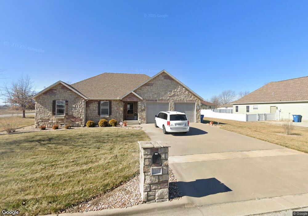
2543 Theo St Carthage, MO 64836
Estimated Value: $309,592 - $382,000
3
Beds
2
Baths
2,008
Sq Ft
$169/Sq Ft
Est. Value
About This Home
This home is located at 2543 Theo St, Carthage, MO 64836 and is currently estimated at $338,398, approximately $168 per square foot. 2543 Theo St is a home located in Jasper County with nearby schools including Carthage High School, St. Ann's Catholic School, and Victory Academy.
Ownership History
Date
Name
Owned For
Owner Type
Purchase Details
Closed on
Oct 30, 2020
Sold by
Farrran Christopher D and Farran Hollie B
Bought by
Roy & Fern Schoenhals Ret
Current Estimated Value
Purchase Details
Closed on
Aug 20, 2012
Sold by
Bradley Ray and Bradley Teresa
Bought by
Farran Christopher D and Farran Hollie B
Home Financials for this Owner
Home Financials are based on the most recent Mortgage that was taken out on this home.
Original Mortgage
$171,000
Interest Rate
3.57%
Mortgage Type
New Conventional
Purchase Details
Closed on
Jan 14, 2011
Sold by
Willis Brad and Willis Amanda
Bought by
Bradley Ray and Bradley Teresa
Home Financials for this Owner
Home Financials are based on the most recent Mortgage that was taken out on this home.
Original Mortgage
$161,000
Interest Rate
4.56%
Mortgage Type
Future Advance Clause Open End Mortgage
Create a Home Valuation Report for This Property
The Home Valuation Report is an in-depth analysis detailing your home's value as well as a comparison with similar homes in the area
Home Values in the Area
Average Home Value in this Area
Purchase History
| Date | Buyer | Sale Price | Title Company |
|---|---|---|---|
| Roy & Fern Schoenhals Ret | -- | None Available | |
| Farran Christopher D | -- | None Available | |
| Bradley Ray | -- | Fatco |
Source: Public Records
Mortgage History
| Date | Status | Borrower | Loan Amount |
|---|---|---|---|
| Previous Owner | Farran Christopher D | $171,000 | |
| Previous Owner | Bradley Ray | $161,000 |
Source: Public Records
Tax History Compared to Growth
Tax History
| Year | Tax Paid | Tax Assessment Tax Assessment Total Assessment is a certain percentage of the fair market value that is determined by local assessors to be the total taxable value of land and additions on the property. | Land | Improvement |
|---|---|---|---|---|
| 2025 | $1,810 | $39,500 | $5,350 | $34,150 |
| 2024 | $1,810 | $35,170 | $5,350 | $29,820 |
| 2023 | $1,810 | $35,170 | $5,350 | $29,820 |
| 2022 | $1,803 | $35,140 | $5,350 | $29,790 |
| 2021 | $1,783 | $35,140 | $5,350 | $29,790 |
| 2020 | $1,704 | $32,190 | $5,350 | $26,840 |
| 2019 | $1,708 | $32,190 | $5,350 | $26,840 |
| 2018 | $1,718 | $32,470 | $0 | $0 |
| 2017 | $1,722 | $32,470 | $0 | $0 |
| 2016 | $1,762 | $33,320 | $0 | $0 |
| 2015 | -- | $33,320 | $0 | $0 |
| 2014 | -- | $33,320 | $0 | $0 |
Source: Public Records
Map
Nearby Homes
- TBD George E Phelps Blvd
- TBD Lexie Ln
- 2512 Holman Ct
- NE COR Airport Dr & River
- 739 Sheridan St
- XXXX Clinton
- 1004 Gene Taylor Dr
- 839 Modern Way
- 909 Durward Hall Dr
- 837 Modern Way
- 925 Gene Taylor Dr
- 1211 E Airport Dr
- 2206 Benjamin Dr
- 1341 E Airport Dr
- 2141 Carrie St
- 1922 Southwood Ln
- TBD Annie Baxter & George Phelps Ave
- SEC Hazel & Phelps
- Hazel & Phelps Sec
- 1823 S River St
- 2533 Theo St
- 2544 Theo St
- 2542 Stephen St
- 2534 Stephen St
- 2525 Theo St
- 2534 Theo St
- 2526 Stephen St
- 2526 Theo St
- 2543 Stephen St
- 2517 Theo St
- 2518 Stephen St
- 2543 S River St
- 2518 Theo St
- 2527 Stephen St
- 2509 Theo St
- 2527 S River St
- 2519 Stephen St
- 2519 Stephen St Unit 1
- 2508 Stephen St
- 2540 Jonathan St