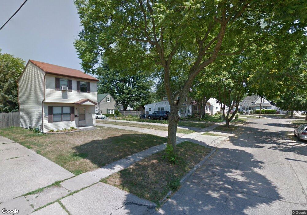
2544 Westbrook Dr Toledo, OH 43613
DeVeaux NeighborhoodEstimated Value: $98,223 - $114,000
2
Beds
1
Bath
720
Sq Ft
$148/Sq Ft
Est. Value
About This Home
This home is located at 2544 Westbrook Dr, Toledo, OH 43613 and is currently estimated at $106,556, approximately $147 per square foot. 2544 Westbrook Dr is a home located in Lucas County with nearby schools including Elmhurst Elementary School, Start High School, and Horizon Science Academy - Toledo High School.
Ownership History
Date
Name
Owned For
Owner Type
Purchase Details
Closed on
Jan 31, 2007
Sold by
Paschall M
Bought by
Shenofsky David R and Shenofsky Rose M
Current Estimated Value
Purchase Details
Closed on
Nov 15, 2006
Sold by
Wallace Kathleen M
Bought by
Pachall M and 2544 Westbrook Trust
Purchase Details
Closed on
Aug 30, 2001
Sold by
Wolin Craig T and Wolin Laura A
Bought by
Wallace Kathleen M
Purchase Details
Closed on
Dec 9, 1988
Sold by
Miller Charles E and E G
Create a Home Valuation Report for This Property
The Home Valuation Report is an in-depth analysis detailing your home's value as well as a comparison with similar homes in the area
Home Values in the Area
Average Home Value in this Area
Purchase History
| Date | Buyer | Sale Price | Title Company |
|---|---|---|---|
| Shenofsky David R | $42,000 | Metro Title Agency Inc | |
| Pachall M | -- | None Available | |
| Wallace Kathleen M | $50,000 | -- | |
| -- | $19,500 | -- |
Source: Public Records
Tax History Compared to Growth
Tax History
| Year | Tax Paid | Tax Assessment Tax Assessment Total Assessment is a certain percentage of the fair market value that is determined by local assessors to be the total taxable value of land and additions on the property. | Land | Improvement |
|---|---|---|---|---|
| 2024 | $616 | $19,040 | $4,130 | $14,910 |
| 2023 | $1,052 | $15,365 | $3,395 | $11,970 |
| 2022 | $1,051 | $15,365 | $3,395 | $11,970 |
| 2021 | $1,074 | $15,365 | $3,395 | $11,970 |
| 2020 | $1,024 | $12,810 | $2,835 | $9,975 |
| 2019 | $999 | $12,810 | $2,835 | $9,975 |
| 2018 | $1,004 | $12,810 | $2,835 | $9,975 |
| 2017 | $956 | $11,620 | $3,220 | $8,400 |
| 2016 | $961 | $33,200 | $9,200 | $24,000 |
| 2015 | $953 | $33,200 | $9,200 | $24,000 |
| 2014 | $751 | $11,620 | $3,220 | $8,400 |
| 2013 | $751 | $11,620 | $3,220 | $8,400 |
Source: Public Records
Map
Nearby Homes
- 2640 Westbrook Dr
- 2513 Grantwood Dr
- 2645 Westbrook Dr
- 2409 Lambert Dr
- 4440 Woodmont Rd
- 2408 Lambert Dr
- 2645 Grantwood Dr
- 2659 Oak Grove Place
- 4220 Douglas Rd
- 2728 Castleton Ave
- 2316 Westbrook Dr
- 4128 Douglas Rd
- 2605 Wyndale Rd
- 4210 Bowen Rd
- 2855 Castleton Ave
- 2842 Oak Grove Place
- 4250 Garrison Rd
- 2310 Tremainsville Rd
- 3951 Buell Ave
- 4318 Bellevue Rd
- 2550 Westbrook Dr
- 2546 Westbrook Dr
- 2540 Westbrook Dr
- 2552 Westbrook Dr
- 2536 Westbrook Dr
- 2554 Westbrook Dr
- 2537 Lambert Dr
- 2539 Lambert Dr
- 2533 Lambert Dr
- 2543 Lambert Dr
- 2534 Westbrook Dr
- 2529 Lambert Dr
- 2556 Westbrook Dr
- 2549 Lambert Dr
- 2543 Westbrook Dr
- 2547 Westbrook Dr
- 2525 Lambert Dr
- 4341 Yellowstone Dr
- 2553 Lambert Dr
- 2549 Westbrook Dr