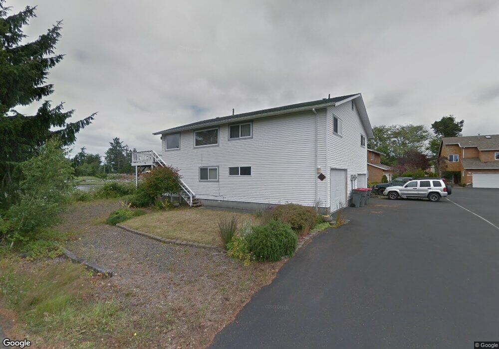
2549 Queen St Unit 1 Seaside, OR 97138
Estimated Value: $510,000 - $719,000
4
Beds
3
Baths
3,410
Sq Ft
$181/Sq Ft
Est. Value
About This Home
This home is located at 2549 Queen St Unit 1, Seaside, OR 97138 and is currently estimated at $617,933, approximately $181 per square foot. 2549 Queen St Unit 1 is a home located in Clatsop County with nearby schools including Seaside High School.
Ownership History
Date
Name
Owned For
Owner Type
Purchase Details
Closed on
Jun 21, 2017
Sold by
Millikan Ron
Bought by
Clouse Dylan and Clouse Kansys
Current Estimated Value
Home Financials for this Owner
Home Financials are based on the most recent Mortgage that was taken out on this home.
Original Mortgage
$358,388
Outstanding Balance
$293,009
Interest Rate
3.5%
Mortgage Type
FHA
Estimated Equity
$324,924
Purchase Details
Closed on
Jul 1, 2014
Sold by
Millikan Ben and Millikan Eva
Bought by
Millikan Living Trust
Purchase Details
Closed on
Sep 22, 2010
Sold by
Millikan Ben W and Millikan Eva M
Bought by
Millikan Ben W and Millikan Eva M
Create a Home Valuation Report for This Property
The Home Valuation Report is an in-depth analysis detailing your home's value as well as a comparison with similar homes in the area
Purchase History
| Date | Buyer | Sale Price | Title Company |
|---|---|---|---|
| Clouse Dylan | $365,000 | Ticor Title Company Of Or | |
| Millikan Living Trust | -- | None Available | |
| Millikan Ben W | -- | None Available |
Source: Public Records
Mortgage History
| Date | Status | Borrower | Loan Amount |
|---|---|---|---|
| Open | Clouse Dylan | $358,388 |
Source: Public Records
Tax History
| Year | Tax Paid | Tax Assessment Tax Assessment Total Assessment is a certain percentage of the fair market value that is determined by local assessors to be the total taxable value of land and additions on the property. | Land | Improvement |
|---|---|---|---|---|
| 2025 | $6,338 | $441,031 | -- | -- |
| 2024 | $6,151 | $428,186 | -- | -- |
| 2023 | $5,969 | $415,715 | $0 | $0 |
| 2022 | $5,807 | $403,608 | $0 | $0 |
| 2021 | $5,683 | $391,854 | $0 | $0 |
| 2020 | $5,551 | $380,442 | $0 | $0 |
| 2019 | $5,271 | $369,362 | $0 | $0 |
Source: Public Records
Map
Nearby Homes
- 802 25th Ave
- 2674 U S 101
- 2440 Pine St
- 0 Cross Creek St Unit 12
- 0 Cross Creek St Unit 10
- 0 Cross Creek St Unit 11
- 0 Cross Creek St Unit 26-112
- 0 Cross Creek St Unit 13
- 0 Cross Creek St Unit 26-114
- 0 Cross Creek St Unit 26-115
- 0 Cross Creek St Unit 26-116
- 0 Cross Creek St Unit 14
- 0 Cross Creek St Unit 26-117
- 2657 N Hwy 101 Unit 6
- 2550 Boehm Acres Rd
- 782 Woodland Ct
- 934 H St
- 790 17th Ave
- 1265 D St
- 2110 Thompson Falls Dr
- 2549 Queen St
- 2549 Queen St Unit 1 & 2
- 2549 Queen Unit 1 & 2
- 2549 Queen 1 & 2
- 2549 Queen #1 & 2
- 2549 Queen 1 - 2 St
- 2549 Queen 1-2 St
- 2549 Queen 1 - 2 St
- 2547 Queen St
- 2543 Queen St
- 2535 Queen St
- 2537 Queen St
- 2556 Queen St
- 2541 Queen St
- 2525 Queen St
- 2539 Queen St
- 2532 Queen St
- 2533 Queen St
- 905 26th Ave
- 2531 Queen St
Your Personal Tour Guide
Ask me questions while you tour the home.