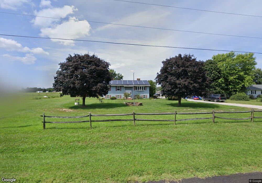
255 Hering Rd Milford, DE 19963
Estimated Value: $300,000 - $352,000
3
Beds
2
Baths
3,000
Sq Ft
$110/Sq Ft
Est. Value
About This Home
This home is located at 255 Hering Rd, Milford, DE 19963 and is currently estimated at $328,649, approximately $109 per square foot. 255 Hering Rd is a home located in Kent County with nearby schools including Benjamin Banneker Elementary School, Milford Central Academy, and Milford Senior High School.
Ownership History
Date
Name
Owned For
Owner Type
Purchase Details
Closed on
Nov 16, 2016
Sold by
Lawrence J Houser
Bought by
Mankin Bonnie and Mankin Dean
Current Estimated Value
Home Financials for this Owner
Home Financials are based on the most recent Mortgage that was taken out on this home.
Original Mortgage
$199,500
Outstanding Balance
$160,917
Interest Rate
3.57%
Estimated Equity
$167,732
Purchase Details
Closed on
Aug 1, 1988
Bought by
Houser Lawrence J
Create a Home Valuation Report for This Property
The Home Valuation Report is an in-depth analysis detailing your home's value as well as a comparison with similar homes in the area
Home Values in the Area
Average Home Value in this Area
Purchase History
| Date | Buyer | Sale Price | Title Company |
|---|---|---|---|
| Mankin Bonnie | -- | -- | |
| Houser Lawrence J | $91,000 | -- |
Source: Public Records
Mortgage History
| Date | Status | Borrower | Loan Amount |
|---|---|---|---|
| Open | Mankin Bonnie | $199,500 | |
| Closed | Mankin Bonnie | -- |
Source: Public Records
Tax History Compared to Growth
Tax History
| Year | Tax Paid | Tax Assessment Tax Assessment Total Assessment is a certain percentage of the fair market value that is determined by local assessors to be the total taxable value of land and additions on the property. | Land | Improvement |
|---|---|---|---|---|
| 2025 | $1,256 | $333,200 | $86,600 | $246,600 |
| 2024 | $1,256 | $333,200 | $86,600 | $246,600 |
| 2023 | $1,045 | $46,500 | $8,500 | $38,000 |
| 2022 | $1,021 | $46,500 | $8,500 | $38,000 |
| 2021 | $1,039 | $46,500 | $8,500 | $38,000 |
| 2020 | $1,047 | $46,500 | $8,500 | $38,000 |
| 2019 | $1,052 | $46,500 | $8,500 | $38,000 |
| 2018 | $1,079 | $47,500 | $8,500 | $39,000 |
| 2017 | $0 | $47,500 | $0 | $0 |
| 2016 | $1,156 | $47,500 | $0 | $0 |
| 2015 | $846 | $47,500 | $0 | $0 |
| 2014 | $829 | $47,500 | $0 | $0 |
Source: Public Records
Map
Nearby Homes
- 1700 Thompsonville Rd
- 237 Thompsonville Rd
- 1006 Bay Rd
- 2095 Reynolds Rd
- 695 Cicada Ln
- 1082 Road 402
- 2367 Bay Rd
- 285 Shore Ln
- 607 Milford Neck Rd
- 13 Shore Ln
- 3338 Bay Rd
- 0 New Wharf Rd
- 600 NE 10th St
- 103 Alexa Ct
- 120 N Landing Dr
- 256 S Landing Dr
- 425 Greenbrook Dr
- 497 Greenbrook Dr
- 803 N Washington St
- 823 Greenbrook Dr
- 289 Hering Rd
- 219 Hering Rd
- 311 Hering Rd
- 165 Hering Rd
- 343 Hering Rd
- 000 Hering Rd
- 399 Hering Rd
- 441 Hering Rd
- 5471 Big Stone Beach Rd
- 5471 Big Stone Beach Rd
- 5101 Big Stone Beach Rd
- 5395 Big Stone Beach Rd
- 539 Hering Rd
- 5121 Big Stone Beach Rd
- 5367 Big Stone Beach Rd
- 5135 Big Stone Beach Rd
- 559 Hering Rd
- 5187 Big Stone Beach Rd
- 5432 Big Stone Beach Rd Unit 2
- 5432 Big Stone Beach Rd