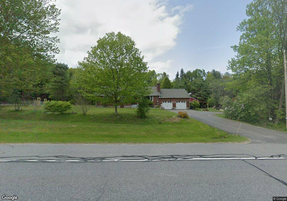
2557 Route 29 Unit NYS Middle Grove, NY 12850
Estimated Value: $430,000 - $515,000
3
Beds
2
Baths
1,930
Sq Ft
$239/Sq Ft
Est. Value
About This Home
This home is located at 2557 Route 29 Unit NYS, Middle Grove, NY 12850 and is currently estimated at $461,136, approximately $238 per square foot. 2557 Route 29 Unit NYS is a home located in Saratoga County with nearby schools including Joseph Henry Elementary School and Galway Junior/Senior High School.
Ownership History
Date
Name
Owned For
Owner Type
Purchase Details
Closed on
Sep 23, 2022
Sold by
Scott James V and Scott Marilyn J
Bought by
Smith Holene and Smith Roy D
Current Estimated Value
Home Financials for this Owner
Home Financials are based on the most recent Mortgage that was taken out on this home.
Original Mortgage
$342,000
Interest Rate
6.29%
Mortgage Type
Purchase Money Mortgage
Purchase Details
Closed on
Aug 5, 2005
Sold by
Scott Marilyn Jean
Bought by
Scott Marilyn Jean
Purchase Details
Closed on
Apr 16, 1999
Create a Home Valuation Report for This Property
The Home Valuation Report is an in-depth analysis detailing your home's value as well as a comparison with similar homes in the area
Home Values in the Area
Average Home Value in this Area
Purchase History
| Date | Buyer | Sale Price | Title Company |
|---|---|---|---|
| Smith Holene | $360,000 | None Available | |
| Scott Marilyn Jean | -- | James P Craig Esq | |
| -- | -- | -- |
Source: Public Records
Mortgage History
| Date | Status | Borrower | Loan Amount |
|---|---|---|---|
| Previous Owner | Smith Holene | $342,000 |
Source: Public Records
Tax History Compared to Growth
Tax History
| Year | Tax Paid | Tax Assessment Tax Assessment Total Assessment is a certain percentage of the fair market value that is determined by local assessors to be the total taxable value of land and additions on the property. | Land | Improvement |
|---|---|---|---|---|
| 2024 | $6,376 | $324,000 | $38,500 | $285,500 |
| 2023 | $6,378 | $324,000 | $38,500 | $285,500 |
| 2022 | $1,276 | $297,000 | $38,500 | $258,500 |
| 2021 | $1,276 | $297,000 | $38,500 | $258,500 |
| 2020 | $1,276 | $297,000 | $38,500 | $258,500 |
| 2018 | $5,742 | $174,900 | $20,300 | $154,600 |
| 2017 | $5,503 | $174,900 | $20,300 | $154,600 |
| 2016 | $1,168 | $174,900 | $20,300 | $154,600 |
Source: Public Records
Map
Nearby Homes
- 2868 New York 29
- 6107 Parkis Mills Rd
- 6628 Middle Grove Rd
- 108 La Flamme Rd
- L64 Antioch Rd
- 5671 Parkis Mills Rd
- 2537 Old Mill Rd
- 106 Fay Ln
- L51.2 Sherman Rd
- 20 Lester Ln
- L43.1 Hinds Rd
- 547 Middle Grove Rd
- 51 Creekside Dr
- 6307 Greens Corner Rd
- 44 Creekside Dr
- 42 Creekside Dr
- 40 Creekside Dr
- 5623 Lake Rd
- 34 Creekside Dr
- L23.3 Potter Hollow Rd
- 2557 Route 29
- 2558 New York 29
- 2558 Route 29 Unit NYS
- 2546 Route 29 Unit NYS
- 2546 Route 29
- 2539 Route 29 Unit NYS
- 0 Nys Rte 29 Unit 11069875
- 0 Nys Rte 29 Unit 202215704
- 2539 New York 29
- 2459 New York 29
- 2459 Route 29 Unit NYS
- 2518 Route 29 Unit NYS
- 2611 Route 29 Unit NYS
- 2608 Route 29 Unit NYS
- 7319 Bills Rd
- 2620 Route 29
- 2633 Route 29 Unit NYS
- 2653 Route 29 Unit NYS
- 2598 North Rd
- 2653 New York 29