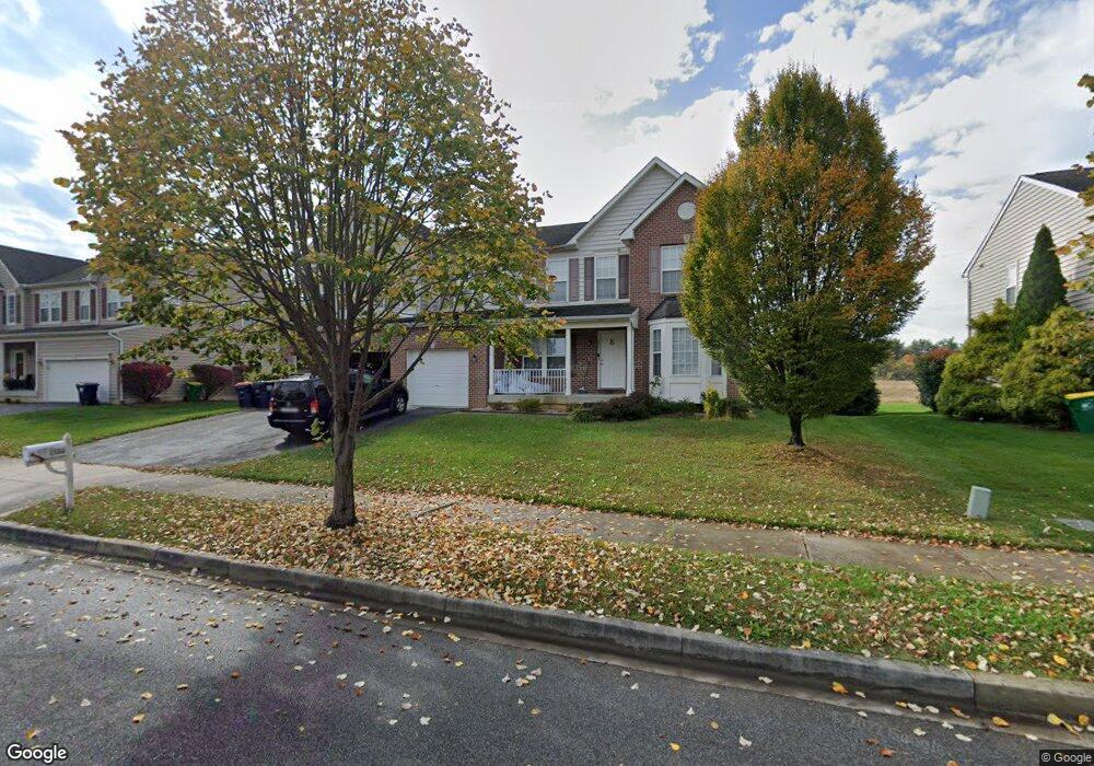
256 Bucktail Dr Middletown, DE 19709
Estimated Value: $646,000 - $741,000
5
Beds
5
Baths
4,176
Sq Ft
$171/Sq Ft
Est. Value
About This Home
This home is located at 256 Bucktail Dr, Middletown, DE 19709 and is currently estimated at $712,322, approximately $170 per square foot. 256 Bucktail Dr is a home located in New Castle County with nearby schools including Brick Mill Elementary School, Louis L. Redding Middle School, and Middletown High School.
Ownership History
Date
Name
Owned For
Owner Type
Purchase Details
Closed on
Aug 24, 2022
Sold by
Enoch Usenbor
Bought by
Usenbor Peace and Brown Sethlina
Current Estimated Value
Purchase Details
Closed on
Jun 15, 2005
Sold by
The Ryland Group Inc
Bought by
Peace Usenbor Enoch and Peace Osamaguoghomwenwi
Home Financials for this Owner
Home Financials are based on the most recent Mortgage that was taken out on this home.
Original Mortgage
$313,050
Interest Rate
5.45%
Mortgage Type
Fannie Mae Freddie Mac
Purchase Details
Closed on
Dec 13, 2004
Sold by
299 Associates Llc
Bought by
The Ryland Group Inc
Create a Home Valuation Report for This Property
The Home Valuation Report is an in-depth analysis detailing your home's value as well as a comparison with similar homes in the area
Home Values in the Area
Average Home Value in this Area
Purchase History
| Date | Buyer | Sale Price | Title Company |
|---|---|---|---|
| Usenbor Peace | -- | None Listed On Document | |
| Peace Usenbor Enoch | $391,314 | -- | |
| The Ryland Group Inc | $170,000 | -- |
Source: Public Records
Mortgage History
| Date | Status | Borrower | Loan Amount |
|---|---|---|---|
| Previous Owner | Peace Usenbor Enoch | $313,050 |
Source: Public Records
Tax History
| Year | Tax Paid | Tax Assessment Tax Assessment Total Assessment is a certain percentage of the fair market value that is determined by local assessors to be the total taxable value of land and additions on the property. | Land | Improvement |
|---|---|---|---|---|
| 2024 | $450 | $150,000 | $15,000 | $135,000 |
| 2023 | $450 | $150,000 | $15,000 | $135,000 |
| 2022 | $4,612 | $150,000 | $15,000 | $135,000 |
| 2021 | $4,511 | $150,000 | $15,000 | $135,000 |
| 2020 | $4,458 | $150,000 | $15,000 | $135,000 |
| 2019 | $4,581 | $150,000 | $15,000 | $135,000 |
| 2018 | $3,954 | $150,000 | $15,000 | $135,000 |
| 2017 | $450 | $150,000 | $15,000 | $135,000 |
| 2016 | $3,869 | $150,000 | $15,000 | $135,000 |
| 2015 | $3,757 | $150,000 | $15,000 | $135,000 |
| 2014 | $3,748 | $150,000 | $15,000 | $135,000 |
Source: Public Records
Map
Nearby Homes
- 624 Nesting Ln
- 40 S Cummings Dr
- 29 W Reybold Dr
- 60 S Cummings Dr
- 403 New St
- 836 Sweet Birch Dr
- 408 Quincy Ave
- 8 Redding Cir
- 659 Warren Dr
- 3 Redding Cir
- 187 Gillespie Ave
- 795 Idlewyld Dr
- 815 Sweet Birch Dr
- 129 E Main St
- 113 Crawford St
- 945 Lansdowne Rd
- 610 Spring Hollow Dr
- 108 E Cochran St
- 102 E Redding St
- 167 Springfield Cir
- 254 Bucktail Dr
- 258 Bucktail Dr
- 260 Bucktail Dr
- 252 Bucktail Dr
- 257 Bucktail Dr
- 255 Bucktail Dr
- 259 Bucktail Dr
- 251 Bucktail Dr
- 262 Bucktail Dr
- 301 Autumn Ct
- 250 Bucktail Dr
- 406 Estate Dr
- 303 Autumn Ct
- 264 Bucktail Dr
- 404 Estate Dr
- 404 Estate Dr Unit 200
- 408 Estate Dr
- 245 Bucktail Dr
- 246 Bucktail Dr
- 305 Autumn Ct
Your Personal Tour Guide
Ask me questions while you tour the home.