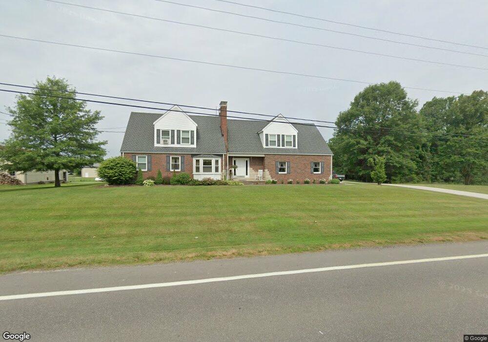
2561 State Route 44 Rootstown, OH 44272
Estimated Value: $341,000 - $364,903
3
Beds
3
Baths
2,653
Sq Ft
$133/Sq Ft
Est. Value
About This Home
This home is located at 2561 State Route 44, Rootstown, OH 44272 and is currently estimated at $353,476, approximately $133 per square foot. 2561 State Route 44 is a home located in Portage County with nearby schools including Waterloo Elementary School, Waterloo Middle School, and Waterloo High School.
Ownership History
Date
Name
Owned For
Owner Type
Purchase Details
Closed on
May 23, 2003
Sold by
Pavliga Frank M and Pavliga Gail K
Bought by
Hensley Jason and Hensley Tara
Current Estimated Value
Home Financials for this Owner
Home Financials are based on the most recent Mortgage that was taken out on this home.
Original Mortgage
$135,375
Outstanding Balance
$59,308
Interest Rate
5.9%
Mortgage Type
Purchase Money Mortgage
Estimated Equity
$294,168
Purchase Details
Closed on
Oct 23, 1989
Bought by
Nichols Eric Paul
Create a Home Valuation Report for This Property
The Home Valuation Report is an in-depth analysis detailing your home's value as well as a comparison with similar homes in the area
Home Values in the Area
Average Home Value in this Area
Purchase History
| Date | Buyer | Sale Price | Title Company |
|---|---|---|---|
| Hensley Jason | $142,500 | Approved Statewide Title Age | |
| Nichols Eric Paul | $55,000 | -- |
Source: Public Records
Mortgage History
| Date | Status | Borrower | Loan Amount |
|---|---|---|---|
| Open | Hensley Jason | $135,375 |
Source: Public Records
Tax History Compared to Growth
Tax History
| Year | Tax Paid | Tax Assessment Tax Assessment Total Assessment is a certain percentage of the fair market value that is determined by local assessors to be the total taxable value of land and additions on the property. | Land | Improvement |
|---|---|---|---|---|
| 2024 | $4,512 | $117,220 | $15,790 | $101,430 |
| 2023 | $3,831 | $84,740 | $12,150 | $72,590 |
| 2022 | $3,926 | $84,740 | $12,150 | $72,590 |
| 2021 | $3,936 | $84,740 | $12,150 | $72,590 |
| 2020 | $3,264 | $72,630 | $12,150 | $60,480 |
| 2019 | $3,288 | $72,630 | $12,150 | $60,480 |
| 2018 | $2,837 | $62,480 | $9,100 | $53,380 |
| 2017 | $2,837 | $62,480 | $9,100 | $53,380 |
| 2016 | $2,829 | $62,480 | $9,100 | $53,380 |
| 2015 | $2,862 | $62,480 | $9,100 | $53,380 |
| 2014 | $2,813 | $59,470 | $9,100 | $50,370 |
| 2013 | $2,725 | $59,470 | $9,100 | $50,370 |
Source: Public Records
Map
Nearby Homes
- 3021 Hartville Rd
- 2236 Hartville Rd
- 3637 Old Forge Rd
- 2071 Hartville Rd
- 4324 Abbey Ln
- 4958 Bassett Rd
- 2322 New Milford Rd
- 2113 New Milford Rd
- 1480 State Route 44
- 3401 Waterloo Rd
- 3401 Biltz Rd
- 1291 State Route 44
- 4759 Alexander Rd
- 2547 Industry Rd
- 0 Rootstown Rd Unit 5173350
- 5560 Wilkes Rd
- 3987 J A Vaughn Ave
- 1026 Hartville Rd N
- 3275 Ranfield Rd
- 3807 Industry Rd
- 2571 State Route 44
- 2564 Ohio 44
- 2564 State Route 44
- 2607 State Route 44
- 2604 State Route 44
- V/L Bassett Rd
- 2479 State Route 44
- 2624 State Route 44
- Lot 95 State Route 44 (2 5 Ac)
- 2701 State Route 44
- 85 & 95 State Route 44 (112 74 Ac)
- 2477 State Route 44
- 3951 Bassett Rd
- 3921 Bassett Rd
- 2670 State Route 44
- 2462 State Route 44
- 3905 Bassett Rd
- 3898 Bassett Rd
- 2465 State Route 44
- 3891 Bassett Rd