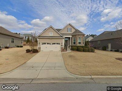
2566 Beckwith Rd Apex, NC 27523
Green Level NeighborhoodEstimated Value: $881,048 - $977,000
--
Bed
--
Bath
2,758
Sq Ft
$341/Sq Ft
Est. Value
About This Home
This home is located at 2566 Beckwith Rd, Apex, NC 27523 and is currently estimated at $940,262, approximately $340 per square foot. 2566 Beckwith Rd is a home with nearby schools including White Oak Elementary School, Mills Park Middle School, and Green Level High School.
Ownership History
Date
Name
Owned For
Owner Type
Purchase Details
Closed on
Mar 27, 2018
Sold by
Monroe Dennis Rodney and Monroe Carol Jean
Bought by
Monroe Dennis Rodney and Monroe Carol Jean
Current Estimated Value
Purchase Details
Closed on
Sep 28, 2016
Sold by
Toll Nc Ii Lp
Bought by
Monroe Dennis R and Monroe Carol J
Home Financials for this Owner
Home Financials are based on the most recent Mortgage that was taken out on this home.
Original Mortgage
$400,000
Outstanding Balance
$327,487
Interest Rate
3.46%
Mortgage Type
New Conventional
Estimated Equity
$617,186
Create a Home Valuation Report for This Property
The Home Valuation Report is an in-depth analysis detailing your home's value as well as a comparison with similar homes in the area
Home Values in the Area
Average Home Value in this Area
Purchase History
| Date | Buyer | Sale Price | Title Company |
|---|---|---|---|
| Monroe Dennis Rodney | -- | None Available | |
| Monroe Dennis R | $555,000 | None Available |
Source: Public Records
Mortgage History
| Date | Status | Borrower | Loan Amount |
|---|---|---|---|
| Open | Monroe Dennis R | $400,000 |
Source: Public Records
Tax History Compared to Growth
Tax History
| Year | Tax Paid | Tax Assessment Tax Assessment Total Assessment is a certain percentage of the fair market value that is determined by local assessors to be the total taxable value of land and additions on the property. | Land | Improvement |
|---|---|---|---|---|
| 2024 | $6,707 | $783,522 | $225,000 | $558,522 |
| 2023 | $6,338 | $575,946 | $145,000 | $430,946 |
| 2022 | $5,949 | $575,946 | $145,000 | $430,946 |
| 2021 | $5,722 | $575,946 | $145,000 | $430,946 |
| 2020 | $5,874 | $597,327 | $145,000 | $452,327 |
| 2019 | $6,167 | $541,239 | $175,000 | $366,239 |
| 2018 | $5,808 | $541,239 | $175,000 | $366,239 |
| 2017 | $5,405 | $541,239 | $175,000 | $366,239 |
Source: Public Records
Map
Nearby Homes
- 2613 Beckwith Rd
- 2633 Beckwith Rd
- 2554 Club Level Dr
- 2421 Beckwith Rd
- 2577 Silas Peak Ln
- 7723 Roberts Rd
- 2590 Silas Peak Ln
- 107 Ludbrook Ct
- 2525 Silas Peak Ln
- 2506 Silas Peak Ln
- 241 Fishburn Dr
- 508 White Oak Branch Ln
- 2737 Willow Rock Ln
- 1121 White Oak Creek Dr
- 337 Parlier Dr
- 333 Parlier Dr
- 1408 Old Ivey Rd
- 428 Parlier Dr
- 155 Annabelle Branch Ln
- 518 Parlier Dr Unit 82
- 2566 Beckwith Rd
- 2600 Beckwith Rd
- 2560 Beckwith Rd
- 2604 Beckwith Rd
- 2554 Beckwith Rd
- 2563 Club Level Dr
- 2545 Club Level Dr
- 2561 Beckwith Rd
- 2601 Beckwith Rd
- 2569 Club Level Dr
- 2539 Club Level Dr
- 2555 Beckwith Rd
- 2608 Beckwith Rd
- 2546 Beckwith Rd
- 2533 Club Level Dr
- 2607 Beckwith Rd
- 2575 Club Level Dr
- 2549 Beckwith Rd
- 2622 Range Overlook Crossing
- 2581 Club Level Dr
