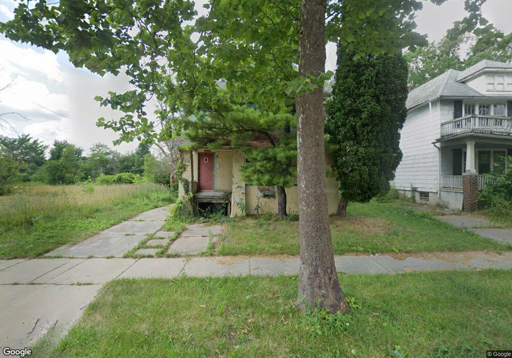
2567 Ashland St Detroit, MI 48215
Riverbend NeighborhoodEstimated Value: $84,000 - $141,000
3
Beds
1
Bath
1,335
Sq Ft
$84/Sq Ft
Est. Value
About This Home
This home is located at 2567 Ashland St, Detroit, MI 48215 and is currently estimated at $112,726, approximately $84 per square foot. 2567 Ashland St is a home located in Wayne County with nearby schools including Carstens Academy of Aquatic Science, Edward 'Duke' Ellington Conservatory of Music and Art, and Charles L. Spain Elementary-Middle School.
Ownership History
Date
Name
Owned For
Owner Type
Purchase Details
Closed on
Jan 13, 2016
Sold by
Wayne County Treasurer
Bought by
Detroit Land Bank Authority
Current Estimated Value
Purchase Details
Closed on
May 25, 2011
Sold by
Secretary Of Housing & Urban Development
Bought by
Johnson Ricky L and Johnson Tenetia A
Purchase Details
Closed on
Mar 4, 2011
Sold by
U S Bank National Association
Bought by
Secretary Of Housing & Urban Development
Purchase Details
Closed on
May 26, 2010
Sold by
Williams Janet
Bought by
Us Bank National Association
Create a Home Valuation Report for This Property
The Home Valuation Report is an in-depth analysis detailing your home's value as well as a comparison with similar homes in the area
Home Values in the Area
Average Home Value in this Area
Purchase History
| Date | Buyer | Sale Price | Title Company |
|---|---|---|---|
| Detroit Land Bank Authority | -- | None Available | |
| Johnson Ricky L | $350 | None Available | |
| Secretary Of Housing & Urban Development | -- | None Available | |
| Us Bank National Association | $38,481 | None Available |
Source: Public Records
Tax History Compared to Growth
Tax History
| Year | Tax Paid | Tax Assessment Tax Assessment Total Assessment is a certain percentage of the fair market value that is determined by local assessors to be the total taxable value of land and additions on the property. | Land | Improvement |
|---|---|---|---|---|
| 2025 | $918 | $12,700 | $0 | $0 |
| 2024 | $918 | $11,400 | $0 | $0 |
| 2023 | $999 | $12,700 | $0 | $0 |
| 2022 | -- | $0 | $0 | $0 |
| 2021 | $0 | $0 | $0 | $0 |
| 2020 | $451 | $0 | $0 | $0 |
| 2019 | $451 | $0 | $0 | $0 |
| 2018 | $0 | $0 | $0 | $0 |
| 2017 | $190 | $0 | $0 | $0 |
| 2016 | $240 | $1,900 | $0 | $0 |
| 2015 | $190 | $1,900 | $0 | $0 |
| 2013 | $216 | $2,158 | $0 | $0 |
| 2010 | -- | $3,164 | $622 | $2,542 |
Source: Public Records
Map
Nearby Homes
- 1324 Wayburn St
- 1316 Maryland St
- 2966 Ashland St
- 1318 Maryland St
- 2140 Alter Rd
- 1447 Wayburn St
- 1449 Wayburn St
- 2568 Alter Rd
- 1465 Maryland St
- 1417 Beaconsfield Ave
- 2950 Lakewood St
- 1306 Beaconsfield Ave Unit 1308
- 3064 Marlborough St
- 2651 Lakewood St
- 1254 Beaconsfield Ave
- 14345 Kercheval St
- 395 Chalmers St
- 3080 Marlborough St
- 1451 Beaconsfield Ave
- 1308 Ashland St
- 2575 Ashland St
- 2581 Ashland St
- 2545 Ashland St
- 2587 Ashland St
- 2572 Manistique St
- 2564 Ashland St
- 2576 Manistique St
- 2568 Ashland St
- 2576 Ashland St
- 2556 Ashland St
- 2540 Manistique St
- 2586 Ashland St
- 2592 Ashland St
- 2521 Ashland St
- 2534 Manistique St
- 2608 Manistique St
- 2530 Manistique St
- 2598 Ashland St
- 2611 Ashland St
- 2515 Ashland St