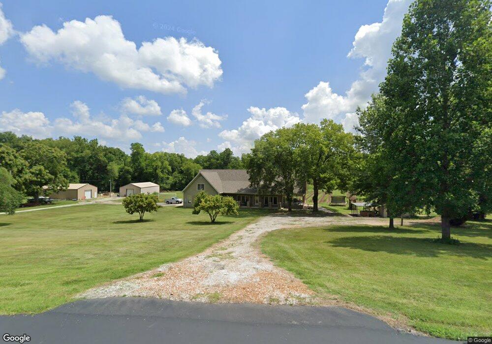
2568 Oak Dr O Fallon, MO 63368
Estimated Value: $562,000 - $636,000
3
Beds
3
Baths
2,799
Sq Ft
$213/Sq Ft
Est. Value
About This Home
This home is located at 2568 Oak Dr, O Fallon, MO 63368 and is currently estimated at $595,039, approximately $212 per square foot. 2568 Oak Dr is a home located in St. Charles County with nearby schools including Discovery Ridge Elementary School, Frontier Middle School, and Liberty High School.
Ownership History
Date
Name
Owned For
Owner Type
Purchase Details
Closed on
Jun 11, 2018
Sold by
Montgomery Roger and Montgomery Cathy
Bought by
Montgomery Rober and Montgomery Cathy
Current Estimated Value
Purchase Details
Closed on
May 11, 2018
Sold by
Montgomery Roger and Montgomery Cathy
Bought by
Montgomery Roger and Montgomery Cathy
Purchase Details
Closed on
Dec 21, 2015
Sold by
Montgomery Richard and Montgomery Sally
Bought by
Montgomery Roger and Montgomery Catherine
Purchase Details
Closed on
Feb 4, 1999
Sold by
Montgomery Roger and Montgomery Orville
Bought by
Montgomery Richard and Montgomery Sally
Create a Home Valuation Report for This Property
The Home Valuation Report is an in-depth analysis detailing your home's value as well as a comparison with similar homes in the area
Home Values in the Area
Average Home Value in this Area
Purchase History
| Date | Buyer | Sale Price | Title Company |
|---|---|---|---|
| Montgomery Rober | -- | None Available | |
| Montgomery Roger | -- | None Available | |
| Montgomery Roger | -- | None Available | |
| Montgomery Richard | $32,500 | -- |
Source: Public Records
Tax History
| Year | Tax Paid | Tax Assessment Tax Assessment Total Assessment is a certain percentage of the fair market value that is determined by local assessors to be the total taxable value of land and additions on the property. | Land | Improvement |
|---|---|---|---|---|
| 2025 | $5,161 | $92,919 | -- | -- |
| 2023 | $5,161 | $80,964 | $0 | $0 |
| 2022 | $4,916 | $71,965 | $0 | $0 |
| 2021 | $4,921 | $71,965 | $0 | $0 |
| 2020 | $4,644 | $65,121 | $0 | $0 |
| 2019 | $4,312 | $65,121 | $0 | $0 |
| 2018 | $4,137 | $59,512 | $0 | $0 |
| 2017 | $4,136 | $59,512 | $0 | $0 |
| 2016 | $4,138 | $57,051 | $0 | $0 |
| 2015 | $4,056 | $57,051 | $0 | $0 |
| 2014 | $3,615 | $54,564 | $0 | $0 |
Source: Public Records
Map
Nearby Homes
- 109 Pinto Cir
- 134 Pinto Cir
- 141 Cardow Dr
- 837 Memsie Dr
- 558 Springhurst Pkwy
- 821 Memsie Dr
- 9045 Highway Dd
- 717 Southerland Dr
- 409 Roddens Way
- 157 Cardow Dr
- Danville Plan at The Streets of Caledonia - Maple Street Collection
- Calvin Plan at The Streets of Caledonia - Designer Collection
- Cumberland Plan at The Streets of Caledonia - Maple Street Collection
- Leland Plan at The Streets of Caledonia - Masterpiece Collection
- Wyatt Plan at The Streets of Caledonia - Designer Collection
- Stanton Plan at The Streets of Caledonia - Masterpiece Collection
- Winslow Plan at The Streets of Caledonia - Masterpiece Collection
- Finley Plan at The Streets of Caledonia - Masterpiece Collection
- Paxton Plan at The Streets of Caledonia - Masterpiece Collection
- Clay Plan at The Streets of Caledonia - Masterpiece Collection
Your Personal Tour Guide
Ask me questions while you tour the home.