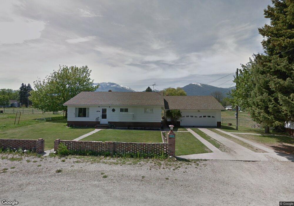
257 Cedar St Hamilton, MT 59840
Estimated Value: $449,365 - $510,000
3
Beds
2
Baths
1,240
Sq Ft
$380/Sq Ft
Est. Value
About This Home
This home is located at 257 Cedar St, Hamilton, MT 59840 and is currently estimated at $471,341, approximately $380 per square foot. 257 Cedar St is a home with nearby schools including Hamilton High School and Hamilton Christian Academy.
Ownership History
Date
Name
Owned For
Owner Type
Purchase Details
Closed on
Jul 17, 2022
Sold by
Nd Ventures Llc
Bought by
Burge Thomas and Burge Harley
Current Estimated Value
Purchase Details
Closed on
Nov 16, 2018
Sold by
N D Ventures Llc
Bought by
Burge Thomas and Burge Harley
Home Financials for this Owner
Home Financials are based on the most recent Mortgage that was taken out on this home.
Original Mortgage
$139,473
Interest Rate
3.5%
Mortgage Type
FHA
Create a Home Valuation Report for This Property
The Home Valuation Report is an in-depth analysis detailing your home's value as well as a comparison with similar homes in the area
Home Values in the Area
Average Home Value in this Area
Purchase History
| Date | Buyer | Sale Price | Title Company |
|---|---|---|---|
| Burge Thomas | $7,500 | None Listed On Document | |
| Burge Thomas | $140,868 | Other |
Source: Public Records
Mortgage History
| Date | Status | Borrower | Loan Amount |
|---|---|---|---|
| Previous Owner | Burge Thomas | $139,473 | |
| Closed | Burge Thomas | $34,900 |
Source: Public Records
Tax History
| Year | Tax Paid | Tax Assessment Tax Assessment Total Assessment is a certain percentage of the fair market value that is determined by local assessors to be the total taxable value of land and additions on the property. | Land | Improvement |
|---|---|---|---|---|
| 2025 | $1,218 | $379,300 | $0 | $0 |
| 2024 | $1,720 | $304,400 | $0 | $0 |
| 2023 | $1,810 | $304,400 | $0 | $0 |
| 2022 | $1,202 | $183,067 | $0 | $0 |
| 2021 | $1,295 | $183,067 | $0 | $0 |
| 2020 | $1,314 | $165,700 | $0 | $0 |
| 2019 | $1,318 | $165,700 | $0 | $0 |
| 2018 | $1,672 | $200,300 | $0 | $0 |
| 2017 | $1,644 | $200,300 | $0 | $0 |
| 2016 | $837 | $89,512 | $0 | $0 |
| 2015 | $833 | $89,512 | $0 | $0 |
| 2014 | $696 | $43,165 | $0 | $0 |
Source: Public Records
Map
Nearby Homes
- 643 Grantsdale Rd Unit 25
- NHN Bryants Ln
- 631 Foley Ln
- 825 Grantsdale Rd
- 737 Curdys Cove Loop Unit 1
- 649 Grantsdale Rd
- 844 Cochise Way
- 318 Black Pearl Ln
- 106 Gilmore Ln
- 131 Kyle Ln
- 263 Hoss Dr
- 810 Sleeping Child Rd
- NHN Grant Ln
- Lot 8b Mckinley St
- Lot 8c Mckinley St
- 839 Thomas Ln
- 621 Skalkaho Hwy
- 107 W Cooper Ln
- 239 Lincoln Ln
- 282 Grantsdale Cemetery Rd
- Parcel A & Lots 1, 2 Cedar St
- Nhn Cedar St
- Parcel A Cedar St
- 250 Cedar St
- 217 Cedar St
- 215 Cedar St
- 215 Cedar
- 220 Cedar St
- 734 Grantsdale Rd
- 728 Grantsdale Rd
- 718 Grantsdale Rd
- 211 Cedar St
- 712 Grantsdale Rd
- 218 Center St
- 740 Grantsdale Rd
- 744 Grantsdale Rd
- 708 Grantsdale Rd
- 729 Grantsdale Rd
- 283 Cedar St
- 721 Grantsdale Rd
Your Personal Tour Guide
Ask me questions while you tour the home.