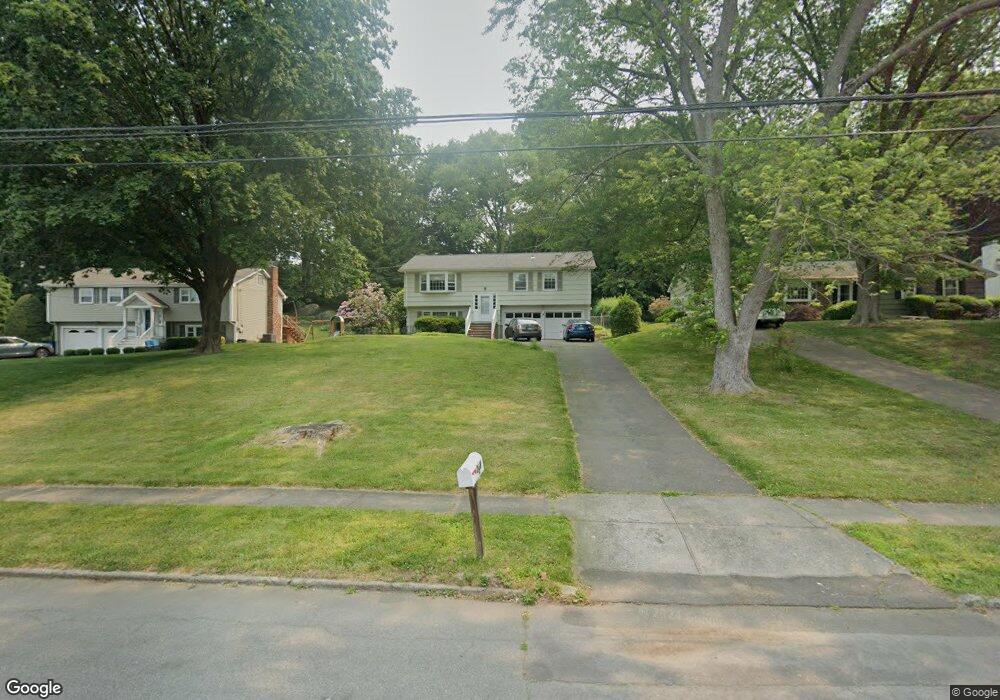
258 Carroll Rd Fairfield, CT 06824
University NeighborhoodEstimated Value: $739,000 - $915,308
3
Beds
3
Baths
1,312
Sq Ft
$621/Sq Ft
Est. Value
About This Home
This home is located at 258 Carroll Rd, Fairfield, CT 06824 and is currently estimated at $814,827, approximately $621 per square foot. 258 Carroll Rd is a home located in Fairfield County with nearby schools including Riverfield Elementary School, Roger Ludlowe Middle School, and Fairfield Ludlowe High School.
Ownership History
Date
Name
Owned For
Owner Type
Purchase Details
Closed on
Sep 30, 1998
Sold by
Daleski Edward J and Daleski Patricia J
Bought by
Bonney John and Bonney Elizabeth
Current Estimated Value
Purchase Details
Closed on
Nov 27, 1991
Sold by
Woods Stephen R and Woods Mary A
Bought by
Curt John and Bonney Elizabeth
Create a Home Valuation Report for This Property
The Home Valuation Report is an in-depth analysis detailing your home's value as well as a comparison with similar homes in the area
Home Values in the Area
Average Home Value in this Area
Purchase History
| Date | Buyer | Sale Price | Title Company |
|---|---|---|---|
| Bonney John | $292,000 | -- | |
| Bonney John | $292,000 | -- | |
| Curt John | $200,000 | -- |
Source: Public Records
Mortgage History
| Date | Status | Borrower | Loan Amount |
|---|---|---|---|
| Open | Curt John | $155,000 | |
| Closed | Curt John | $130,000 | |
| Closed | Curt John | $114,067 |
Source: Public Records
Tax History
| Year | Tax Paid | Tax Assessment Tax Assessment Total Assessment is a certain percentage of the fair market value that is determined by local assessors to be the total taxable value of land and additions on the property. | Land | Improvement |
|---|---|---|---|---|
| 2025 | $10,781 | $379,750 | $308,980 | $70,770 |
| 2024 | $10,595 | $379,750 | $308,980 | $70,770 |
| 2023 | $10,447 | $379,750 | $308,980 | $70,770 |
| 2022 | $10,344 | $379,750 | $308,980 | $70,770 |
| 2021 | $10,246 | $379,750 | $308,980 | $70,770 |
| 2020 | $10,355 | $386,540 | $305,830 | $80,710 |
| 2019 | $10,355 | $386,540 | $305,830 | $80,710 |
| 2018 | $10,189 | $386,540 | $305,830 | $80,710 |
| 2017 | $9,980 | $386,540 | $305,830 | $80,710 |
| 2016 | $9,837 | $386,540 | $305,830 | $80,710 |
| 2015 | $9,942 | $401,030 | $321,790 | $79,240 |
| 2014 | $9,785 | $401,030 | $321,790 | $79,240 |
Source: Public Records
Map
Nearby Homes
- 105 Charter Oak Rd
- 218 Lower Farm Rd
- 148 Millspaugh Dr
- 42 Robin Cir
- 360 Duck Farm Rd
- 1091 Round Hill Rd
- 196 Robin Ln
- 1353 Mill Plain Rd
- 359 Reid St
- 1478 Jennings Rd
- 68 Figlar Ave
- 245 Reid St
- 54 Ridgedale Rd
- 341 Crestwood Rd
- 115 Mayfair Rd
- 706 Judd St
- 15 Barton Rd
- 210 Pansy Rd
- 41 Pepperbush Ln
- 12 Sugar Plum Ln
- 240 Carroll Rd
- 251 Carroll Rd
- 290 Carroll Rd
- 233 Hanford Dr
- 269 Carroll Rd
- 237 Carroll Rd
- 224 Carroll Rd
- 35 Orchard Hill Ln
- 11 Orchard Hill Ln
- 215 Hanford Dr
- 55 Orchard Hill Ln
- 287 Carroll Rd
- 192 Carroll Rd
- 217 Carroll Rd
- 195 Carroll Rd
- 14 Orchard Hill Ln
- 315 Carroll Rd
- 38 Orchard Hill Ln
- 197 Hanford Dr
- 182 Hanford Dr
Your Personal Tour Guide
Ask me questions while you tour the home.