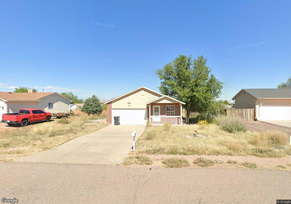
259 E Bond Dr Pueblo, CO 81007
Estimated Value: $285,087 - $295,000
3
Beds
2
Baths
1,038
Sq Ft
$281/Sq Ft
Est. Value
About This Home
This home is located at 259 E Bond Dr, Pueblo, CO 81007 and is currently estimated at $291,272, approximately $280 per square foot. 259 E Bond Dr is a home located in Pueblo County with nearby schools including Liberty Point Elementary School, Liberty Point International School, and Pueblo West High School.
Ownership History
Date
Name
Owned For
Owner Type
Purchase Details
Closed on
Sep 20, 2024
Sold by
Connors Catherine M
Bought by
Connors Daniel Patrick
Current Estimated Value
Purchase Details
Closed on
Nov 12, 2019
Sold by
Healey Kevin D
Bought by
Connors Catherine M
Purchase Details
Closed on
Sep 26, 2008
Sold by
Connors Catherine M
Bought by
Connors Catherine M and Healey Kevin D
Purchase Details
Closed on
Sep 7, 2007
Sold by
Dick Dana L
Bought by
Frimand Carolyn S
Home Financials for this Owner
Home Financials are based on the most recent Mortgage that was taken out on this home.
Original Mortgage
$104,995
Interest Rate
6.72%
Mortgage Type
FHA
Purchase Details
Closed on
Oct 25, 2001
Sold by
Dick Matthew A
Bought by
Dick Dana L
Purchase Details
Closed on
Jun 6, 2001
Sold by
Chapman Don
Bought by
Family Home + Building Corp
Purchase Details
Closed on
Jun 5, 2001
Sold by
Family Home + Building Corp
Bought by
Dick Matthew A
Purchase Details
Closed on
May 7, 2001
Sold by
Buchner Walter A + Theresa
Bought by
Chapman Don
Purchase Details
Closed on
Sep 15, 1997
Sold by
Masser Joanne M
Bought by
Buchner Walter A + Theresa
Purchase Details
Closed on
Jun 20, 1996
Sold by
Same
Bought by
Masser Joanne M
Purchase Details
Closed on
Jul 21, 1995
Bought by
Same
Purchase Details
Closed on
Mar 1, 1995
Sold by
Agler Darryl + Patricia
Bought by
Despres Karen and Despres Shirley Wentz
Purchase Details
Closed on
Nov 29, 1983
Sold by
Ferguson Donald R
Bought by
Agler Darryl + Patricia
Purchase Details
Closed on
Mar 31, 1980
Sold by
Ferguson Harold E + Adaline M
Bought by
Ferguson Donald R
Purchase Details
Closed on
Oct 28, 1970
Sold by
Lawyers Title
Bought by
Ferguson Harold E + Adaline M
Create a Home Valuation Report for This Property
The Home Valuation Report is an in-depth analysis detailing your home's value as well as a comparison with similar homes in the area
Home Values in the Area
Average Home Value in this Area
Purchase History
| Date | Buyer | Sale Price | Title Company |
|---|---|---|---|
| Connors Daniel Patrick | -- | None Listed On Document | |
| Connors Catherine M | -- | None Available | |
| Connors Catherine M | -- | Security Title | |
| Connors Catherine M | $119,900 | Security Title | |
| Frimand Carolyn S | $119,900 | Security Title | |
| Dick Dana L | -- | -- | |
| Family Home + Building Corp | $8,000 | -- | |
| Dick Matthew A | -- | -- | |
| Chapman Don | $6,200 | -- | |
| Buchner Walter A + Theresa | $7,000 | -- | |
| Masser Joanne M | $5,500 | -- | |
| Same | -- | -- | |
| Despres Karen | -- | -- | |
| Agler Darryl + Patricia | -- | -- | |
| Ferguson Donald R | -- | -- | |
| Ferguson Harold E + Adaline M | -- | -- | |
| Ferguson Harold E + Adaline M | -- | -- |
Source: Public Records
Mortgage History
| Date | Status | Borrower | Loan Amount |
|---|---|---|---|
| Previous Owner | Frimand Carolyn S | $104,995 |
Source: Public Records
Tax History
| Year | Tax Paid | Tax Assessment Tax Assessment Total Assessment is a certain percentage of the fair market value that is determined by local assessors to be the total taxable value of land and additions on the property. | Land | Improvement |
|---|---|---|---|---|
| 2024 | $1,360 | $13,530 | -- | -- |
| 2023 | $1,375 | $17,220 | $3,350 | $13,870 |
| 2022 | $1,233 | $12,285 | $2,090 | $10,195 |
| 2021 | $1,264 | $12,640 | $2,150 | $10,490 |
| 2020 | $987 | $12,640 | $2,150 | $10,490 |
| 2019 | $984 | $9,850 | $486 | $9,364 |
| 2018 | $856 | $8,562 | $490 | $8,072 |
| 2017 | $857 | $8,562 | $490 | $8,072 |
| 2016 | $814 | $8,143 | $716 | $7,427 |
| 2015 | $403 | $8,143 | $716 | $7,427 |
| 2014 | $371 | $7,484 | $796 | $6,688 |
Source: Public Records
Map
Nearby Homes
- 241 E Don Dr
- 662 S Bayfield Ave
- 243 E George Dr
- 649 S Bayfield Ave
- 642 S Bow Mar Dr
- 341 E Stanley Dr
- 311 E Stewart Dr
- 649 S Bond Dr E
- 602 S Del Rio Dr
- 77 E Dante Ln
- 601 S Inca Dr
- 659 S Camrose Dr
- 181 E Kipling Dr
- 576 S Falcon Dr
- 393 E Joe Martinez Blvd
- 279 E Kipling Dr
- 63 E Vern Dr
- 727 S Joe Martinez Ln
- 780 S Wolcott Dr
- 213 E Homer Dr
- 271 E Bond Dr
- 685 S Bayfield Ave
- 235 E Bond Dr
- 678 S Simla Dr
- 672 S Simla Dr
- 668 S Simla Dr
- 683 S Simla Dr
- 677 S Bayfield Ave
- 679 S Simla Dr
- 311 E Bond Dr
- 675 S Simla Dr
- 690 S Bayfield Ave
- 664 S Simla Dr Unit 4
- 664 S Simla Dr
- 686 S Bayfield Ave
- 671 S Simla Dr
- 207 E Bond Dr
- 207 E Bond Dr Unit 46
- 682 S Bayfield Ave
- 673 S Bayfield Ave
Your Personal Tour Guide
Ask me questions while you tour the home.