
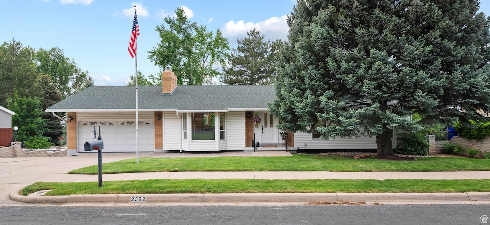
2592 S 50 W Bountiful, UT 84010
Estimated payment $4,143/month
Total Views
8,751
5
Beds
3
Baths
3,250
Sq Ft
$215
Price per Sq Ft
Highlights
- RV or Boat Parking
- ENERGY STAR Certified Homes
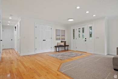
- Wood Flooring
- Boulton School Rated A-
- Rambler Architecture
- Main Floor Primary Bedroom
About This Home
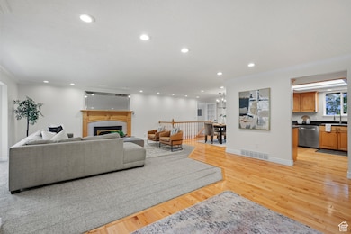
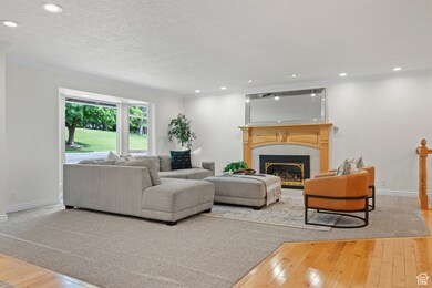
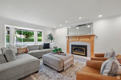
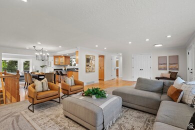
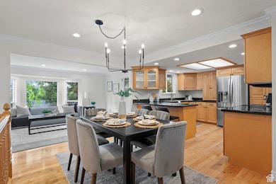
Welcome to your dream home in the picturesque setting of Bountiful, Utah! This beautifully remodeled 5-bedroom home with a huge workshop and RV garage. Step inside to discover a gorgeously renovated interior and newly added second living room on the upper floor, bathed in natural light streaming through expansive windows. This inviting space is perfect for relaxation or entertaining, offering ample room for friends and family. With the possibility of adding an ADU , this home provides incredible versatility to suit your lifestyle needs, from multi-generational living arrangements to generating rental income. This property seamlessly blends practical living with luxury and style, making it the perfect place to call home. Whether you're enjoying the modern touches of your own space or utilizing the abundant outdoor accommodations, this residence offers everything you need for comfortable living. The outdoor area features a large space perfect for RV parking, catering to adventurers and roadtrippers alike. If you have hobbies that require special space, look no further than the expansive gun shop or workshop, ideal for projects and storage. Don't miss the opportunity to own this unique, stunning home that provides both elegance and functionality. Schedule a visit today and make this your forever home! Buyer and Buyer's agent to verify all info.
Listing Agent
Alicia Schwartz
Coldwell Banker Realty (Union Heights) License #12127609 Listed on: 05/24/2025
Home Details
Home Type
- Single Family
Est. Annual Taxes
- $3,431
Year Built
- Built in 1974
Lot Details
- 9,583 Sq Ft Lot
- Landscaped
- Property is zoned Single-Family, R-4
Parking
- 2 Car Attached Garage
- 6 Carport Spaces
- RV or Boat Parking
Home Design
- Rambler Architecture
- Asphalt
Interior Spaces
- 3,250 Sq Ft Home
- 2-Story Property
- 3 Fireplaces
- Double Pane Windows
- Sliding Doors
- Granite Countertops
Flooring
- Wood
- Carpet
Bedrooms and Bathrooms
- 5 Bedrooms | 3 Main Level Bedrooms
- Primary Bedroom on Main
- 3 Full Bathrooms
Basement
- Walk-Out Basement
- Exterior Basement Entry
Schools
- Boulton Elementary School
- South Davis Middle School
- Woods Cross High School
Utilities
- Central Air
- Heating Available
Additional Features
- ENERGY STAR Certified Homes
- Balcony
Community Details
- No Home Owners Association
Listing and Financial Details
- Assessor Parcel Number 05-036-0008
Map
Create a Home Valuation Report for This Property
The Home Valuation Report is an in-depth analysis detailing your home's value as well as a comparison with similar homes in the area
Home Values in the Area
Average Home Value in this Area
Tax History
| Year | Tax Paid | Tax Assessment Tax Assessment Total Assessment is a certain percentage of the fair market value that is determined by local assessors to be the total taxable value of land and additions on the property. | Land | Improvement |
|---|---|---|---|---|
| 2024 | $3,432 | $323,400 | $120,006 | $203,394 |
| 2023 | $3,300 | $561,000 | $220,402 | $340,598 |
| 2022 | $3,241 | $307,450 | $120,249 | $187,201 |
| 2021 | $2,944 | $428,000 | $157,390 | $270,610 |
| 2020 | $2,598 | $379,000 | $134,191 | $244,809 |
| 2019 | $2,612 | $376,000 | $139,998 | $236,002 |
| 2018 | $2,453 | $348,000 | $137,192 | $210,808 |
| 2016 | $2,016 | $161,150 | $43,390 | $117,760 |
| 2015 | $1,920 | $145,090 | $43,390 | $101,700 |
| 2014 | $1,740 | $134,483 | $43,390 | $91,093 |
| 2013 | -- | $114,958 | $36,397 | $78,561 |
Source: Public Records
Property History
| Date | Event | Price | Change | Sq Ft Price |
|---|---|---|---|---|
| 06/27/2025 06/27/25 | For Sale | $698,500 | 0.0% | $215 / Sq Ft |
| 06/17/2025 06/17/25 | Pending | -- | -- | -- |
| 06/10/2025 06/10/25 | For Sale | $698,500 | 0.0% | $215 / Sq Ft |
| 06/06/2025 06/06/25 | Pending | -- | -- | -- |
| 05/24/2025 05/24/25 | For Sale | $698,500 | -- | $215 / Sq Ft |
Source: UtahRealEstate.com
Purchase History
| Date | Type | Sale Price | Title Company |
|---|---|---|---|
| Special Warranty Deed | -- | -- | |
| Interfamily Deed Transfer | -- | Salt Lake Title & Escrow Co | |
| Interfamily Deed Transfer | -- | Salt Lake Title & Escrow Co | |
| Interfamily Deed Transfer | -- | -- |
Source: Public Records
Mortgage History
| Date | Status | Loan Amount | Loan Type |
|---|---|---|---|
| Previous Owner | $109,301 | Commercial | |
| Previous Owner | $140,000 | Unknown | |
| Previous Owner | $141,501 | Unknown | |
| Previous Owner | $34,100 | Unknown | |
| Previous Owner | $37,800 | New Conventional |
Source: Public Records
Similar Homes in Bountiful, UT
Source: UtahRealEstate.com
MLS Number: 2087427
APN: 05-036-0008
Disclaimer: Certain information contained herein is derived from information provided by parties other than Homes.com. All information provided is deemed reliable, but is not guaranteed to be accurate and should be independently verified.
![]() IDX information is provided exclusively for consumers’ personal, non-commercial use, that it may not be used for any purpose other than to identify prospective properties consumers may be interested in purchasing, and that the data is deemed reliable but is not guaranteed accurate by the MLS. Licensor is only providing the MLS Content and not other sources of data provided in the Product.
IDX information is provided exclusively for consumers’ personal, non-commercial use, that it may not be used for any purpose other than to identify prospective properties consumers may be interested in purchasing, and that the data is deemed reliable but is not guaranteed accurate by the MLS. Licensor is only providing the MLS Content and not other sources of data provided in the Product.
Based on information from the Wasatch Front Regional Multiple Listing Service, Inc.. All data, including all measurements and calculations of area, is obtained from various sources and has not been, and will not be, verified by broker or the MLS. All information should be independently reviewed and verified for accuracy. Properties may or may not be listed by the office/agent presenting the information.
Nearby Homes
- 2858 S 50 W
- 2793 S Davis Blvd
- 117 W 3000 S
- 2717 S Orchard Dr
- 162 E 3000 S
- 2943 S 400 W
- 57 E 3300 S
- 3243 S 200 W
- 320 E 2100 S
- 468 W 2400 S
- 386 E 2100 S
- 3291 S 300 W
- 438 Indian Springs Rd
- 3463 S 50 E
- 1885 S 50 W
- 3049 S Orchard Dr Unit B
- 2095 S Main St Unit 21
- 2095 S Main St Unit 5
- 114 W 1900 S
- 141 W 3500 S
- 3042 S 200 E Unit 2
- 3069 S 300 W
- 386 E 2100 S
- 2520 S 500 W
- 2030 S Main St
- 644 E 1950 S
- 467 W 1875 South S
- 3371 Orchard Dr
- 850 N Highway 89
- 132 W 1500 S Unit CozyDown
- 1509 S Renaissance Towne Dr
- 453 W 1500 S
- 770 N Highway 89
- 2323 S 800 W
- 4 E 1100 S Unit Basement
- 678 Scenic Hills Dr Unit ID1249915P
- 517 S 100 E
- 4588 Spring Meadow Dr
- 335 S 200 E Unit 2
- 170 Odell Ln