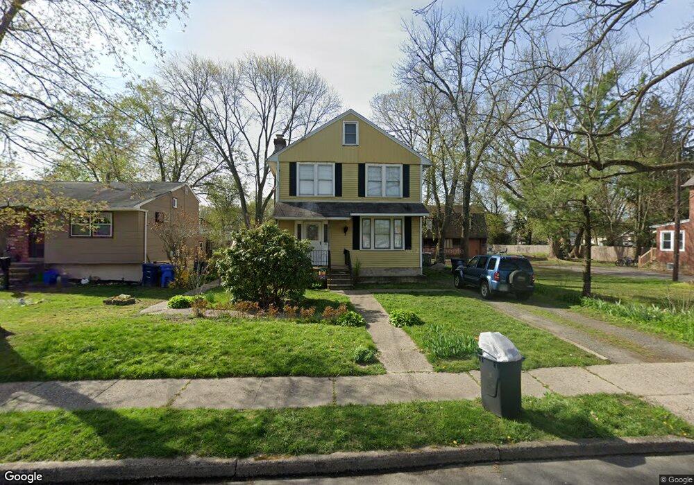
26 Anna Ave Maple Shade, NJ 08052
Estimated Value: $308,833 - $378,000
--
Bed
--
Bath
1,812
Sq Ft
$193/Sq Ft
Est. Value
About This Home
This home is located at 26 Anna Ave, Maple Shade, NJ 08052 and is currently estimated at $348,958, approximately $192 per square foot. 26 Anna Ave is a home located in Burlington County with nearby schools including Maude M. Wilkins Elementary School, Ralph J Steinhauer Elementary School, and Howard R Yocum School.
Ownership History
Date
Name
Owned For
Owner Type
Purchase Details
Closed on
Mar 19, 2001
Current Estimated Value
Purchase Details
Closed on
Sep 4, 1997
Sold by
Grande Kathleen M and Laskowski Adolph L
Bought by
Dugan Joseph M
Home Financials for this Owner
Home Financials are based on the most recent Mortgage that was taken out on this home.
Original Mortgage
$90,400
Interest Rate
7.31%
Purchase Details
Closed on
Dec 23, 1995
Sold by
Macdermott William and Cabaniss Dolores S
Bought by
Laskowski Adolph
Create a Home Valuation Report for This Property
The Home Valuation Report is an in-depth analysis detailing your home's value as well as a comparison with similar homes in the area
Home Values in the Area
Average Home Value in this Area
Purchase History
| Date | Buyer | Sale Price | Title Company |
|---|---|---|---|
| -- | -- | -- | |
| Dugan Joseph M | $113,000 | Credit Lenders Title Agency | |
| Laskowski Adolph | -- | -- |
Source: Public Records
Mortgage History
| Date | Status | Borrower | Loan Amount |
|---|---|---|---|
| Previous Owner | Dugan Joseph M | $90,400 |
Source: Public Records
Tax History Compared to Growth
Tax History
| Year | Tax Paid | Tax Assessment Tax Assessment Total Assessment is a certain percentage of the fair market value that is determined by local assessors to be the total taxable value of land and additions on the property. | Land | Improvement |
|---|---|---|---|---|
| 2025 | $7,167 | $188,800 | $50,900 | $137,900 |
| 2024 | $6,959 | $188,800 | $50,900 | $137,900 |
| 2023 | $6,959 | $188,800 | $50,900 | $137,900 |
| 2022 | $6,852 | $188,800 | $50,900 | $137,900 |
| 2021 | $6,454 | $188,800 | $50,900 | $137,900 |
| 2020 | $6,804 | $188,800 | $50,900 | $137,900 |
| 2019 | $6,555 | $188,800 | $50,900 | $137,900 |
| 2018 | $6,442 | $188,800 | $50,900 | $137,900 |
| 2017 | $6,366 | $188,800 | $50,900 | $137,900 |
| 2016 | $6,272 | $188,800 | $50,900 | $137,900 |
| 2015 | $6,136 | $188,800 | $50,900 | $137,900 |
| 2014 | $5,949 | $188,800 | $50,900 | $137,900 |
Source: Public Records
Map
Nearby Homes
- 107 S Forklanding Rd
- 57 S Terrace Ave
- 112 S Maple Ave
- 15 N Poplar Ave
- 22 Theodore Ave
- 410 S Forklanding Rd
- 48 N Terrace Ave
- 2 Gainor Ave
- 52 S Fellowship Rd
- 29 W Broadway
- 19 S Chestnut Ave
- 327 S Coles Ave
- 19 Farnsworth Ave
- 104 E Laurelton Ave
- 477 Buttonwood Ave
- 480 W Front St
- 301 N Coles Ave
- 44 S Pine Ave
- 5 Paul Rd
- 124 Stiles Ave