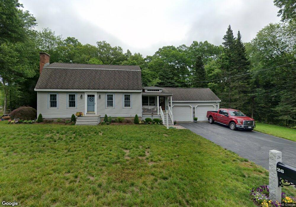
26 Braney Rd Millbury, MA 01527
Estimated Value: $606,000 - $717,000
3
Beds
2
Baths
2,160
Sq Ft
$301/Sq Ft
Est. Value
About This Home
This home is located at 26 Braney Rd, Millbury, MA 01527 and is currently estimated at $649,613, approximately $300 per square foot. 26 Braney Rd is a home located in Worcester County with nearby schools including Elmwood Street Elementary School, Raymond E. Shaw Elementary School, and Millbury Junior/Senior High School.
Ownership History
Date
Name
Owned For
Owner Type
Purchase Details
Closed on
Aug 17, 2007
Sold by
Susan A Harrington Ft and Harrington
Bought by
Donald and Donald Susan Harringto
Current Estimated Value
Purchase Details
Closed on
Aug 27, 2004
Sold by
Harrington Donald W
Bought by
Susan A Harrington Ft and Harrington
Create a Home Valuation Report for This Property
The Home Valuation Report is an in-depth analysis detailing your home's value as well as a comparison with similar homes in the area
Home Values in the Area
Average Home Value in this Area
Purchase History
| Date | Buyer | Sale Price | Title Company |
|---|---|---|---|
| Donald | -- | -- | |
| Donald | -- | -- | |
| Susan A Harrington Ft | -- | -- | |
| Susan A Harrington Ft | -- | -- |
Source: Public Records
Mortgage History
| Date | Status | Borrower | Loan Amount |
|---|---|---|---|
| Previous Owner | Susan A Harrington Ft | $160,000 |
Source: Public Records
Tax History Compared to Growth
Tax History
| Year | Tax Paid | Tax Assessment Tax Assessment Total Assessment is a certain percentage of the fair market value that is determined by local assessors to be the total taxable value of land and additions on the property. | Land | Improvement |
|---|---|---|---|---|
| 2025 | $7,466 | $557,600 | $124,600 | $433,000 |
| 2024 | $6,844 | $517,300 | $115,300 | $402,000 |
| 2023 | $6,218 | $430,300 | $80,700 | $349,600 |
| 2022 | $5,559 | $370,600 | $80,700 | $289,900 |
| 2021 | $5 | $355,200 | $80,700 | $274,500 |
| 2020 | $5,367 | $350,100 | $80,700 | $269,400 |
| 2019 | $5,340 | $336,900 | $80,400 | $256,500 |
| 2018 | $4,827 | $324,100 | $80,400 | $243,700 |
| 2017 | $5,005 | $304,600 | $83,900 | $220,700 |
| 2016 | $4,884 | $296,700 | $83,900 | $212,800 |
| 2015 | $4,805 | $291,900 | $89,400 | $202,500 |
| 2014 | $4,467 | $261,200 | $89,400 | $171,800 |
Source: Public Records
Map
Nearby Homes
- 20 Woodridge Rd
- 30 Lexington Rd
- 15 Rayburn Dr
- Lot 1 Cooper Rd
- 8 Autumn Gate Cir
- 123 Riverlin St
- 64 Millbury Ave
- 73 Potter Hill Rd
- 19 Cortland Way
- 19 Rice Rd
- 16 Jackie Dr
- 4 Thomas Hill Rd
- 90 Macarthur Dr
- 81 Ariel Cir
- 17 Atwood Ave
- 115 Ariel Cir
- 75 Potter Hill Rd
- 156 Brigham Hill Rd
- 5 Edward Dr
- 28 Lincoln Ln