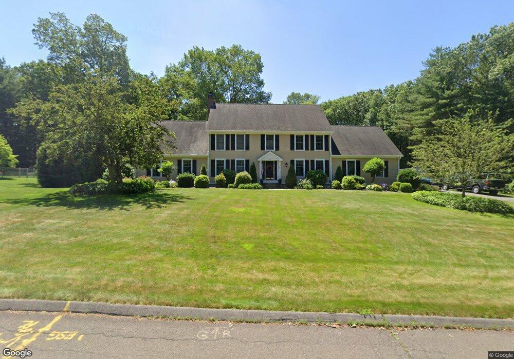
26 Briar Cliff Dr Wilbraham, MA 01095
Estimated Value: $778,891 - $871,000
4
Beds
4
Baths
3,588
Sq Ft
$231/Sq Ft
Est. Value
About This Home
This home is located at 26 Briar Cliff Dr, Wilbraham, MA 01095 and is currently estimated at $829,297, approximately $231 per square foot. 26 Briar Cliff Dr is a home located in Hampden County with nearby schools including Minnechaug Regional High School, Springfield International Charter School, and Wilbraham & Monson Academy.
Ownership History
Date
Name
Owned For
Owner Type
Purchase Details
Closed on
Sep 28, 2023
Sold by
Laliberte Brian and Laliberte Mary B
Bought by
Laliberte Ft and Laliberte
Current Estimated Value
Purchase Details
Closed on
Jul 13, 2001
Sold by
Zapolsky Valerie A
Bought by
Laliberte Brian and Laliberte Mary Beth
Create a Home Valuation Report for This Property
The Home Valuation Report is an in-depth analysis detailing your home's value as well as a comparison with similar homes in the area
Home Values in the Area
Average Home Value in this Area
Purchase History
| Date | Buyer | Sale Price | Title Company |
|---|---|---|---|
| Laliberte Ft | -- | None Available | |
| Laliberte Brian | $405,000 | -- |
Source: Public Records
Mortgage History
| Date | Status | Borrower | Loan Amount |
|---|---|---|---|
| Previous Owner | Laliberte Brian | $417,000 | |
| Previous Owner | Laliberte Brian | $45,000 |
Source: Public Records
Tax History Compared to Growth
Tax History
| Year | Tax Paid | Tax Assessment Tax Assessment Total Assessment is a certain percentage of the fair market value that is determined by local assessors to be the total taxable value of land and additions on the property. | Land | Improvement |
|---|---|---|---|---|
| 2025 | $13,244 | $740,700 | $137,300 | $603,400 |
| 2024 | $13,122 | $709,300 | $137,300 | $572,000 |
| 2023 | $12,037 | $643,700 | $137,300 | $506,400 |
| 2022 | $11,798 | $575,800 | $137,300 | $438,500 |
| 2021 | $11,776 | $512,900 | $143,200 | $369,700 |
| 2020 | $11,479 | $512,900 | $143,200 | $369,700 |
| 2019 | $11,183 | $513,000 | $143,200 | $369,800 |
| 2018 | $11,137 | $491,900 | $143,200 | $348,700 |
| 2017 | $10,822 | $491,900 | $143,200 | $348,700 |
| 2016 | $10,519 | $487,000 | $148,000 | $339,000 |
| 2015 | $10,169 | $487,000 | $148,000 | $339,000 |
Source: Public Records
Map
Nearby Homes
- 11 Wellfleet Dr
- 34 Blacksmith Rd
- 15 Sandalwood Dr Unit site 00
- 6V Melikian Dr
- 26 Sandalwood Dr
- 111 Sandalwood Dr Unit site 00
- 103 Sandalwood Dr Unit site 00
- 136 Joan St
- 57 Sandalwood Dr Unit site 61
- 99 Sandalwood Dr Unit site 00
- 211 Glenoak Dr
- 500 Springfield St
- 6 Teak Terrace Unit 24
- 10 Forest Glade Dr
- 41 Queensbury Dr
- 24 Lodge Ln Unit 24
- 116 Cherry Dr Unit 116
- 135 Bulat Dr
- 40 Peekskill Ave
- 2306 Wilbraham Rd
- 24 Briar Cliff Dr
- 28 Briar Cliff Dr
- 0 Briar Cliff Dr
- 27 Briar Cliff Dr
- 29 Briar Cliff Dr
- 22 Briar Cliff Dr
- 18 Bellows Rd
- 25 Briar Cliff Dr
- 20 Tracy Dr
- 16 Bellows Rd
- 14 Bellows Rd
- 20 Briar Cliff Dr
- 17 Bellows Rd
- 12 Bellows Rd
- 21 Briar Cliff Dr
- 15 Bellows Rd
- 18 Briar Cliff Dr
- 10 Bellows Rd
- 3 Harness Dr
- 9 Horseshoe Ln