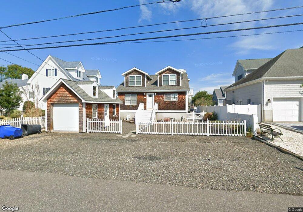
26 Cove Rd Toms River, NJ 08753
Estimated Value: $716,336 - $1,066,000
4
Beds
2
Baths
1,990
Sq Ft
$440/Sq Ft
Est. Value
About This Home
This home is located at 26 Cove Rd, Toms River, NJ 08753 and is currently estimated at $875,584, approximately $439 per square foot. 26 Cove Rd is a home located in Ocean County with nearby schools including St Joseph Grade School and Donovan Catholic High School.
Ownership History
Date
Name
Owned For
Owner Type
Purchase Details
Closed on
Apr 29, 2008
Sold by
Bloodgood Mark and Bloodgood Victoria
Bought by
Lagatutta Dolores
Current Estimated Value
Purchase Details
Closed on
Sep 7, 2006
Sold by
Bloodgood Robert and Bloodgood Betty Lou
Bought by
Bloodgood Mark and Bloodgood Victoria
Home Financials for this Owner
Home Financials are based on the most recent Mortgage that was taken out on this home.
Original Mortgage
$420,000
Interest Rate
6.12%
Mortgage Type
Purchase Money Mortgage
Purchase Details
Closed on
Apr 10, 1996
Sold by
Betz Charles
Bought by
Bloodgood Mark and Bloodgood Victoria
Home Financials for this Owner
Home Financials are based on the most recent Mortgage that was taken out on this home.
Original Mortgage
$96,000
Interest Rate
7.39%
Create a Home Valuation Report for This Property
The Home Valuation Report is an in-depth analysis detailing your home's value as well as a comparison with similar homes in the area
Home Values in the Area
Average Home Value in this Area
Purchase History
| Date | Buyer | Sale Price | Title Company |
|---|---|---|---|
| Lagatutta Dolores | $630,000 | Stewart Title Guaranty | |
| Bloodgood Mark | -- | None Available | |
| Bloodgood Mark | $119,900 | -- |
Source: Public Records
Mortgage History
| Date | Status | Borrower | Loan Amount |
|---|---|---|---|
| Previous Owner | Bloodgood Mark | $420,000 | |
| Previous Owner | Bloodgood Mark | $96,000 |
Source: Public Records
Tax History Compared to Growth
Tax History
| Year | Tax Paid | Tax Assessment Tax Assessment Total Assessment is a certain percentage of the fair market value that is determined by local assessors to be the total taxable value of land and additions on the property. | Land | Improvement |
|---|---|---|---|---|
| 2025 | $9,741 | $534,900 | $235,000 | $299,900 |
| 2024 | $9,259 | $534,900 | $235,000 | $299,900 |
| 2023 | $8,927 | $534,900 | $235,000 | $299,900 |
| 2022 | $8,927 | $534,900 | $235,000 | $299,900 |
| 2021 | $8,769 | $350,200 | $153,900 | $196,300 |
| 2020 | $8,734 | $350,200 | $153,900 | $196,300 |
| 2019 | $8,356 | $350,200 | $153,900 | $196,300 |
| 2018 | $8,244 | $350,200 | $153,900 | $196,300 |
| 2017 | $8,174 | $350,200 | $153,900 | $196,300 |
| 2016 | $7,960 | $350,200 | $153,900 | $196,300 |
| 2015 | $8,186 | $374,300 | $153,900 | $220,400 |
| 2014 | $7,793 | $374,300 | $153,900 | $220,400 |
Source: Public Records
Map
Nearby Homes
- 6 Cayman Ave
- 103 Mermaid Rd
- 4 Jamaica Ave
- 3312 Churchill Dr
- 3414 Sandy Place
- 3158 Windsor Ave
- 689 Golden Dr
- 663 Beachwood Ave
- 3131 Creek Rd
- 3138 Windsor Ave
- 3129 Windsor Ave
- 2570 Balfrey Dr
- 213 Hamilton Dr
- 786 Garfield Ave
- 3402 Maritime Dr
- 1221 Bewick St
- 562 George Rd
- 3461 Maritime Dr
- 1417 Delaware Ave
- 3414 Adams Ave