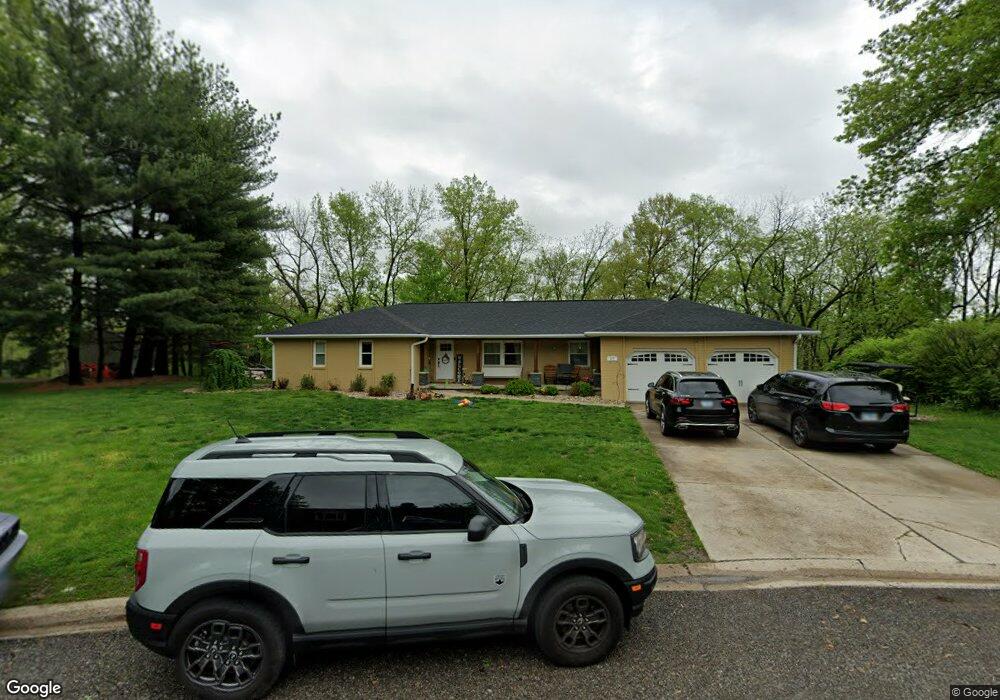
26 Covered Bridge Acres Unit 1 Glenarm, IL 62536
Estimated Value: $283,000 - $319,103
--
Bed
--
Bath
--
Sq Ft
1.09
Acres
About This Home
This home is located at 26 Covered Bridge Acres Unit 1, Glenarm, IL 62536 and is currently estimated at $303,776. 26 Covered Bridge Acres Unit 1 is a home located in Sangamon County with nearby schools including Ball Elementary School, Glenwood Middle School, and Glenwood Intermediate School.
Ownership History
Date
Name
Owned For
Owner Type
Purchase Details
Closed on
Jan 18, 2019
Sold by
Badman Joshua L and Badman Jenifer L
Bought by
Smith Peter J and Smith Nicole
Current Estimated Value
Home Financials for this Owner
Home Financials are based on the most recent Mortgage that was taken out on this home.
Original Mortgage
$265,109
Outstanding Balance
$234,391
Interest Rate
4.88%
Mortgage Type
FHA
Estimated Equity
$69,385
Purchase Details
Closed on
Oct 4, 2012
Purchase Details
Closed on
Jun 29, 2012
Purchase Details
Closed on
Nov 4, 2011
Purchase Details
Closed on
Oct 28, 2003
Purchase Details
Closed on
Apr 24, 2000
Create a Home Valuation Report for This Property
The Home Valuation Report is an in-depth analysis detailing your home's value as well as a comparison with similar homes in the area
Home Values in the Area
Average Home Value in this Area
Purchase History
| Date | Buyer | Sale Price | Title Company |
|---|---|---|---|
| Smith Peter J | $270,000 | Illinois Real Estate Title | |
| -- | $125,000 | -- | |
| -- | -- | -- | |
| -- | -- | -- | |
| -- | -- | -- | |
| -- | $168,500 | -- |
Source: Public Records
Mortgage History
| Date | Status | Borrower | Loan Amount |
|---|---|---|---|
| Open | Smith Peter J | $265,109 |
Source: Public Records
Tax History Compared to Growth
Tax History
| Year | Tax Paid | Tax Assessment Tax Assessment Total Assessment is a certain percentage of the fair market value that is determined by local assessors to be the total taxable value of land and additions on the property. | Land | Improvement |
|---|---|---|---|---|
| 2024 | $6,105 | $92,740 | $9,014 | $83,726 |
| 2023 | $5,794 | $84,042 | $8,169 | $75,873 |
| 2022 | $5,522 | $78,397 | $7,620 | $70,777 |
| 2021 | $5,293 | $74,451 | $7,236 | $67,215 |
| 2020 | $5,179 | $73,041 | $7,099 | $65,942 |
| 2019 | $4,992 | $71,665 | $6,965 | $64,700 |
| 2018 | $4,488 | $71,686 | $6,967 | $64,719 |
| 2017 | $4,443 | $71,686 | $6,967 | $64,719 |
| 2016 | $4,380 | $70,900 | $6,891 | $64,009 |
| 2015 | $4,298 | $68,809 | $6,688 | $62,121 |
| 2014 | $4,174 | $66,662 | $6,479 | $60,183 |
| 2013 | $4,023 | $64,689 | $6,287 | $58,402 |
Source: Public Records
Map
Nearby Homes
- 2214 Hopwood Dr
- 404 Sundown Ln
- 10553 S Main St Unit 1
- 203 Huntington Rd
- 248 Prairie Grass Rd
- 337 Keystone Dr
- 108 Kodiak Dr
- 327 Aspen Dr
- 1600 E Spruce St
- 315 Aspen Dr
- 121 Ramblewood Rd
- 104 Northwoods Ct
- 318 Ramblewood Rd
- 400 Ramblewood Rd
- 405 Ramblewood Rd
- 401 Ramblewood Rd
- 448 Wintergreen Dr
- 911 Mesa Dr
- 802 E Locust St
- 309 Dewberry Trail
- 15 Covered Bridge Acres Unit 1
- 27 Covered Brdige Acres
- 27 Covered Bridge Acres Unit 1
- 25 Covered Bridge Acres Unit 1
- 14 Covered Bridge Acres Unit 1
- 28 Covered Bridge Acres Unit 1
- 16 Covered Bridge Acres Unit 1
- 24 Covered Bridge Acres
- 13 Covered Bridge Acres Unit 1
- 29 Covered Bridge Acres Unit 1
- 23 Covered Bridge Acres
- 17 Covered Bridge Acres Unit 1
- 30 Covered Bridge Acres Unit 1
- 22 Covered Bridge Acres Unit 1
- 12 Covered Bridge Acres Unit 1
- 31 Covered Bridge Acres Unit 1
- 21 Covered Bridge Acres Unit 1
- 21 Covered Bridge Acres
- 18 Covered Bridge Acres Unit 1
- 10 Covered Bridge Acres Unit 1