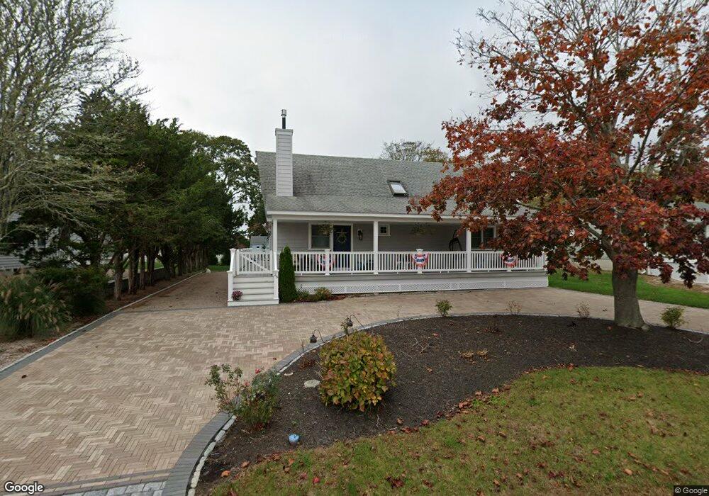
26 Kimball Ave Westerly, RI 02891
Estimated Value: $978,000 - $1,262,000
3
Beds
2
Baths
1,667
Sq Ft
$696/Sq Ft
Est. Value
About This Home
This home is located at 26 Kimball Ave, Westerly, RI 02891 and is currently estimated at $1,160,509, approximately $696 per square foot. 26 Kimball Ave is a home located in Washington County with nearby schools including Westerly High School and St. Michael School.
Ownership History
Date
Name
Owned For
Owner Type
Purchase Details
Closed on
Apr 19, 2013
Sold by
Zoccoli Karen M
Bought by
Karen M Zoccoli Ret and Zoccoli
Current Estimated Value
Purchase Details
Closed on
Dec 21, 2012
Sold by
Fredrick M D
Bought by
Zoccoli Karen M and Zoccoli Nicholas J
Home Financials for this Owner
Home Financials are based on the most recent Mortgage that was taken out on this home.
Original Mortgage
$349,600
Interest Rate
2.73%
Mortgage Type
New Conventional
Create a Home Valuation Report for This Property
The Home Valuation Report is an in-depth analysis detailing your home's value as well as a comparison with similar homes in the area
Home Values in the Area
Average Home Value in this Area
Purchase History
| Date | Buyer | Sale Price | Title Company |
|---|---|---|---|
| Karen M Zoccoli Ret | -- | -- | |
| Zoccoli Karen M | -- | -- | |
| Zoccoli Karen M | $437,000 | -- |
Source: Public Records
Mortgage History
| Date | Status | Borrower | Loan Amount |
|---|---|---|---|
| Previous Owner | Zoccoli Karen M | $349,600 | |
| Previous Owner | Zoccoli Karen M | $200,000 |
Source: Public Records
Tax History
| Year | Tax Paid | Tax Assessment Tax Assessment Total Assessment is a certain percentage of the fair market value that is determined by local assessors to be the total taxable value of land and additions on the property. | Land | Improvement |
|---|---|---|---|---|
| 2025 | $8,150 | $1,146,300 | $616,600 | $529,700 |
| 2024 | $8,625 | $879,200 | $440,700 | $438,500 |
| 2023 | $8,458 | $879,200 | $440,700 | $438,500 |
| 2022 | $8,405 | $879,200 | $440,700 | $438,500 |
| 2021 | $7,639 | $663,100 | $319,600 | $343,500 |
| 2020 | $7,500 | $663,100 | $319,600 | $343,500 |
| 2019 | $7,427 | $663,100 | $319,600 | $343,500 |
| 2018 | $7,448 | $626,900 | $290,500 | $336,400 |
| 2017 | $6,040 | $521,100 | $290,500 | $230,600 |
| 2016 | $6,086 | $521,100 | $290,500 | $230,600 |
| 2015 | $5,753 | $531,700 | $296,500 | $235,200 |
| 2014 | $5,657 | $531,700 | $296,500 | $235,200 |
Source: Public Records
Map
Nearby Homes
- 27 Benson Ave
- 10 Tristam St
- 9 Compass Way Unit 201
- 9 Compass Way Unit 202
- 9 Compass Way Unit 101
- 9 Compass Way Unit 102
- 9 Compass Way Unit 103
- 9 Compass Way Unit 203
- 4 Shore Rd
- 109 Watch Hill Rd
- 4 Quail Run
- 20 Browning Rd
- 52 Avondale Rd
- 60 Avondale Rd
- 417 River Rd
- 9 Champlin Dr
- 432 Atlantic Ave
- 18 Timothy Dr
- 446 Atlantic Ave
- 19 Wicklow Rd
- 28 Kimball Ave
- 24 Kimball Ave
- 25 Kimball Ave
- 30 Kimball Ave
- 22 Kimball Ave
- 30 Fishermans Ave
- 31 Kimball Ave
- 34 Fishermans Ave
- 32 Kimball Ave
- 39 Benson Ave
- 36 Fishermans Ave
- 43 Benson Ave
- 33 Benson Ave
- 28 Fishermans Ave
- 20 Kimball Ave
- 34 Kimball Ave
- 45 Benson Ave
- 38 Fishermans Ave
- 31 Benson Ave
- 33 Kimball Ave
Your Personal Tour Guide
Ask me questions while you tour the home.