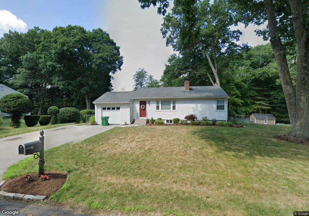
26 Laurelton Dr Ashland, MA 01721
Estimated Value: $521,000 - $579,089
2
Beds
1
Bath
1,288
Sq Ft
$425/Sq Ft
Est. Value
About This Home
This home is located at 26 Laurelton Dr, Ashland, MA 01721 and is currently estimated at $548,022, approximately $425 per square foot. 26 Laurelton Dr is a home located in Middlesex County with nearby schools including William Pittaway Elementary School, David Mindess Elementary School, and Henry E. Warren Elementary School.
Ownership History
Date
Name
Owned For
Owner Type
Purchase Details
Closed on
Nov 18, 2011
Sold by
Constitution Props Llc
Bought by
Gentilucci Elise M and Gentilucci Ivano
Current Estimated Value
Home Financials for this Owner
Home Financials are based on the most recent Mortgage that was taken out on this home.
Original Mortgage
$244,218
Outstanding Balance
$165,727
Interest Rate
3.92%
Mortgage Type
Purchase Money Mortgage
Estimated Equity
$382,295
Purchase Details
Closed on
Jun 24, 2011
Sold by
Prefontaine Philip N
Bought by
Constitution Props Llc
Create a Home Valuation Report for This Property
The Home Valuation Report is an in-depth analysis detailing your home's value as well as a comparison with similar homes in the area
Home Values in the Area
Average Home Value in this Area
Purchase History
| Date | Buyer | Sale Price | Title Company |
|---|---|---|---|
| Gentilucci Elise M | $260,000 | -- | |
| Constitution Props Llc | $99,250 | -- |
Source: Public Records
Mortgage History
| Date | Status | Borrower | Loan Amount |
|---|---|---|---|
| Open | Gentilucci Elise M | $244,218 |
Source: Public Records
Tax History Compared to Growth
Tax History
| Year | Tax Paid | Tax Assessment Tax Assessment Total Assessment is a certain percentage of the fair market value that is determined by local assessors to be the total taxable value of land and additions on the property. | Land | Improvement |
|---|---|---|---|---|
| 2025 | $6,303 | $493,600 | $246,100 | $247,500 |
| 2024 | $6,165 | $465,600 | $246,100 | $219,500 |
| 2023 | $5,727 | $415,900 | $234,400 | $181,500 |
| 2022 | $5,907 | $372,000 | $213,100 | $158,900 |
| 2021 | $10,098 | $347,300 | $213,100 | $134,200 |
| 2020 | $5,326 | $329,600 | $216,300 | $113,300 |
| 2019 | $5,175 | $317,900 | $216,300 | $101,600 |
| 2018 | $4,048 | $309,100 | $214,300 | $94,800 |
| 2017 | $5,043 | $302,000 | $214,300 | $87,700 |
| 2016 | $4,886 | $287,400 | $211,500 | $75,900 |
| 2015 | $4,643 | $268,400 | $199,300 | $69,100 |
| 2014 | $4,462 | $256,600 | $176,800 | $79,800 |
Source: Public Records
Map
Nearby Homes
- 56 Woodland Rd
- 101 Olive St
- 10 Clinton St
- 28-30 Olive St
- 9 Olive St
- 43 Haven Way
- 65 Braeburn Ln Unit 65
- 2 Curtis Rd
- 20 Braeburn Ln
- 12 Braeburn Ln
- 0 Cross St
- 11 Voyagers Ln
- 31 Cherry Ln Unit 31
- 4 Waterville Ln Unit 4
- 13 Clark St
- 10 Waterville Ln Unit 10
- 12 Waterville Ln Unit 12
- 6 New Castle Rd
- 638 Main St
- 203 Pleasant St
- 30 Laurelton Dr
- 22 Laurelton Dr
- 27 Laurelton Dr
- 34 Laurelton Dr
- 23 Laurelton Dr
- 50 Woodland Rd
- 31 Laurelton Dr
- 19 Laurelton Dr
- 44 Woodland Rd
- 62 Woodland Rd
- 38 Laurelton Dr
- 15 Laurelton Dr
- 37 Laurelton Dr
- 7 Cary Dr L7 Towne Line
- 10 Laurelton Dr
- 9 Laurelton Dr
- 49 Woodland Rd
- 55 Woodland Rd
- 68 Woodland Rd
- 45 Woodland Rd