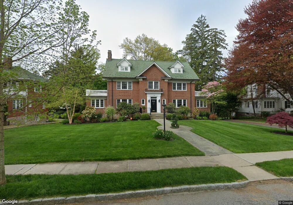
26 Longvue Ave New Rochelle, NY 10804
Paine Heights NeighborhoodEstimated Value: $1,669,839 - $2,631,000
6
Beds
5
Baths
3,914
Sq Ft
$498/Sq Ft
Est. Value
About This Home
This home is located at 26 Longvue Ave, New Rochelle, NY 10804 and is currently estimated at $1,950,960, approximately $498 per square foot. 26 Longvue Ave is a home located in Westchester County with nearby schools including William B. Ward Elementary School, Albert Leonard Middle School, and New Rochelle High School.
Ownership History
Date
Name
Owned For
Owner Type
Purchase Details
Closed on
Aug 12, 2004
Sold by
Major Steven and Major Aliza
Bought by
Regan Michael
Current Estimated Value
Home Financials for this Owner
Home Financials are based on the most recent Mortgage that was taken out on this home.
Original Mortgage
$500,000
Interest Rate
6.02%
Mortgage Type
Purchase Money Mortgage
Purchase Details
Closed on
Apr 9, 2002
Sold by
Levine Marshall E
Bought by
Major Steven and Major Aliza
Home Financials for this Owner
Home Financials are based on the most recent Mortgage that was taken out on this home.
Original Mortgage
$573,750
Interest Rate
6.8%
Mortgage Type
Purchase Money Mortgage
Create a Home Valuation Report for This Property
The Home Valuation Report is an in-depth analysis detailing your home's value as well as a comparison with similar homes in the area
Home Values in the Area
Average Home Value in this Area
Purchase History
| Date | Buyer | Sale Price | Title Company |
|---|---|---|---|
| Regan Michael | $1,607,000 | Stewart Title Insurance Co | |
| Major Steven | $765,000 | Chicago Title Insurance Co |
Source: Public Records
Mortgage History
| Date | Status | Borrower | Loan Amount |
|---|---|---|---|
| Previous Owner | Regan Michael | $500,000 | |
| Previous Owner | Major Steven | $573,750 |
Source: Public Records
Tax History Compared to Growth
Tax History
| Year | Tax Paid | Tax Assessment Tax Assessment Total Assessment is a certain percentage of the fair market value that is determined by local assessors to be the total taxable value of land and additions on the property. | Land | Improvement |
|---|---|---|---|---|
| 2024 | $31,680 | $23,200 | $6,900 | $16,300 |
| 2023 | $27,887 | $23,200 | $6,900 | $16,300 |
| 2022 | $30,183 | $23,200 | $6,900 | $16,300 |
| 2021 | $30,076 | $23,200 | $6,900 | $16,300 |
| 2020 | $25,005 | $23,200 | $6,900 | $16,300 |
| 2019 | $28,959 | $23,200 | $6,900 | $16,300 |
| 2018 | $24,338 | $23,200 | $6,900 | $16,300 |
| 2017 | $18,019 | $23,200 | $6,900 | $16,300 |
| 2016 | $26,849 | $23,200 | $6,900 | $16,300 |
| 2015 | $22,742 | $23,200 | $6,900 | $16,300 |
| 2014 | $22,742 | $23,200 | $6,900 | $16,300 |
| 2013 | $22,742 | $23,200 | $6,900 | $16,300 |
Source: Public Records
Map
Nearby Homes
- 175 Lyncroft Rd
- 120 Lyncroft Rd
- 50 Forest Cir
- 290 Overlook Rd
- 220 Pinebrook Blvd
- 7 Crestwood Ln
- 5 Antler Place
- 150 Maywood Rd
- 2 Byworth Rd
- 49 Overlook Cir
- 114 Oxford Rd
- 54 Broadview Ave
- 25 Woodhollow Ln
- 240 Beechmont Dr
- 43 Broadview Ave
- 60 Aberfoyle Rd
- 43 Pinebrook Rd
- 117 Perth Ave
- 67 Bon Air Ave
- 130 Woodhollow Ln