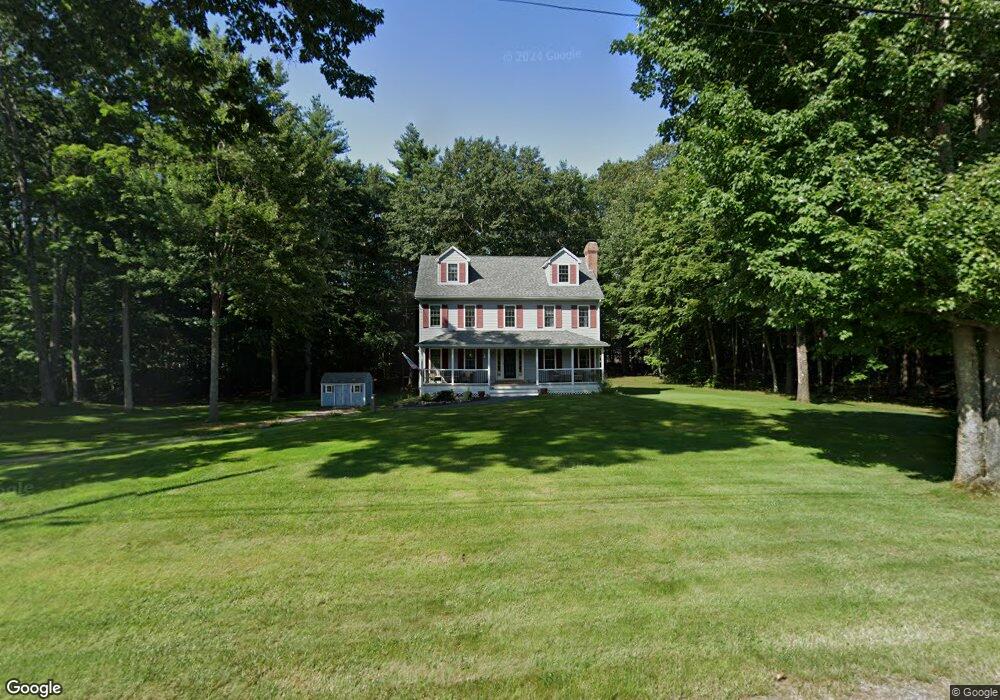
26 Lynette Ln Fremont, NH 03044
Estimated Value: $590,000 - $636,685
3
Beds
3
Baths
2,059
Sq Ft
$301/Sq Ft
Est. Value
About This Home
This home is located at 26 Lynette Ln, Fremont, NH 03044 and is currently estimated at $619,421, approximately $300 per square foot. 26 Lynette Ln is a home located in Rockingham County with nearby schools including Ellis School.
Ownership History
Date
Name
Owned For
Owner Type
Purchase Details
Closed on
Nov 20, 2023
Sold by
Hult Scott E and Hult Jean M
Bought by
S And J Hult Ft and Hult
Current Estimated Value
Purchase Details
Closed on
Oct 14, 1999
Sold by
Dambrosia Raymond and Dambrosia Julie M
Bought by
Hult Scott E and Hult Jean H
Home Financials for this Owner
Home Financials are based on the most recent Mortgage that was taken out on this home.
Original Mortgage
$145,000
Interest Rate
7.8%
Mortgage Type
Purchase Money Mortgage
Create a Home Valuation Report for This Property
The Home Valuation Report is an in-depth analysis detailing your home's value as well as a comparison with similar homes in the area
Home Values in the Area
Average Home Value in this Area
Purchase History
| Date | Buyer | Sale Price | Title Company |
|---|---|---|---|
| S And J Hult Ft | -- | None Available | |
| Hult Scott E | $200,000 | -- |
Source: Public Records
Mortgage History
| Date | Status | Borrower | Loan Amount |
|---|---|---|---|
| Previous Owner | Hult Scott E | $200,000 | |
| Previous Owner | Hult Scott E | $224,000 | |
| Previous Owner | Hult Scott E | $90,000 | |
| Previous Owner | Hult Scott E | $145,000 |
Source: Public Records
Tax History Compared to Growth
Tax History
| Year | Tax Paid | Tax Assessment Tax Assessment Total Assessment is a certain percentage of the fair market value that is determined by local assessors to be the total taxable value of land and additions on the property. | Land | Improvement |
|---|---|---|---|---|
| 2024 | $8,834 | $335,000 | $120,300 | $214,700 |
| 2023 | $7,903 | $335,000 | $120,300 | $214,700 |
| 2022 | $7,769 | $335,000 | $120,300 | $214,700 |
| 2021 | $7,491 | $335,600 | $120,300 | $215,300 |
| 2020 | $7,762 | $335,600 | $120,300 | $215,300 |
| 2019 | $7,890 | $254,100 | $89,700 | $164,400 |
| 2018 | $8,645 | $254,100 | $89,700 | $164,400 |
| 2017 | $7,417 | $254,100 | $89,700 | $164,400 |
| 2016 | $7,807 | $254,600 | $89,700 | $164,900 |
| 2015 | $7,383 | $254,600 | $89,700 | $164,900 |
| 2014 | $7,312 | $259,100 | $85,500 | $173,600 |
| 2013 | $7,387 | $259,100 | $85,500 | $173,600 |
Source: Public Records
Map
Nearby Homes
- 28 Leavitt Rd
- 38 Bluefish Dr
- 1 Annika Lee Dr Unit B
- 266 Route 125
- 62 Lyford Ln
- 454 Main St
- 164 Hall Rd
- 40 Depot Rd
- 564 Main St
- 308 Main St
- 98 Copp Dr
- The Laurel Plan at Pleasant View Farm
- The Ridgemont Plan at Pleasant View Farm
- The Leyland Plan at Pleasant View Farm
- The Rosewood Plan at Pleasant View Farm
- 11 Walker Rd Unit 11B
- 3 Walker Rd Unit 3A
- 240 Main St
- 188 Main St
- 32 Country Ln
- 145 Gristmill Rd
- 38 Lynette Ln
- 16 Lynette Ln
- 33 Lynette Ln
- 92 Lynette Ln
- 2-1 Risloves Way
- 2-1 Risloves Way
- 2-1 Risloves Way Unit 2
- 55 Lynette Ln
- 62 Tavern Rd
- 3 Lynette Ln
- 18 Risloves Way
- 24 Risloves Way
- 14 Risloves Way Unit 14-1
- 14 Risloves Way Unit 2
- 14 Risloves Way Unit 1
- 14 Risloves Way Unit 1 (B)
- 50 Lynette Ln
- 76 Lynette Ln
- 1-2 Risloves Way