
Seller's Agent in 2025
Melissa Kiehl
KW Legacy Partners
(860) 480-4169
1 in this area
114 Total Sales
Estimated Value: $295,000 - $347,101
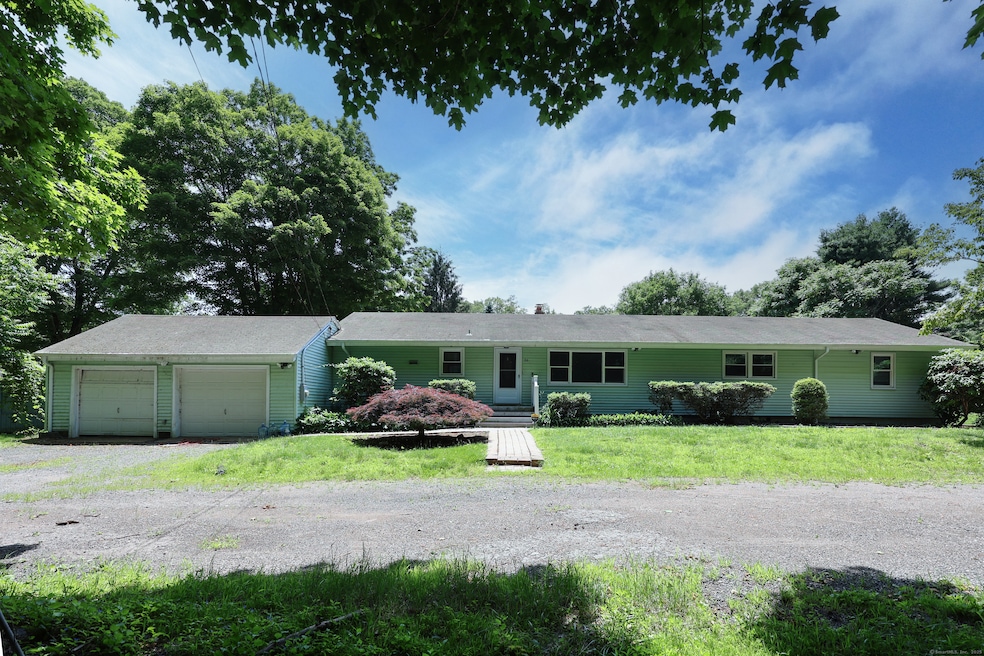
Introducing 26 Paula Road, an inviting home nestled in the picturesque town of East Haddam! This well-maintained ranch property offers the perfect blend of peaceful countryside living and modern comfort, with easy access to all the amenities you need. The interior of this home is designed with an open concept in mind. The large, bright living room boasts beautiful hardwood floors and flows seamlessly into the dining area, with natural light pouring through the windows, perfect for entertaining or family gatherings. The kitchen is fully equipped with granite counters, modern appliances, ample counter space, and plenty of cabinetry for storage. Four spacious bedrooms are perfect for family, guests, or a home office. The lower level offers additional possibilities for a home gym or recreation area which opens up a variety of possibilities for your lifestyle needs. Outside, the expansive backyard offers plenty of room for outdoor activities or gardening. The property also features an attached 2-car garage, providing convenient storage and parking. A whole house generator. Don't miss the opportunity to make this lovely house your next home. Schedule your private showing today!
Last Agent to Sell the Property
KW Legacy Partners License #RES.0802690 Listed on: 06/06/2025
| Date | Buyer | Sale Price | Title Company |
|---|---|---|---|
| Locke David G | $329,000 | -- | |
| Key Human Svcs Inc | -- | -- | |
| Key Human Svcs Inc | -- | -- | |
| Cil Realty Inc | $270,000 | -- | |
| Cil Realty Inc | $270,000 | -- |
| Date | Status | Borrower | Loan Amount |
|---|---|---|---|
| Previous Owner | Cil Realty Inc | $424,993 | |
| Previous Owner | Cil Realty Inc | $25,000 |
| Date | Event | Price | List to Sale | Price per Sq Ft |
|---|---|---|---|---|
| 07/29/2025 07/29/25 | Sold | $329,000 | -5.7% | $166 / Sq Ft |
| 07/12/2025 07/12/25 | Pending | -- | -- | -- |
| 06/06/2025 06/06/25 | For Sale | $349,000 | -- | $176 / Sq Ft |
| Year | Tax Paid | Tax Assessment Tax Assessment Total Assessment is a certain percentage of the fair market value that is determined by local assessors to be the total taxable value of land and additions on the property. | Land | Improvement |
|---|---|---|---|---|
| 2025 | $6,134 | $218,620 | $81,280 | $137,340 |
| 2024 | $5,850 | $218,620 | $81,280 | $137,340 |
| 2023 | $5,629 | $218,620 | $81,280 | $137,340 |
| 2022 | $5,403 | $169,950 | $55,570 | $114,380 |
| 2021 | $5,173 | $169,950 | $55,570 | $114,380 |
| 2020 | $5,173 | $169,950 | $55,570 | $114,380 |
| 2019 | $5,173 | $169,950 | $55,570 | $114,380 |
| 2018 | $5,041 | $169,950 | $55,570 | $114,380 |
| 2017 | $5,075 | $171,560 | $55,570 | $115,990 |
| 2016 | $5,035 | $171,560 | $55,570 | $115,990 |
| 2015 | $4,920 | $171,560 | $55,570 | $115,990 |
| 2014 | $4,787 | $171,570 | $55,580 | $115,990 |
Seller's Agent in 2025
Melissa Kiehl
KW Legacy Partners
(860) 480-4169
1 in this area
114 Total Sales
Buyer's Agent in 2025
Carol Parda-Ziolko
Carl Guild & Associates
(860) 303-1777
4 in this area
23 Total Sales
Source: SmartMLS
MLS Number: 24102142
APN: EHDM-000067M-000000-L000106
Disclaimer: Certain information contained herein is derived from information provided by parties other than Homes.com. All information provided is deemed reliable, but is not guaranteed to be accurate and should be independently verified.
![]() IDX information is provided exclusively for personal, non-commercial use, and may not be used for any purpose other than to identify prospective properties consumers may be interested in purchasing. Information is deemed reliable but not guaranteed.
IDX information is provided exclusively for personal, non-commercial use, and may not be used for any purpose other than to identify prospective properties consumers may be interested in purchasing. Information is deemed reliable but not guaranteed.