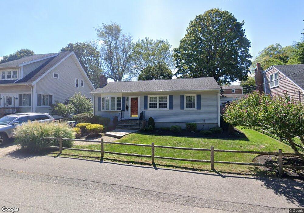
26 Plymouth Rd Braintree, MA 02184
Braintree Highlands NeighborhoodEstimated Value: $638,000 - $741,000
3
Beds
2
Baths
1,440
Sq Ft
$479/Sq Ft
Est. Value
About This Home
This home is located at 26 Plymouth Rd, Braintree, MA 02184 and is currently estimated at $689,609, approximately $478 per square foot. 26 Plymouth Rd is a home located in Norfolk County with nearby schools including Boston Higashi School, Lighthouse Baptist Christian Academy, and Thayer Academy.
Ownership History
Date
Name
Owned For
Owner Type
Purchase Details
Closed on
Sep 17, 2025
Sold by
Foti Vincent J and Foti Anne E
Bought by
Foti Ft and Foti
Current Estimated Value
Purchase Details
Closed on
Dec 13, 1977
Bought by
Foti Vincent J and Foti Anne E
Create a Home Valuation Report for This Property
The Home Valuation Report is an in-depth analysis detailing your home's value as well as a comparison with similar homes in the area
Home Values in the Area
Average Home Value in this Area
Purchase History
| Date | Buyer | Sale Price | Title Company |
|---|---|---|---|
| Foti Ft | -- | -- | |
| Foti Vincent J | -- | -- |
Source: Public Records
Mortgage History
| Date | Status | Borrower | Loan Amount |
|---|---|---|---|
| Previous Owner | Foti Vincent J | $100,000 |
Source: Public Records
Tax History Compared to Growth
Tax History
| Year | Tax Paid | Tax Assessment Tax Assessment Total Assessment is a certain percentage of the fair market value that is determined by local assessors to be the total taxable value of land and additions on the property. | Land | Improvement |
|---|---|---|---|---|
| 2025 | $5,753 | $576,500 | $339,700 | $236,800 |
| 2024 | $5,208 | $549,400 | $308,400 | $241,000 |
| 2023 | $4,919 | $504,000 | $277,100 | $226,900 |
| 2022 | $4,748 | $477,200 | $250,300 | $226,900 |
| 2021 | $4,368 | $439,000 | $226,200 | $212,800 |
| 2020 | $4,125 | $418,400 | $205,600 | $212,800 |
| 2019 | $3,945 | $391,000 | $196,700 | $194,300 |
| 2018 | $3,856 | $365,800 | $178,800 | $187,000 |
| 2017 | $3,833 | $356,900 | $169,900 | $187,000 |
| 2016 | $3,773 | $343,600 | $160,900 | $182,700 |
| 2015 | $3,507 | $316,800 | $134,100 | $182,700 |
| 2014 | $3,319 | $290,600 | $128,700 | $161,900 |
Source: Public Records
Map
Nearby Homes
- 16 Winthrop Ave
- 61 Woodside Ave
- 1579 Washington St
- 44 Arlington Ave
- 104 Milton Rd
- 661 North St
- 107 Meadow Ln Unit A7
- 700 North St
- 184 Richard Rd
- 116 Cardinal Ct
- 469 North St
- 38 Mcdevitt Rd
- 1501 Liberty St
- 115 Richard Rd
- 26 Highland Ave
- 6 E Division St
- 15 Highland Ave
- 614 Pond St Unit 2104
- 614 Pond St Unit 1405
- 614 Pond St Unit 1415
- 24 Plymouth Rd
- 28 Plymouth Rd
- 22 Plymouth Rd
- 39 Wampatuck Rd
- 41 Wampatuck Rd
- 33 Wampatuck Rd
- 29 Wampatuck Rd
- 20 Plymouth Rd
- 17 Wampatuck Rd
- 15 Plymouth Rd
- 45 Wampatuck Rd
- 16 Plymouth Rd
- 11 Wampatuck Rd
- 32 Wampatuck Rd
- 28 Wampatuck Rd
- 36 Wampatuck Rd
- 53 Wampatuck Rd
- 10 Plymouth Rd
- 24 Wampatuck Rd
- 40 Wampatuck Rd