


260 Birmingham St Bridgeport, CT 06606
North End NeighborhoodEstimated payment $1,920/month
Highlights
- Detached Guest House
- Attic
- Level Lot
- Colonial Architecture
- Porch
About This Home
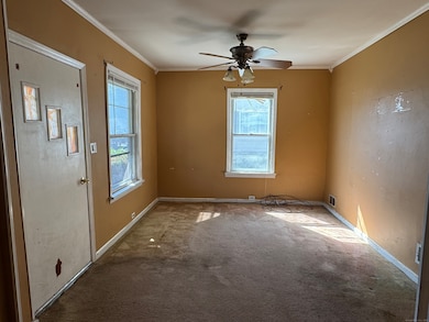
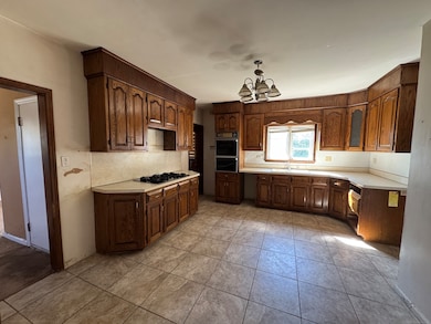
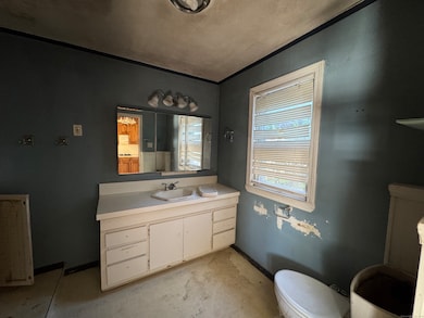
Bidding has closed as of 10/22/2025. They are no accepting any more offers in the auction web site. Investor and contractor special! Welcome to 260 Birmingham Street, located in the heart of Bridgeport's North End. This property offers incredible potential for those looking to renovate and add value. Featuring 3 bedrooms and 1 bathroom across 1,601 sqft of living space, this home sits on a 0.11 acre lot and is just minutes from schools, shops, parks, and public transportation. The property is being sold as-is, where-is. There is an accessory dwelling that also needs extensive rehab. We do not represent that it is even legal. Buyers are responsible for their own due diligence. Seller makes no representations or warranties. Cash or rehab loan only. No inspection or financing contingencies will be entertained. Don't miss this opportunity to bring this property back to life and make it shine again!
Listing Agent
Sanchez Asset Realty Brokerage Phone: (203) 913-5899 License #RES.0047562 Listed on: 10/01/2025
Co-Listing Agent
Sanchez Asset Realty Brokerage Phone: (203) 913-5899 License #REB.0757785
Home Details
Home Type
- Single Family
Est. Annual Taxes
- $7,220
Year Built
- Built in 1921
Lot Details
- 4,792 Sq Ft Lot
- Level Lot
- Property is zoned Miscellaneous Residential
Parking
- 2 Parking Spaces
Home Design
- Colonial Architecture
- Stone Foundation
- Frame Construction
- Asphalt Shingled Roof
- Shingle Siding
Interior Spaces
- Unfinished Basement
- Basement Fills Entire Space Under The House
- Attic or Crawl Hatchway Insulated
Bedrooms and Bathrooms
- 3 Bedrooms
- 1 Full Bathroom
Additional Features
- Porch
- Detached Guest House
- Heating System Uses Natural Gas
Listing and Financial Details
- Assessor Parcel Number 34383
Map
Home Values in the Area
Average Home Value in this Area
Tax History
| Year | Tax Paid | Tax Assessment Tax Assessment Total Assessment is a certain percentage of the fair market value that is determined by local assessors to be the total taxable value of land and additions on the property. | Land | Improvement |
|---|---|---|---|---|
| 2025 | $7,220 | $166,160 | $75,310 | $90,850 |
| 2024 | $7,220 | $166,160 | $75,310 | $90,850 |
| 2023 | $7,220 | $166,160 | $75,310 | $90,850 |
| 2022 | $7,220 | $166,160 | $75,310 | $90,850 |
| 2021 | $7,220 | $166,160 | $75,310 | $90,850 |
| 2020 | $6,963 | $128,960 | $43,270 | $85,690 |
| 2019 | $6,963 | $128,960 | $43,270 | $85,690 |
| 2018 | $7,012 | $128,960 | $43,270 | $85,690 |
| 2017 | $7,012 | $128,960 | $43,270 | $85,690 |
| 2016 | $7,012 | $128,960 | $43,270 | $85,690 |
| 2015 | $7,270 | $172,270 | $49,980 | $122,290 |
| 2014 | $7,270 | $172,270 | $49,980 | $122,290 |
Property History
| Date | Event | Price | List to Sale | Price per Sq Ft |
|---|---|---|---|---|
| 11/03/2025 11/03/25 | Pending | -- | -- | -- |
| 10/01/2025 10/01/25 | For Sale | $249,600 | -- | $106 / Sq Ft |
Purchase History
| Date | Type | Sale Price | Title Company |
|---|---|---|---|
| Warranty Deed | $188,000 | -- |
Mortgage History
| Date | Status | Loan Amount | Loan Type |
|---|---|---|---|
| Open | $255,000 | No Value Available | |
| Closed | $230,350 | No Value Available | |
| Closed | $195,800 | No Value Available | |
| Closed | $5,600 | Purchase Money Mortgage |
Source: SmartMLS
MLS Number: 24130639
APN: BRID-002324-000009
Disclaimer: Certain information contained herein is derived from information provided by parties other than Homes.com. All information provided is deemed reliable, but is not guaranteed to be accurate and should be independently verified.
![]() IDX information is provided exclusively for personal, non-commercial use, and may not be used for any purpose other than to identify prospective properties consumers may be interested in purchasing. Information is deemed reliable but not guaranteed.
IDX information is provided exclusively for personal, non-commercial use, and may not be used for any purpose other than to identify prospective properties consumers may be interested in purchasing. Information is deemed reliable but not guaranteed.
- 214 Burnsford Ave
- 113 Clark St
- 184 Merritt St
- 3401 Main St
- 1095 Wayne St
- 325 Goldenrod Ave
- 354 Beechmont Ave
- 339 Goldenrod Ave
- 520 Wayne St
- 234 Savoy St
- 604 Birmingham St
- 375 Ruth St
- 376 Savoy St
- 45 Stevens St Unit 2
- 25 Broadway
- 5 Stevens St
- 245 Glendale Ave Unit D8
- 520 Savoy St
- 215 Overland Ave
- 38 Enid St Unit B
