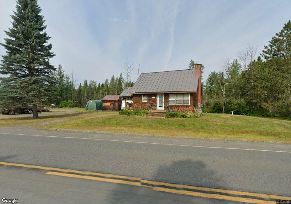
260 Main St Eustis, ME 04936
Estimated Value: $243,902 - $269,000
3
Beds
1
Bath
936
Sq Ft
$273/Sq Ft
Est. Value
About This Home
This home is located at 260 Main St, Eustis, ME 04936 and is currently estimated at $255,226, approximately $272 per square foot. 260 Main St is a home located in Franklin County with nearby schools including Stratton Elementary School.
Ownership History
Date
Name
Owned For
Owner Type
Purchase Details
Closed on
Sep 15, 2022
Sold by
Obie Daniel S and Obie Rhonda M
Bought by
Aube Craig and Aube Carrie
Current Estimated Value
Purchase Details
Closed on
Aug 2, 2011
Sold by
Coles Carol R
Bought by
Obie Daniel S and Obie Rhonda M
Home Financials for this Owner
Home Financials are based on the most recent Mortgage that was taken out on this home.
Original Mortgage
$65,600
Interest Rate
4.52%
Mortgage Type
Purchase Money Mortgage
Purchase Details
Closed on
Mar 10, 2011
Sold by
Coles Malcolm F
Bought by
Coles Carol R
Create a Home Valuation Report for This Property
The Home Valuation Report is an in-depth analysis detailing your home's value as well as a comparison with similar homes in the area
Purchase History
| Date | Buyer | Sale Price | Title Company |
|---|---|---|---|
| Aube Craig | $225,000 | None Available | |
| Obie Daniel S | -- | -- | |
| Coles Carol R | -- | -- |
Source: Public Records
Mortgage History
| Date | Status | Borrower | Loan Amount |
|---|---|---|---|
| Previous Owner | Obie Daniel S | $65,600 |
Source: Public Records
Tax History
| Year | Tax Paid | Tax Assessment Tax Assessment Total Assessment is a certain percentage of the fair market value that is determined by local assessors to be the total taxable value of land and additions on the property. | Land | Improvement |
|---|---|---|---|---|
| 2024 | $1,093 | $124,900 | $28,600 | $96,300 |
| 2023 | $1,124 | $125,600 | $27,400 | $98,200 |
| 2022 | $932 | $98,100 | $27,400 | $70,700 |
| 2021 | $993 | $77,000 | $21,800 | $55,200 |
| 2020 | $974 | $77,900 | $21,800 | $56,100 |
| 2019 | $943 | $77,900 | $21,800 | $56,100 |
| 2018 | $1,031 | $78,700 | $21,800 | $56,900 |
| 2017 | $201 | $78,800 | $21,800 | $57,000 |
| 2016 | $1,016 | $79,600 | $21,800 | $57,800 |
| 2015 | $1,063 | $80,500 | $21,800 | $58,700 |
| 2014 | $897 | $81,500 | $21,800 | $59,700 |
| 2009 | -- | $86,300 | $22,000 | $64,300 |
Source: Public Records
Map
Nearby Homes
- 9 Tranquility Ln
- 186 Main St
- 27 Peabody Rd
- 14 Dam Rd
- 12 Bog Rd
- 11 Porcupine Trail
- 27 Reed Rd
- 81 B Red Pine Ln
- 6-01 Eustis Ridge Rd
- 60&66 Gravel Pit Rd
- 484 Eustis Ridge Rd
- 233 Porter Nadeau Rd
- 95-4 Lot D Porter Nadeau Rd
- 64 Ip Rd
- 54 Eustis Village Rd
- 59 Eustis Village Rd
- 118 Glidden Rd
- 1480 Arnold Trail
- 42 Rabbit Hollow Rd
- 4004 Bigelow Station
- 260 Main Street State Hwy
- 256 Main St
- 6 Grant Cove Community
- 7 Grant Cove Community
- 268 Main St
- 20 Vaughn Rd
- 244 Main St
- 236 Main St
- 15 Grand View Estates
- 229 Main St
- 234 Main St
- 291 Main St
- 14 Vaughn Rd
- 14 lots Off Vaughn Rd
- 221 Main St
- 222 Main St
- Lot16A12 Off Vaughn Rd
- 295 Main St
- 47 Hawks Bluff Rd
- 217 Main St
Your Personal Tour Guide
Ask me questions while you tour the home.