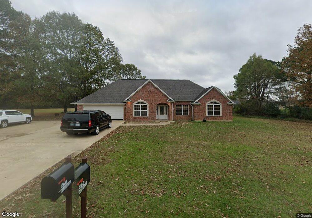
260 N Kaye Dr Broken Bow, OK 74728
Estimated Value: $138,000 - $544,000
3
Beds
2
Baths
1,248
Sq Ft
$208/Sq Ft
Est. Value
About This Home
This home is located at 260 N Kaye Dr, Broken Bow, OK 74728 and is currently estimated at $259,626, approximately $208 per square foot. 260 N Kaye Dr is a home with nearby schools including Dierks Elementary School, Bennett Elementary School, and Rector Johnson Middle School.
Ownership History
Date
Name
Owned For
Owner Type
Purchase Details
Closed on
Jul 13, 2017
Sold by
Going Christopher Tyrone and Going Brandi Lynne
Bought by
Abernathy George Bartley
Current Estimated Value
Purchase Details
Closed on
Feb 1, 2012
Sold by
Holman Cole Stacey Leann and Cole Dan
Bought by
Going Christopher Tyrone and Going Brandilynne
Create a Home Valuation Report for This Property
The Home Valuation Report is an in-depth analysis detailing your home's value as well as a comparison with similar homes in the area
Home Values in the Area
Average Home Value in this Area
Purchase History
| Date | Buyer | Sale Price | Title Company |
|---|---|---|---|
| Abernathy George Bartley | $104,000 | None Available | |
| Going Christopher Tyrone | $24,000 | None Available |
Source: Public Records
Tax History
| Year | Tax Paid | Tax Assessment Tax Assessment Total Assessment is a certain percentage of the fair market value that is determined by local assessors to be the total taxable value of land and additions on the property. | Land | Improvement |
|---|---|---|---|---|
| 2025 | $242 | $2,908 | $59 | $2,849 |
| 2023 | $230 | $2,769 | $56 | $2,713 |
| 2022 | $227 | $2,769 | $56 | $2,713 |
| 2021 | $223 | $2,769 | $56 | $2,713 |
| 2020 | $231 | $2,839 | $56 | $2,783 |
| 2019 | $229 | $2,800 | $56 | $2,744 |
| 2018 | $237 | $2,867 | $56 | $2,811 |
| 2017 | $239 | $2,868 | $56 | $2,812 |
| 2016 | $242 | $2,881 | $56 | $2,825 |
| 2015 | $247 | $2,881 | $56 | $2,825 |
| 2014 | $249 | $2,881 | $56 | $2,825 |
Source: Public Records
Map
Nearby Homes
- 208 N Kaye Dr
- 10 Hickory Ridge Rd
- 252 Cedar Hills Trail
- 81 Hickory Ridge Rd
- 159 Sycamore View Ln
- 0 Dr Unit 1152244
- 0 Fannie Mae Lot 1 Dr
- 0 Fannie Mae Dr
- 204 W Sherry Ln
- 40 Preserve Way
- 47 Honor Ct
- 86 Preserve Way
- 161 Champion Way
- 1664 N US Highway 259
- 571 Raintree Rd
- 136 Preserve Way
- 238 Eagle Mountain Trail
- 47 Canoe Birch Trail
- 280 Palo Verde Trail
- 102 Eagle Mountain Trail
- 300 Kay Dr
- 205 N Kaye Dr
- 205 N Kaye Dr
- 300 N Moyer Dr
- 111 Moyer Dr Unit ADD
- 301 Moyer Dr
- 301 Kay Dr
- 211 Kay Dr
- 109 Moyer Dr
- 45 Hickory Ridge Rd
- 184 Cedar Hills Trail
- 138 Cedar Hills Trail Unit 28
- 145 Secluded Cir
- 152 Hickory Ridge Rd
- 204 Secluded Cir
- 207 Hickory Ridge Rd
- 138 Cedar Hills Trail
- 79 Secluded Cir
- 93 Secluded Cir
- 119 Secluded Cir
Your Personal Tour Guide
Ask me questions while you tour the home.