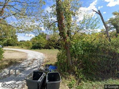
260 Ward Koebel Rd Oregonia, OH 45054
Washington Township NeighborhoodEstimated Value: $230,000 - $363,000
3
Beds
2
Baths
1,436
Sq Ft
$210/Sq Ft
Est. Value
About This Home
This home is located at 260 Ward Koebel Rd, Oregonia, OH 45054 and is currently estimated at $301,172, approximately $209 per square foot. 260 Ward Koebel Rd is a home located in Warren County with nearby schools including Clinton-Massie Elementary School, Clinton-Massie Middle School, and Clinton-Massie High School.
Ownership History
Date
Name
Owned For
Owner Type
Purchase Details
Closed on
Aug 20, 2013
Sold by
Smith Jason P
Bought by
Smith Melissa M
Current Estimated Value
Purchase Details
Closed on
Oct 13, 2008
Sold by
Wells Fargo Bank Na
Bought by
Smith Jason P and Smith Melissa M
Home Financials for this Owner
Home Financials are based on the most recent Mortgage that was taken out on this home.
Original Mortgage
$83,794
Interest Rate
6.09%
Mortgage Type
FHA
Purchase Details
Closed on
Mar 14, 2008
Sold by
Gilbert Mark and Case #Alias 07Cv68565
Bought by
Wells Fargo Bank Na
Purchase Details
Closed on
May 20, 1993
Sold by
Howard Maue and Howard J.
Bought by
Smith Smith and Smith Walter
Create a Home Valuation Report for This Property
The Home Valuation Report is an in-depth analysis detailing your home's value as well as a comparison with similar homes in the area
Home Values in the Area
Average Home Value in this Area
Purchase History
| Date | Buyer | Sale Price | Title Company |
|---|---|---|---|
| Smith Melissa M | -- | None Available | |
| Smith Jason P | $84,900 | Aspen Titel Agency Inc | |
| Wells Fargo Bank Na | $143,416 | None Available | |
| Smith Smith | $40,000 | -- |
Source: Public Records
Mortgage History
| Date | Status | Borrower | Loan Amount |
|---|---|---|---|
| Open | Smith Jason P | $63,000 | |
| Closed | Smith Melissa M | $35,000 | |
| Closed | Smith Jason P | $83,794 |
Source: Public Records
Tax History Compared to Growth
Tax History
| Year | Tax Paid | Tax Assessment Tax Assessment Total Assessment is a certain percentage of the fair market value that is determined by local assessors to be the total taxable value of land and additions on the property. | Land | Improvement |
|---|---|---|---|---|
| 2024 | $2,536 | $77,380 | $46,000 | $31,380 |
| 2023 | $2,014 | $59,230 | $31,430 | $27,800 |
| 2022 | $2,024 | $59,231 | $31,430 | $27,801 |
| 2021 | $1,846 | $59,231 | $31,430 | $27,801 |
| 2020 | $1,716 | $48,157 | $25,554 | $22,603 |
| 2019 | $1,598 | $48,157 | $25,554 | $22,603 |
| 2018 | $1,618 | $48,157 | $25,554 | $22,603 |
| 2017 | $1,458 | $42,602 | $22,754 | $19,849 |
| 2016 | $1,506 | $42,602 | $22,754 | $19,849 |
| 2015 | $1,506 | $42,602 | $22,754 | $19,849 |
| 2014 | $1,498 | $41,300 | $22,750 | $18,550 |
| 2013 | $1,579 | $44,940 | $22,750 | $22,190 |
Source: Public Records
Map
Nearby Homes
- Lot C Blazing Trail
- Lot B Blazing Trail
- 732 Settlemyre Rd
- 0 St Rt 350 Unit 923676
- 6660 Olive Branch Rd
- 0 Gard Rd Unit 1811548
- 2518 Karson Ct
- 9171 U S 22
- 34 Cobble Stone Ln
- 1 Ohio 350
- 232 N 1st St
- 1190 S Nixon Camp Rd
- 3051 Senior Rd
- 9356 Ohio 350
- 6490 Ohio 350
- 3693 Pansy Rd
- 2084 Corwin Rd
- 676 Hadley Rd
- 7084 U S 22
- Lots 7&8 Middleboro Rd
