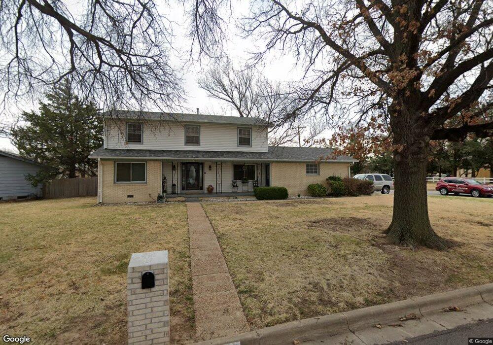
2600 N Pershing St Wichita, KS 67220
Northeast Heights NeighborhoodEstimated Value: $238,000 - $240,495
4
Beds
3
Baths
1,768
Sq Ft
$135/Sq Ft
Est. Value
About This Home
This home is located at 2600 N Pershing St, Wichita, KS 67220 and is currently estimated at $239,248, approximately $135 per square foot. 2600 N Pershing St is a home located in Sedgwick County with nearby schools including Buckner Performing Arts Magnet Elementary School, Stucky Middle School, and Wichita Heights High School.
Ownership History
Date
Name
Owned For
Owner Type
Purchase Details
Closed on
Aug 30, 2000
Sold by
Grays Orstell and Grays Margaret A
Bought by
Cyphers Michael R and Cyphers Joy C
Current Estimated Value
Home Financials for this Owner
Home Financials are based on the most recent Mortgage that was taken out on this home.
Original Mortgage
$84,918
Outstanding Balance
$31,191
Interest Rate
8.21%
Mortgage Type
FHA
Estimated Equity
$208,057
Create a Home Valuation Report for This Property
The Home Valuation Report is an in-depth analysis detailing your home's value as well as a comparison with similar homes in the area
Home Values in the Area
Average Home Value in this Area
Purchase History
| Date | Buyer | Sale Price | Title Company |
|---|---|---|---|
| Cyphers Michael R | -- | Columbian Natl Title Ins Co |
Source: Public Records
Mortgage History
| Date | Status | Borrower | Loan Amount |
|---|---|---|---|
| Open | Cyphers Michael R | $84,918 |
Source: Public Records
Tax History Compared to Growth
Tax History
| Year | Tax Paid | Tax Assessment Tax Assessment Total Assessment is a certain percentage of the fair market value that is determined by local assessors to be the total taxable value of land and additions on the property. | Land | Improvement |
|---|---|---|---|---|
| 2025 | $1,978 | $22,127 | $5,486 | $16,641 |
| 2023 | $1,978 | $18,757 | $2,519 | $16,238 |
| 2022 | $1,811 | $16,457 | $2,369 | $14,088 |
| 2021 | $1,765 | $15,525 | $2,369 | $13,156 |
| 2020 | $1,638 | $14,375 | $2,369 | $12,006 |
| 2019 | $1,560 | $13,685 | $2,369 | $11,316 |
| 2018 | $1,487 | $13,030 | $1,725 | $11,305 |
| 2017 | $1,379 | $0 | $0 | $0 |
| 2016 | $1,377 | $0 | $0 | $0 |
| 2015 | $1,358 | $0 | $0 | $0 |
| 2014 | $1,372 | $0 | $0 | $0 |
Source: Public Records
Map
Nearby Homes
- 2631 N Pershing St
- 2726 N Fountain Ave
- 4703 Looman St
- 4813 E 24th St N
- 5018 E 27th St N
- 2717 N Beacon Hill Ct
- 2630 N Parkwood Ln
- 5402 Arlene St
- 5405 Arlene St
- 4425 Salem St
- 2501 N Beacon Hill St
- 5027 Fairmount St
- 5029 Fairmount St
- 5021 Fairmount St
- 5023 Fairmount St
- 4915 N Vassar Ave
- 4911 N Vassar Ave
- 4909 N Vassar Ave
- 4917 N Vassar Ave
- 2643 N Holyoke St
- 2606 N Pershing St
- 4510 E 25th St N
- 2601 N Pershing St
- 2614 N Pershing St
- 2605 N Pershing St
- 2609 N Pershing St
- 2550 N Pershing St
- 2615 N Pershing St
- 4520 E 25th St N
- 4410 E 25th St N
- 2619 N Pershing St
- 2623 N Pershing St
- 2628 N Pershing St
- 2551 N Pershing St
- 2655 N Pershing Ct
- 4600 E 25th St N
- 2627 N Pershing St
- 2659 N Pershing Ct
- 2651 N Pershing Ct
- 2636 N Pershing St