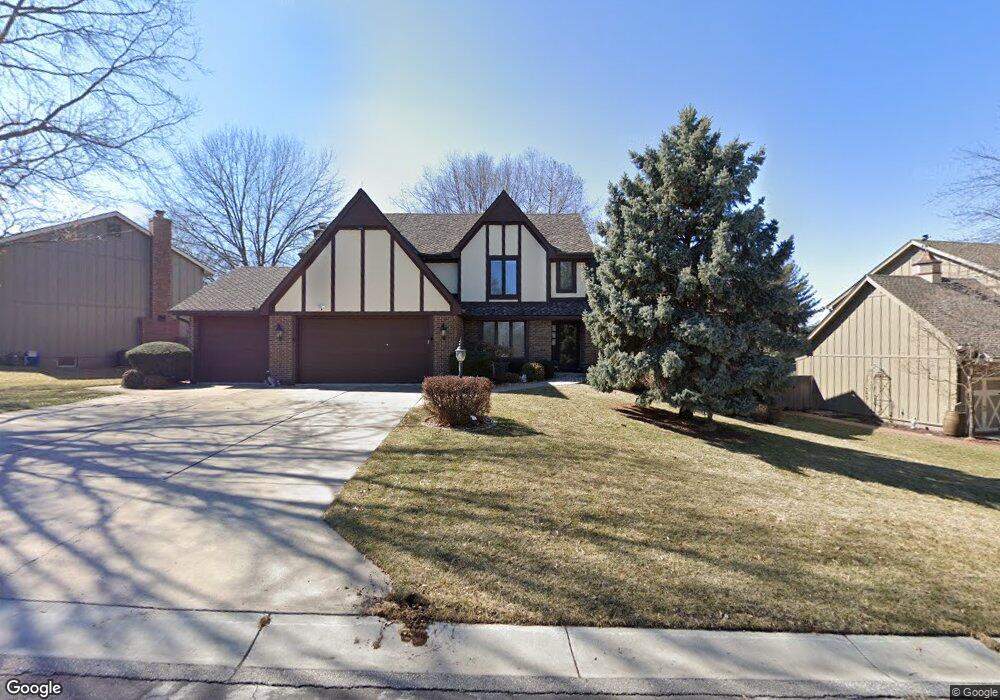
2600 NW Bent Tree Cir Lees Summit, MO 64081
Estimated Value: $531,363 - $592,000
4
Beds
4
Baths
3,533
Sq Ft
$160/Sq Ft
Est. Value
About This Home
This home is located at 2600 NW Bent Tree Cir, Lees Summit, MO 64081 and is currently estimated at $565,091, approximately $159 per square foot. 2600 NW Bent Tree Cir is a home located in Jackson County with nearby schools including Cedar Creek Elementary School, Bernard C. Campbell Middle School, and Lee's Summit North High School.
Ownership History
Date
Name
Owned For
Owner Type
Purchase Details
Closed on
Sep 4, 2018
Sold by
Bank Of Blue Valley
Bought by
Bank Of Blue Valley and The Earl B Reed Trust
Current Estimated Value
Purchase Details
Closed on
Jul 7, 2006
Sold by
Blue Ridge Bank & Trust Co
Bought by
Reed Earl B and Earl B Reed Trust
Purchase Details
Closed on
Jul 22, 1998
Sold by
Commerca Bank Na
Bought by
Blue Ridge Bank & Trust Co and Earl B Reed Trust
Purchase Details
Closed on
Mar 28, 1996
Sold by
Blue Ridge Bank & Trust Co
Bought by
Blue Ridge Bank & Trust Co and Earl B Reed Trust
Create a Home Valuation Report for This Property
The Home Valuation Report is an in-depth analysis detailing your home's value as well as a comparison with similar homes in the area
Home Values in the Area
Average Home Value in this Area
Purchase History
| Date | Buyer | Sale Price | Title Company |
|---|---|---|---|
| Bank Of Blue Valley | -- | None Available | |
| Reed Earl B | -- | None Available | |
| Blue Ridge Bank & Trust Co | -- | -- | |
| Blue Ridge Bank & Trust Co | -- | -- |
Source: Public Records
Tax History Compared to Growth
Tax History
| Year | Tax Paid | Tax Assessment Tax Assessment Total Assessment is a certain percentage of the fair market value that is determined by local assessors to be the total taxable value of land and additions on the property. | Land | Improvement |
|---|---|---|---|---|
| 2025 | $6,098 | $95,735 | $13,013 | $82,722 |
| 2024 | $6,054 | $84,453 | $6,057 | $78,396 |
| 2023 | $6,054 | $84,453 | $6,057 | $78,396 |
| 2022 | $5,844 | $72,390 | $8,074 | $64,316 |
| 2021 | $5,965 | $72,390 | $8,074 | $64,316 |
| 2020 | $5,735 | $68,927 | $8,074 | $60,853 |
| 2019 | $5,579 | $68,927 | $8,074 | $60,853 |
| 2018 | $5,232 | $59,988 | $7,027 | $52,961 |
| 2017 | $5,232 | $59,988 | $7,027 | $52,961 |
| 2016 | $5,160 | $58,558 | $5,643 | $52,915 |
| 2014 | $5,367 | $59,708 | $5,097 | $54,611 |
Source: Public Records
Map
Nearby Homes
- 2536 NW Bent Tree Cir
- 2616 NW Lookout Ridge
- 2501 NW Shady Bend Ln
- 2508 NW Bent Tree Cir
- 2503 NW Windwood Dr
- 932 NW Bent Tree Dr
- 813 NW High Point Dr
- 2257 NW Summerfield Dr
- 130 NW Ambersham Dr
- 505 NW Ambersham Dr
- 928 NW Cedar Creek Ln
- 1031 NW Cedar Creek Ln
- 13004 E 99th St
- 2007 NW Chipman Rd
- 2122 NW Ashurst Dr
- 361 NW Patch Ct
- 2090 NW O'Brien Rd
- 2214 NW Killarney Ln
- 2082 NW O'Brien Rd
- 200 NW Cody Dr
- 2548 NW Bent Tree Cir
- 2604 NW Bent Tree Cir
- 2605 NW Bent Tree Cir
- 2561 NW Bent Tree Cir
- 2609 NW Bent Tree Cir
- 2557 NW Bent Tree Cir
- 2610 NW Bent Tree Cir
- 2544 NW Bent Tree Cir
- 2613 NW Bent Tree Cir
- 2600 NW Lookout Ridge
- 2601 NW Lookout Ridge
- 2617 NW Bent Tree Cir
- 2529 NW Overbrook Dr
- 2620 NW Bent Tree Cir
- 2540 NW Bent Tree Cir
- 2530 NW Overbrook Dr
- 2549 NW Bent Tree Cir
- 2605 NW Lookout Ridge
- 2604 NW Lookout Ridge
- 2545 NW Bent Tree Cir