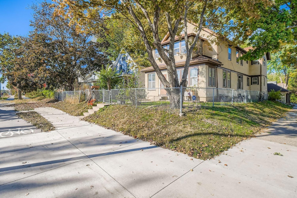

2600 Plymouth Ave N Unit A Minneapolis, MN 55411
Willard-Hay NeighborhoodEstimated payment $1,266/month
Highlights
- Sun or Florida Room
- Stainless Steel Appliances
- 1-Story Property
- Corner Lot
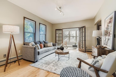
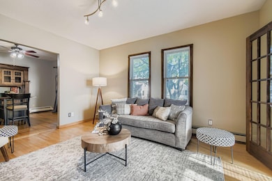
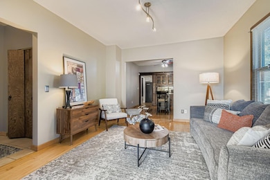
- Living Room
- 2-minute walk to Farwell Park
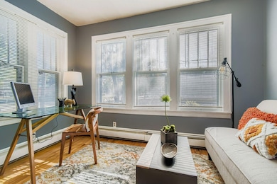
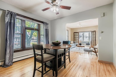
About This Home
If you’ve ever wanted to live near Theo Wirth Park, this is your opportunity! This beautifully maintained
condo perfectly blends charm and modern comfort. The current owner was intentional about preserving the home’s original character while thoughtfully refreshing the space. Inside, you’ll find gorgeous hardwood floors throughout, sun-drenched original windows, updated appliances, and a one-car garage.
Don’t miss your chance to call this beautiful space home — schedule your showing today!
Property Details
Home Type
- Multi-Family
Est. Annual Taxes
- $1,599
Year Built
- Built in 1912
Lot Details
- Lot Dimensions are 40x118
- Corner Lot
HOA Fees
- $263 Monthly HOA Fees
Parking
- 1 Car Garage
- On-Street Parking
Home Design
- Property Attached
Interior Spaces
- 1,339 Sq Ft Home
- 1-Story Property
- Living Room
- Dining Room
- Sun or Florida Room
Kitchen
- Cooktop
- Microwave
- Dishwasher
- Stainless Steel Appliances
Bedrooms and Bathrooms
- 2 Bedrooms
- 1 Full Bathroom
Laundry
- Dryer
- Washer
Unfinished Basement
- Shared Basement
- Block Basement Construction
- Basement Storage
Utilities
- Window Unit Cooling System
- Baseboard Heating
Community Details
- Association fees include trash, sewer
- Plymouth Place Condo Association, Phone Number (612) 821-7443
- Condo 0331 2600 Plymouth Place Subdivision
Listing and Financial Details
- Assessor Parcel Number 1702924430215
Map
Home Values in the Area
Average Home Value in this Area
Tax History
| Year | Tax Paid | Tax Assessment Tax Assessment Total Assessment is a certain percentage of the fair market value that is determined by local assessors to be the total taxable value of land and additions on the property. | Land | Improvement |
|---|---|---|---|---|
| 2024 | $1,599 | $108,000 | $9,000 | $99,000 |
| 2023 | $1,495 | $115,000 | $9,000 | $106,000 |
| 2022 | $1,794 | $112,000 | $7,000 | $105,000 |
| 2021 | $1,678 | $130,000 | $4,800 | $125,200 |
| 2020 | $1,667 | $126,000 | $4,800 | $121,200 |
| 2019 | $1,896 | $115,500 | $4,800 | $110,700 |
| 2018 | $1,609 | $109,000 | $4,800 | $104,200 |
| 2017 | $1,502 | $92,500 | $4,400 | $88,100 |
| 2016 | $1,857 | $112,000 | $4,400 | $107,600 |
| 2015 | $1,852 | $106,500 | $4,400 | $102,100 |
| 2014 | -- | $106,500 | $4,400 | $102,100 |
Property History
| Date | Event | Price | List to Sale | Price per Sq Ft |
|---|---|---|---|---|
| 10/26/2025 10/26/25 | For Sale | $165,000 | -- | $123 / Sq Ft |
Purchase History
| Date | Type | Sale Price | Title Company |
|---|---|---|---|
| Warranty Deed | $105,500 | Edina Realty Title Inc | |
| Warranty Deed | $137,500 | -- | |
| Deed | $105,500 | -- |
Mortgage History
| Date | Status | Loan Amount | Loan Type |
|---|---|---|---|
| Open | $84,400 | New Conventional | |
| Closed | $105,500 | No Value Available |
Source: NorthstarMLS
MLS Number: 6809294
APN: 17-029-24-43-0215
Disclaimer: Certain information contained herein is derived from information provided by parties other than Homes.com. All information provided is deemed reliable, but is not guaranteed to be accurate and should be independently verified.
![]() Based on information submitted to the MLS GRID. All data is obtained from various sources and may not have been verified by broker or MLS GRID. Supplied Open House Information is subject to change without notice. All information should be independently reviewed and verified for accuracy. Properties may or may not be listed by the office/agent presenting the information. Some IDX listings have been excluded from this website.
Based on information submitted to the MLS GRID. All data is obtained from various sources and may not have been verified by broker or MLS GRID. Supplied Open House Information is subject to change without notice. All information should be independently reviewed and verified for accuracy. Properties may or may not be listed by the office/agent presenting the information. Some IDX listings have been excluded from this website.
The Digital Millennium Copyright Act of 1998, 17 U.S.C. § 512 (the “DMCA”) provides recourse for copyright owners who believe that material appearing on the Internet infringes their rights under U.S. copyright law. If you believe in good faith that any content or material made available in connection with our website or services infringes your copyright, you (or your agent) may send us a notice requesting that the content or material be removed, or access to it blocked.
Notices must be sent in writing by email to DMCAnotice@MLSGrid.com.
The DMCA requires that your notice of alleged copyright infringement include the following information:
(1) description of the copyrighted work that is the subject of claimed infringement;
(2) description of the alleged infringing content and information sufficient to permit us to locate the content;
(3) contact information for you, including your address, telephone number and email address;
(4) a statement by you that you have a good faith belief that the content in the manner complained of is not authorized by the copyright owner, or its agent, or by the operation of any law;
(5) a statement by you, signed under penalty of perjury, that the information in the notification is accurate and that you have the authority to enforce the copyrights that are claimed to be infringed; and
(6) a physical or electronic signature of the copyright owner or a person authorized to act on the copyright owner’s behalf. Failure to include all of the above information may result in the delay of the processing of your complaint.
- 1332 Upton Ave N
- 1336 Russell Ave N
- 1400 Queen Ave N
- 1423 Penn Ave N
- 1214 Penn Ave N
- 1642 Thomas Ave N
- 1639 Russell Ave N
- 819 Sheridan Ave N
- 1530 Penn Ave N
- 905 Queen Ave N
- 918 Queen Ave N
- 1519 Oliver Ave N
- 1508 Oliver Ave N
- 811 Queen Ave N
- 1211 Morgan Ave N
- 1429 Morgan Ave N
- 1722 Queen Ave N
- 2604 Golden Valley Rd
- 1800 Penn Ave N
- 615 Russell Ave N
- 903 Sheridan Ave N Unit Upper Unit
- 910 Oliver Ave N Unit 1
- 910 Oliver Ave N Unit 3
- 621 Morgan Ave N Unit 1
- 1115 Humboldt Ave N
- 2000 W Broadway Ave NE
- 2505 Penn Ave N
- 1315 Olson Memorial Hwy
- 1800 Fremont Ave N
- 560 Humboldt Ave N
- 2622 Upton Ave N
- 2025 Emerson Ave N
- 265 Girard Ave N
- 2708 Penn Ave N Unit 2
- 1207 Glenwood Ave
- 835 W Broadway Ave
- 1422 26th Ave N Unit 1
- 2700 Irving Ave N Unit 2702
- 400 Natchez Ave N
- 209 Westwood Dr N
