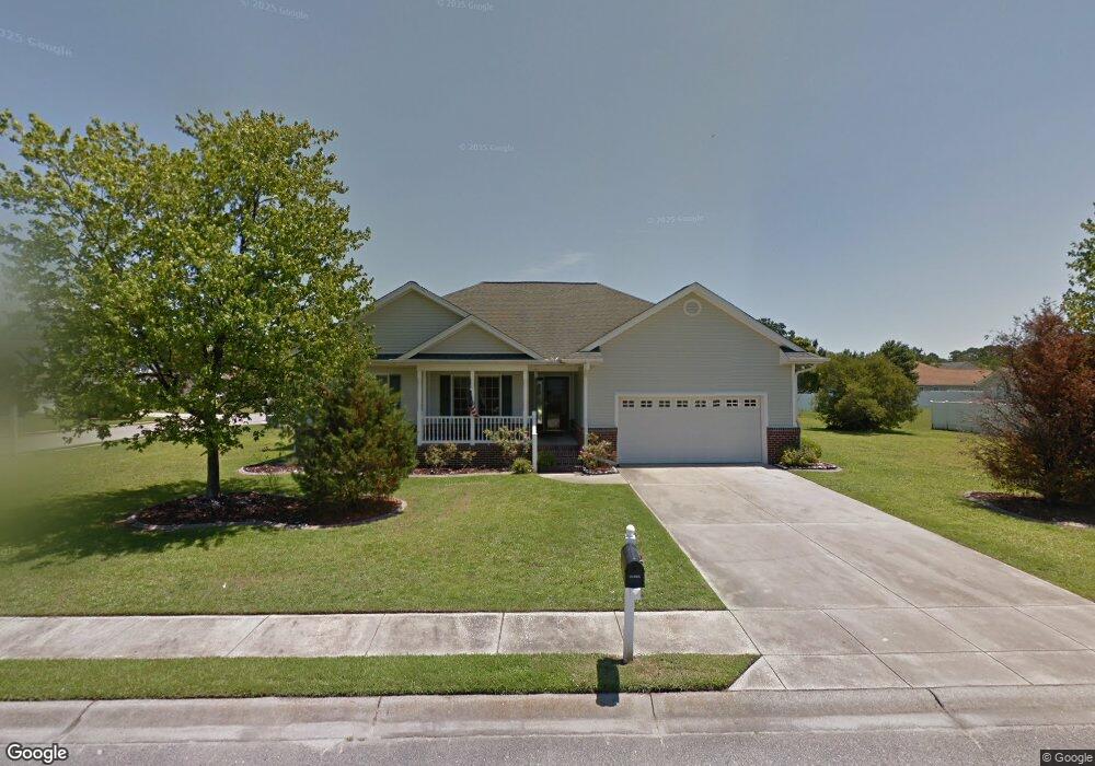
2601 Corn Pile Rd Myrtle Beach, SC 29588
Estimated Value: $308,000 - $318,000
3
Beds
2
Baths
1,474
Sq Ft
$212/Sq Ft
Est. Value
About This Home
This home is located at 2601 Corn Pile Rd, Myrtle Beach, SC 29588 and is currently estimated at $312,338, approximately $211 per square foot. 2601 Corn Pile Rd is a home located in Horry County with nearby schools including Forestbrook Elementary School, Forestbrook Middle School, and Socastee High School.
Ownership History
Date
Name
Owned For
Owner Type
Purchase Details
Closed on
Nov 15, 2021
Sold by
Mcnett Maurice L
Bought by
Imiola Sue Ann and Imiola Jeffrey Joseph
Current Estimated Value
Purchase Details
Closed on
Nov 30, 2006
Sold by
Mountain Top Llc
Bought by
Mcnett Maurice L and Mcnett Kathleen L
Home Financials for this Owner
Home Financials are based on the most recent Mortgage that was taken out on this home.
Original Mortgage
$169,900
Interest Rate
6.29%
Mortgage Type
Purchase Money Mortgage
Purchase Details
Closed on
Jan 2, 2006
Sold by
Smith James L and Smith Lisa H
Bought by
Mountain Top Llc
Purchase Details
Closed on
Dec 20, 2004
Sold by
Malinski Marissa B and Malinski Jerome
Bought by
Smith James L and Smith Lisa Hawkins
Purchase Details
Closed on
Nov 4, 2002
Sold by
Malinski Marissa
Bought by
Malinski Marissa and Malinski Jerome
Purchase Details
Closed on
Jun 15, 2001
Sold by
Malinski Jerome
Bought by
Malinski Marissa
Purchase Details
Closed on
Mar 5, 2001
Sold by
Hunters Ridge Of Myrtle Beach Inc
Bought by
Malinski Jerome and Malinski Marissa
Create a Home Valuation Report for This Property
The Home Valuation Report is an in-depth analysis detailing your home's value as well as a comparison with similar homes in the area
Home Values in the Area
Average Home Value in this Area
Purchase History
| Date | Buyer | Sale Price | Title Company |
|---|---|---|---|
| Imiola Sue Ann | $264,000 | -- | |
| Mcnett Maurice L | $199,000 | None Available | |
| Mountain Top Llc | -- | None Available | |
| Smith James L | $133,000 | -- | |
| Malinski Marissa | -- | -- | |
| Malinski Marissa | -- | -- | |
| Malinski Jerome | $26,900 | -- |
Source: Public Records
Mortgage History
| Date | Status | Borrower | Loan Amount |
|---|---|---|---|
| Previous Owner | Mcnett Maurice L | $169,900 |
Source: Public Records
Tax History Compared to Growth
Tax History
| Year | Tax Paid | Tax Assessment Tax Assessment Total Assessment is a certain percentage of the fair market value that is determined by local assessors to be the total taxable value of land and additions on the property. | Land | Improvement |
|---|---|---|---|---|
| 2024 | $1,135 | $11,380 | $4,000 | $7,380 |
| 2023 | $1,135 | $10,245 | $1,863 | $8,382 |
| 2021 | $3,459 | $10,245 | $1,863 | $8,382 |
| 2020 | $2,147 | $10,245 | $1,863 | $8,382 |
| 2019 | $2,147 | $10,245 | $1,863 | $8,382 |
| 2018 | $1,997 | $9,183 | $1,407 | $7,776 |
| 2017 | $1,982 | $9,183 | $1,407 | $7,776 |
| 2016 | -- | $6,122 | $938 | $5,184 |
| 2015 | $578 | $6,122 | $938 | $5,184 |
| 2014 | $534 | $6,122 | $938 | $5,184 |
Source: Public Records
Map
Nearby Homes
- 2723 Canvasback Trail
- 2714 Canvasback Trail
- 2707 Canvasback Trail
- 2595 Buck Scrape Rd
- 2703 Canvasback Trail
- 2668 Corn Pile Rd
- 2513 Hunters Trail
- 2529 Hunters Trail
- 2459 Hunters Trail
- 2571 Wild Game Trail
- 264 La Patos Dr
- 2650 Wild Game Trail
- 2425 Hunters Trail
- 400 Dog Pen Ct
- 771 Harrison Mill St
- 3845 Camden Dr
- 781 Harrison Mill St
- 4121 Whatuthink Rd
- Lot 725 Zoe Way Unit Lot 725 Lexington
- 276 Forestbrook Cove Cir
- 2601 Corn Pile Rd
- 2731 Canvasback Trail
- 2605 Corn Pile Rd
- 2729 Canvasback Trail
- 2607 Corn Pile Rd
- 2600 Corn Pile Rd
- 2602 Corn Pile Rd
- 2734 Canvasback Trail
- 2732 Canvasback Trail
- 2730 Canvasback Trail
- 2736 Canvasback Trail
- 2609 Corn Pile Rd
- 2727 Canvasback Trail
- 2604 Corn Pile Rd
- 2728 Canvasback Trail
- 2738 Canvasback Trail
- 2611 Corn Pile Rd
- 2725 Canvasback Trail
- 2726 Canvasback Trail Unit Hunters Ridge
- 2726 Canvasback Trail